Rabbits, deer, badgers and foxes live wild there and lots and lots of gray squirrels. In April/May the wooded area is a mass of bluebells. The top of the hill has open fields with stunning views to the south. At GZ there is an almost 180 degree views to the south, you can see Shalford, Blackheath, Chinthurst Hill and even the South Downs on a clear day! There is also a massive family of rabbits that live 10m from ground zero.
Bring water and a container to mix water and soil in to find the pH (you can find UI paper in my nearby cache The Chantries: The 7 Wonders of Guildford


You can park in the Chantries car park off Pilgrims way for free.

Now on to the EarthCache!
The rock types in the Guildford area are all sedimentary and were originally set down as water-borne deposits in horizontal layers (strata), so the rocks at the top are the youngest and the rocks become older down through the strata sequence.
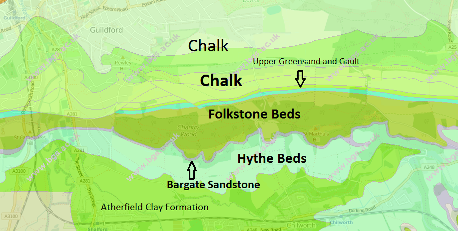
The Chantries sit on the Folkestone Beds which is part of the Lower Greensand group. The Folkestone Beds consist of loosely consolidated sand grains, deposited In an inshore area of sea with strong currents and with sand dunes just onshore. The sand grains are cemented together by iron compounds, which are oxidised when exposed to air, causing the sand grains to become loose and stained yellow or orange (this is especially obvious on the nearby St Martha's hill). Within the sandstone are veins of hard ironstone called carstone. All of the sandstones are permeable and are aquifers (i.e. it stores water in a natural underground reservoir the top of it is called the water table). The Folkestone Beds often form an escarpment (steep slope) in the area. The Bargate Beds (they are start just off the escarpment to the south of GZ) are about 20 meters thick and have little effect on relief, but the hard sandstone is sometimes quarried to use as a building stone: its sand grains are held together by a calcium carbonate cement, so it is not stained red and looks like a course grained Chalk. The Hythe Beds start 20 or so meters from the top of the escarpment. They consist of a greyish-green sandstone and some dinosaur fossils have been found in it.
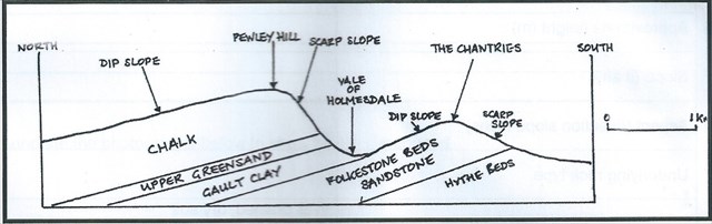
All of the rock in the Guildford area were uplifted and folded during the mountain building period of the Alpine Orogeny that occurred about 25 million years ago. This area was at the northern edge of the folding and the Alps were formed by the same event. The rocks were folded into a compound anticline called an anticlinorium and this Wealden Anticline has subsequently been denuded, exposing the older rocks between the overlying Chalk. The axes of the folds run east-west
Questions
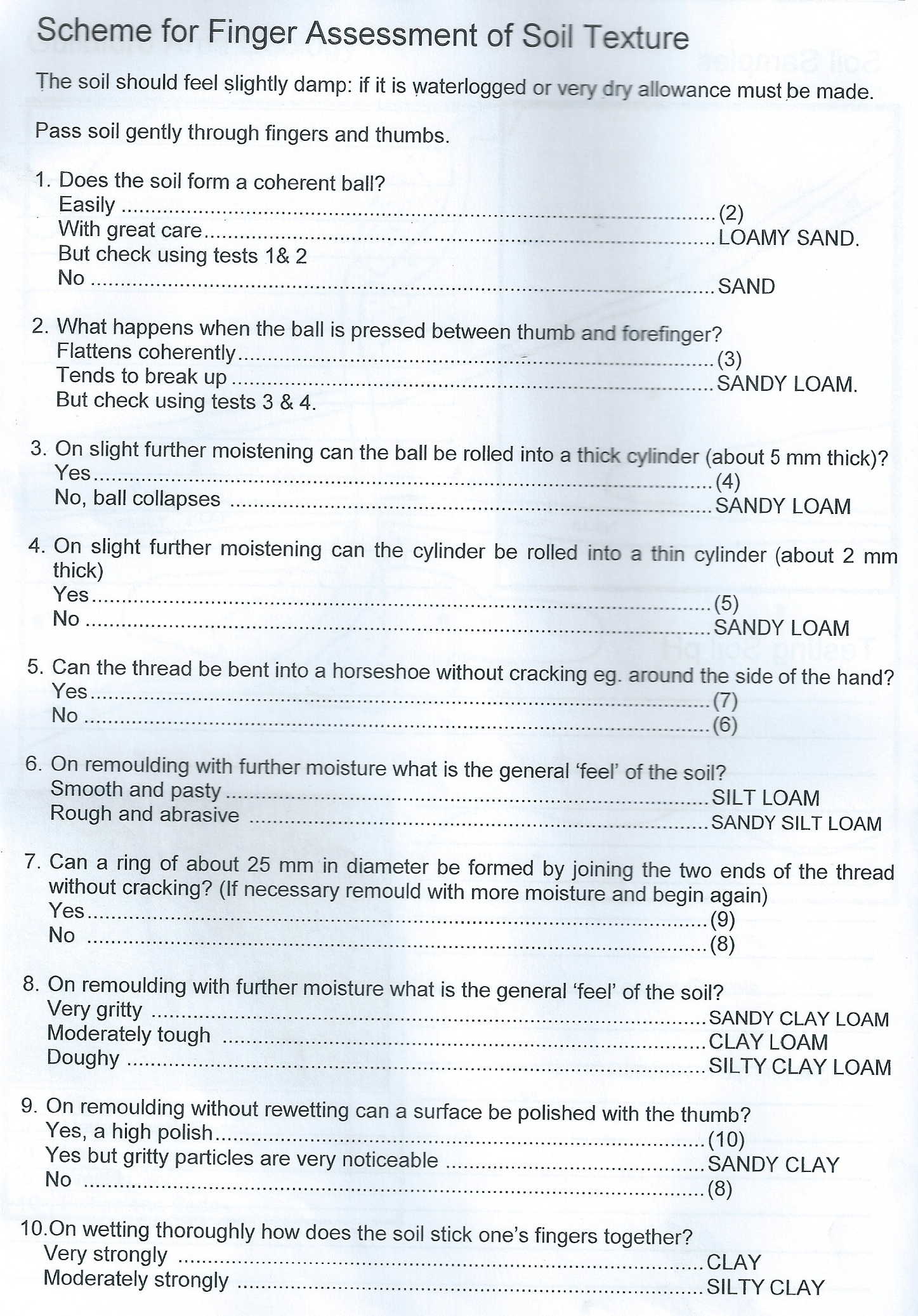
- Which soil type is it (use finger assessment of soil texture scheme below)?
- Smear the soil onto a sheet of paper and comment on its colour, and why it is this colour
- What is the pH of the soil (you can find universal indicator paper in my nearby cache The Chantries: The 7 Wonders of Guildford. There are other methods to find the pH of soil without using UI paper.
- Why is the pH what it is?
- what type of vegetation is there about 100 meters north of GZ and why is this? (GZ used to be like this but has been cleared)
- Optional take a picture of yourself at The Chantries.
- We really enjoy the anecdotes and experiences from visiting the earthcache and gathering the data so we'd rather not see simply 'TFTC' or :-).
Please email me the answers and don't leave any clues in the logs!
I will delete any peoples finds who don't email me the answers
This is my first EarthCache so please leave feedback.
If you have any questions please feel free to email me!