This is a multi cache that will take you to several historic locations in Stamping Ground where you will learn some interesting information about the town. There are a total of 6 stages (5 stages where you will gather information for locating the geocache and the final stage where the geocache is located). Don't forget to gather the required information at each stage in order to locate the final at N38 16.ABC W084 41.DEF
The town of Stamping Ground received its name because this bowl-shaped basin was in one of Kentucky's three major "stamping grounds" formed when bison herds trampled the soil near the springs here. The town grew up around this spring named by the Indians “Buffalo Stamping Ground”. The early explores called it “Buffalo Stamping Ground” and was probably first seen by William McConnell and Charles LeCompte in 1775. Stamping Ground is located on the Alanant-o-wamiowee Trail or “Buffalo Path”. This trail had been established ages ago and was an ancient migratory route since prehistoric times. Stamping Ground was founded in 1790. The town of Stamping Ground was laid out in 1817 on land which had been purchased by Joseph and Scott Herndon. Scott Herndon died before he and his brother could develop their plans for the town which they planned to call “Herndonville”. The town was incorporated on January 24, 1834. Stamping Ground has had three great disasters which almost wiped out the business district. Two fires one on December 2, 1916, which burned both sides of the street and the other in the early 1920s. The third was the devastating tornado outbreak in 1974 when a series of tornadoes hit Kentucky. Stamping Ground was the hardest hit, being almost completely destroyed with only three buildings that remained standing after the tornado. Today the town has approximately 634 inhabitants, one grocery store, one gas station, one garage, one school, one physician, six churches, one bank, one post office, two restaurants, one Masonic Lodge, one pharmacy and a general merchandise store. The city has a Police Department, a Volunteer Fire Department and a County EMS station within the city limits.
Proceed to Stage #1 located at N38 16.300 W084. 41.235 Dr. William Mason was born in 1878 and was a doctor in Stamping Ground. His practice building is located directly behind City Hall from 1913-1920. He was renowned for saving many lives during the Great Influenza Pandemic of 1918-1919 that killed an estimated 50 million people. One fifth of the world's population was attacked by this deadly virus. Within months, it had killed more people than any other illness in recorded history. Dr. Mason died in 1930 and is buried at the Masonic Cemetery at the edge of town.
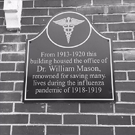
Office of Dr. William Mason
Proceed to Stage #2 located at N38 16.310 W084 41.254 The coordinates will take you to the old jail located near Buffalo Springs. This jail building was built approximately 1880-1890. It was a two cell jail and prisoners either paid their fines or worked on the streets in the early history of the town.
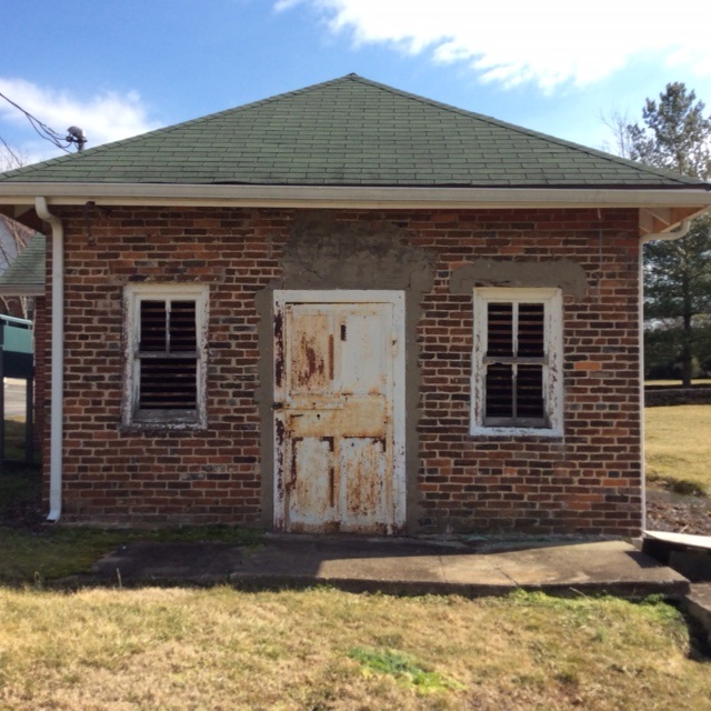
Old Jail in Stamping Ground
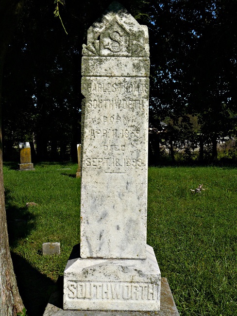
The town marshal Charles Duke, was killed while on duty in 1899. He is the only officer to have perished in the line of duty in Stamping Ground. His grave is located at the following coordinates N38 16.281 W084 41.033 .The New York Times published the events on September 20, 1899 (see below).
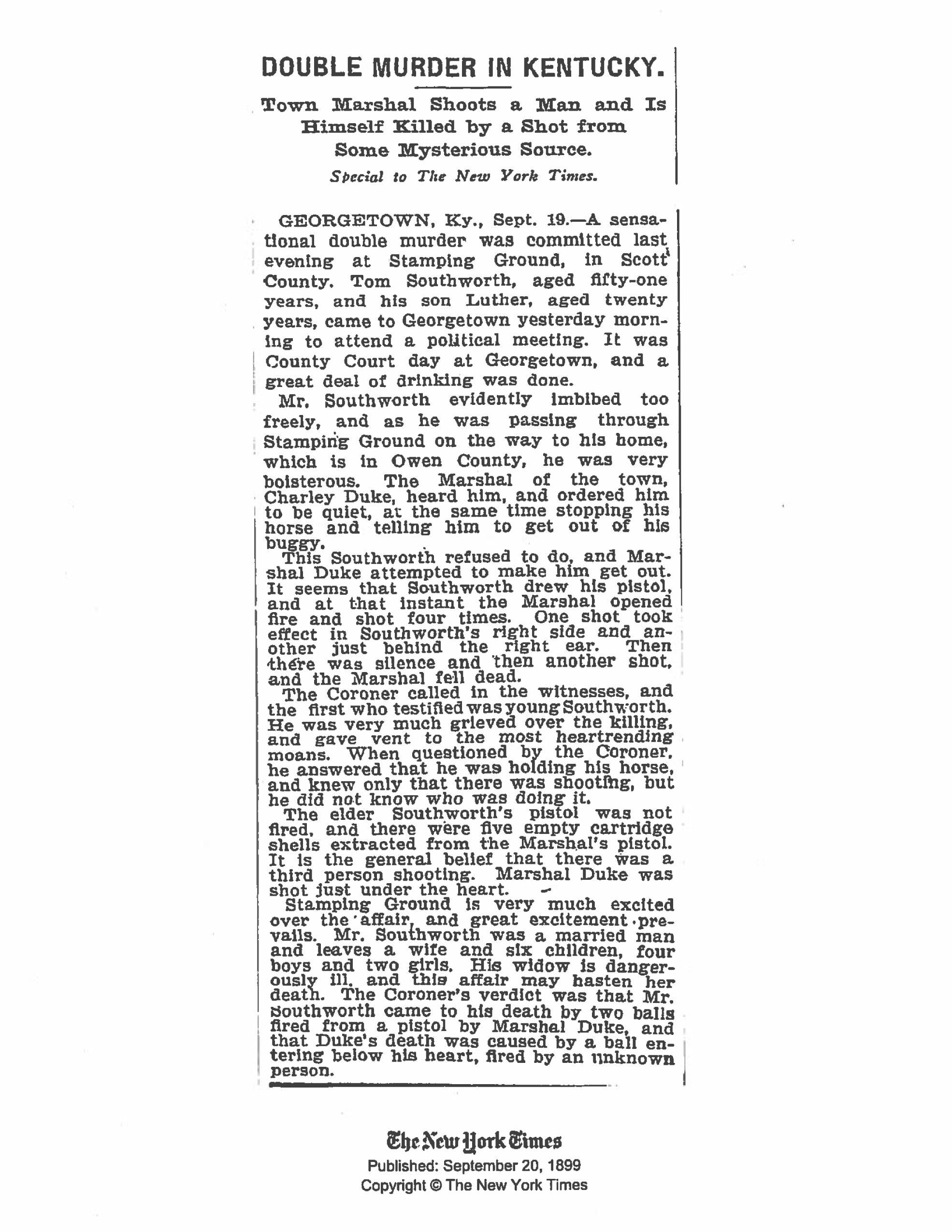
Marshal Charles Richard Duke is buried in Stamping Ground Baptist Cemetery (KSQ#235).

Charles Thomas (Tom) Southworth is buried in Beechwood Cemetery (KSQ#223) on Route 227 in south Owen County.
Proceed to Stage #3 located at N38 16.260 W084 41.275. Buffalo Springs at Stamping Ground was the first settlement of the county. Large herds of buffalo that wandered the area grazing on the rich grasses and native cane would congregate at the salt springs to drink the water. Local residents and industry utilized the spring. A tanyard operated in Stamping Ground as early as 1814, and in 1869 a whiskey distillery opened on the site. In late 1934 the new Buffalo Springs Distillery Company expanded their operations and obtained rights to Buffalo Springs as a water source from the town of Stamping Ground, In 1941 opened. Later owners were Stagg Co. (1941) and Schenley Distillery (1951). The distillery ceased operations in 1968. Water continues to flow from the spring here.
 Buffalo Springs
Proceed to Stage #4 located at N38 16.339 W084 41.269. The site of the former Buffalo Springs Distillery was first a tannery as early as 1814. Following this, two woolen mills were established in the area. In 1860, a firm purchased one of the woolen mill buildings and converted it into a distillery. The operation changed hands a number of times before coming into local ownership in the early twentieth century. Prohibition put a moratorium on the distillery, but it reopened in 1934, when the amendment was repealed. Buffalo Springs Distilling Company expanded their operations and obtained rights to nearby Buffalo Springs as a water source from the town of Stamping Ground. In 1941, the plant was sold to the George T. Stagg Company, who owned it for ten years before selling to Schenely Distilleries, Incorporated. The distillery ceased operations in 1968, and in 1973, Stamping Ground purchased the property. In 1974, a tornado damaged many of the property's buildings and the remaining distillery buildings were razed in 2007.
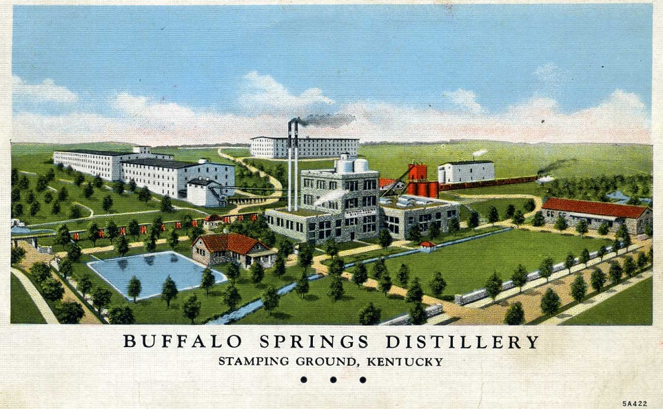
Buffalo Springs Distilling Company
Proceed to Stage #5 located at N38 16.340 W084 41.270 . This dry laid stone wall is considered to be of unusual height as is evident from the majority of stone fences seen throughout the rest of the Bluegrass region Prior to the devastating tornado that destroyed much of Stamping Ground on April 4, 1974, the steps at the far north end of the wall led to a thin two-story structure. The downstairs section of the residence housed a gun shop and the owners lived in the upstairs section.
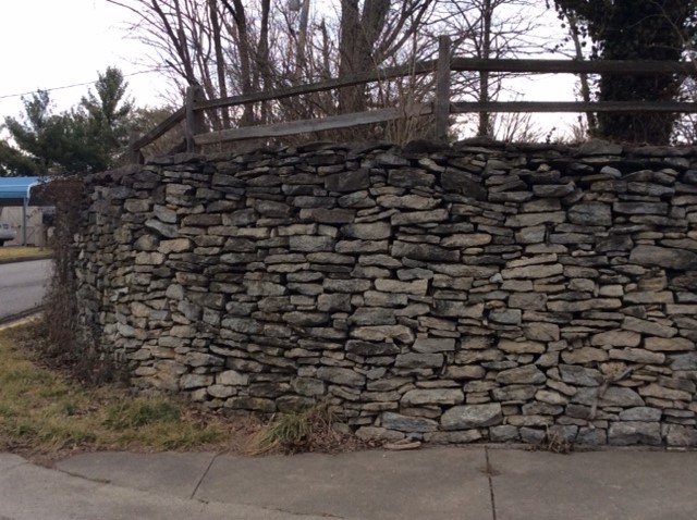
Dry Laid Stone Wall
To solve for ABC DEF get the information from each stage as follows:
Stage 1 A = number of down spouts on building plus 1.
Stage 2 B = number of rusted brace supports on the end of building facing parks parking lot minus 3.
Stage 3 C = Number of vertical bars on door at springs minus 2.
Stage 4 DE = Take the 1st 2 digits of the house number and subtract 11.
Stage 5 F = Number of windows on front of house including the dormer minus 4. Do not count the door.
Now you may proceed to the final located at N38 16.ABC W084 41.DEF
This geocache is one of 10 geocaches along the Historic Buffalo Geotrail. Passports are to be given out at the June 4, 2016 Historic Buffalo Geotrail event. Geocachers will visit all 10 geocaches along the trail and stamp the corresponding block on the passport and turn it in for a prize as supplies last. Passports will be available outside at the designated Historic Buffalo Geotrail passport box on the front porch of Stamping Ground City Hall, 3374 Main Street, Stamping Ground, Kentucky. Completed passports can be turned in here as well.
Please remember to leave the designated stamp and ink pad inside of the geocache containers!