①The earthquake is generated frequently in Japan. (Actually, The earthquake was generatedas in Fukuoka-City at yesterday(2016.3.5), an earthquake of seismic intensity [3].
②In fact, It is extremely significant to know that the trace of the earthquake exists close to our lived.
③There is not it, in this cache at scenery surprised at and an opportunity to see a rare thing, but you may learn about an earthquake more by this cache.
日向峠断層は福岡市内にある断層です。
そしてこのcacheを通して「地震と断層の関係」について学んでみましょう。
The Hinata-Touge Fault is a fault in Fukuoka City.
We will learn about "relations of an earthquake and the fault" through this fault.
出典:気象庁HP、なお一部加工しています。
Source: Japan Meteorological Agency website (URL of relevant page)
1.地震 (Earthquake)
地震は地下で起きる岩盤の「ずれ」により発生する現象です。
では、なぜこのような現象が起き るのでしょうか。硬い物に何らかの力がかかり、それに耐えられなくなると、ひびが入ります。地 下でも同じように岩盤に力がかかっており、それに耐えられなくなったときに地震が起こる(岩盤がずれる)のです。
このずれる現象を「断層」活動といい、そのずれた衝撃が震動として地面に伝わったものが地震です。すなわち、断層は地震の痕跡なのです。
The earthquake is a phenomenon to occur by "a gap" of bedrock rising in a basement.
Then why will such a phenomenon happen? Some kind of power appears to the hard thing, and it cracks when I become not able to bear it. Power depends on bedrock in the same way in the basement and is one of which has an earthquake when I became not able to bear it (bedrock slips off). And underground bedrock calls "the state that I drag and work, and discrepancy produced" "the dislocation". In other words, the dislocation is a trace of the earthquakes.
では、どうして地下に力がかかっているのでしょうか。これは、「プレートテクトニクス」という説 で説明されます。
Then, why will power appear underground ? This is explained by an opinion called "The Plate Tectonics".

地球は、中心から、核(内核、外核)、マントル(下部マントル、上部マントル)、地殻という層構造に なっていると考えられています。このうち「地殻」と上部マントルの地殻に近いところは硬い板状の 岩盤となっており、これを「プレート」と呼びます。地球の表面は十数枚のプレートに覆われています。 (左図:地球の内部構造)
It is thought that the earth becomes a nuclear (Inner Core, Outer Core) mantle (Lower Part Mantle, Upper Part Mantle), the laminar structure called the earth crust from the center. Of these, it becomes hard board-formed bedrock, and the place that is near to "The Earth Crust" and the earth crust of the upper part mantle calls this with "Plate". The surface of the earth is covered to the plate of ten several pieces. (a left-hand figure: Internal structure of the earth)

日本周辺では、海のプレートである太平洋プレート、フィリピン海プレートが、陸のプレート (北米プレートやユーラシアプレート)の方へ1年あたり数cm の速度で動いており、陸のプレー トの下に沈み込んでいます。このため、日本周辺では、複数のプレートによって複雑な力がかかっ ており、世界でも有数の地震多発地帯となっています。(左図:マントルとプレートの動き)
Around Japan, the Pacific plate and Philippine Sea plate which are "The Plate Of The Sea", move at speed of few cm per one year towards "The Plate Of The Land (North American Plate and Eurasia plate)" and sink under "The Plate Of The Land". Therefore, around Japan, complicated power appears by plural plates, and it is with an eminent earthquake-prone zone in the world.(a figure of leaning to the left: Movement of a mantle and the plate)


日本周辺では、海のプレートが沈み込むときに陸のプレートを地下へ引きずり込んでいきます。陸のプレートが引きずりに耐えられなくなり、跳ね上げられるように起こるのが①プレート境界の地 震です。
プレート内部に力が加わって発生する地震が、プレート内の地震です。プレート内の地震には、 ②沈み込むプレート内の地震と③陸のプレートの浅いところで発生する地震(陸域の浅い地震)があります。
陸域の浅い地震は、プレート境界で発生する地震に比べると規模が小さい地震が多いですが、 人間の居住地域に近いところで発生するため、大きな被害を伴うことがあります。
Around Japan, When the plate of the sea sinks, it drag a plate of the land into the basement. A plate of the land becomes not able to bear it to drag it, and it is ①"Interplate Earthquakes" that have so that it jump and am put up.
An earthquake that power increases in the plate inside and is generated is the earthquake in the plate. For the earthquake in the plate, there are two type ,②"Intraplate Earthquakes" and ③"Shallow Crustal Earthquakes".
"Shallow Crustal Earthquakes" are many earthquakes that a scale is smaller than "Interplate Earthquakes", but may be accompanied by big damage to occur in the place where the human residence area is near.
ここまで地震の発生メカニズムについて学んできましたが、次に断層の種類について学んでみましょう。
2.断層 (fault)
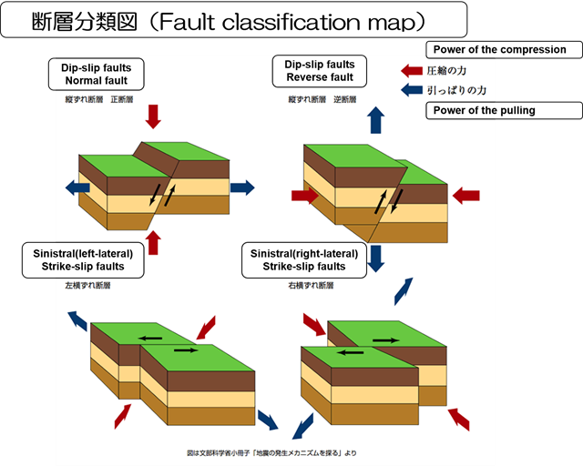
地層のずれである断層は、そのずれ方によって4つに分類されます。
We learned about the earthquake mechanism, next Let's learn about fault classification.The fault which is the gap of the stratum is classified in four by the gap variation.
出典:文部科学省「地震の発生メカニズムを探る」
Source: Japan Ministry of Education, Culture, Sports, Science and Technology
断層面が傾いている場合、両側の岩盤のうち、浅い側を「上盤」、深い側を「下盤」と呼びます。断層面を境として両側のブロックが上下方向に動くときを「縦ずれ断層」と呼びます。「縦ずれ断層」のうち、上盤側がずり下がる場合を「正断層」、のし上がる場合を「逆断層」と言います。
一方,両側のブロックが水平方向に動くときは「横ずれ断層」と呼び、断層線に向かって相手側のブロックが右に動く場合を「右横ずれ断層」、左に動く場合を「左横ずれ断層」と言います。
日本の内陸地震では、中部地方から西日本にかけては横ずれ断層型が多く、東北地方などの北日本では逆断層型が多いと言われています。
実際の断層を見ると、上記のように純粋に「縦ずれ断層」、「横ずれ断層」と呼べるものはまれで、多くのものは斜めにずれています。
When a fault plane inclines, among the bedrock of both sides, We call "a hanging wall", a deep side "a footwall" in a shallow side. We call time when the block of both sides moves the fault plane in the top and bottom direction as a boundary "Dip-slip faults". Among "Dip-slip faults" We say , a case to push its way up to in the case is "normal fault", other the hanging wall side slips down is "reverse fault". On the other hand, when the block of both sides works horizontally, I call it with "Strike-slip faults" and call a case to move the case that the block of the counterpart moves to the right towards a fault line to "Sinistral (right-rateral) Strike-slip faults", the left "Sinistral (left-rareral) Strike-slip faults". By the inland earthquake of Japan, a lot of "Strike-slip faults" types are existed in the West Japan from the Chubu District, and "reverse fault"types are existed in North Japan of the Tohoku districts. "Dip-slip faults", the thing to be able to call "Strike-slip faults" are rare, and many things are diagonally purely as above when they watch real dislocation.
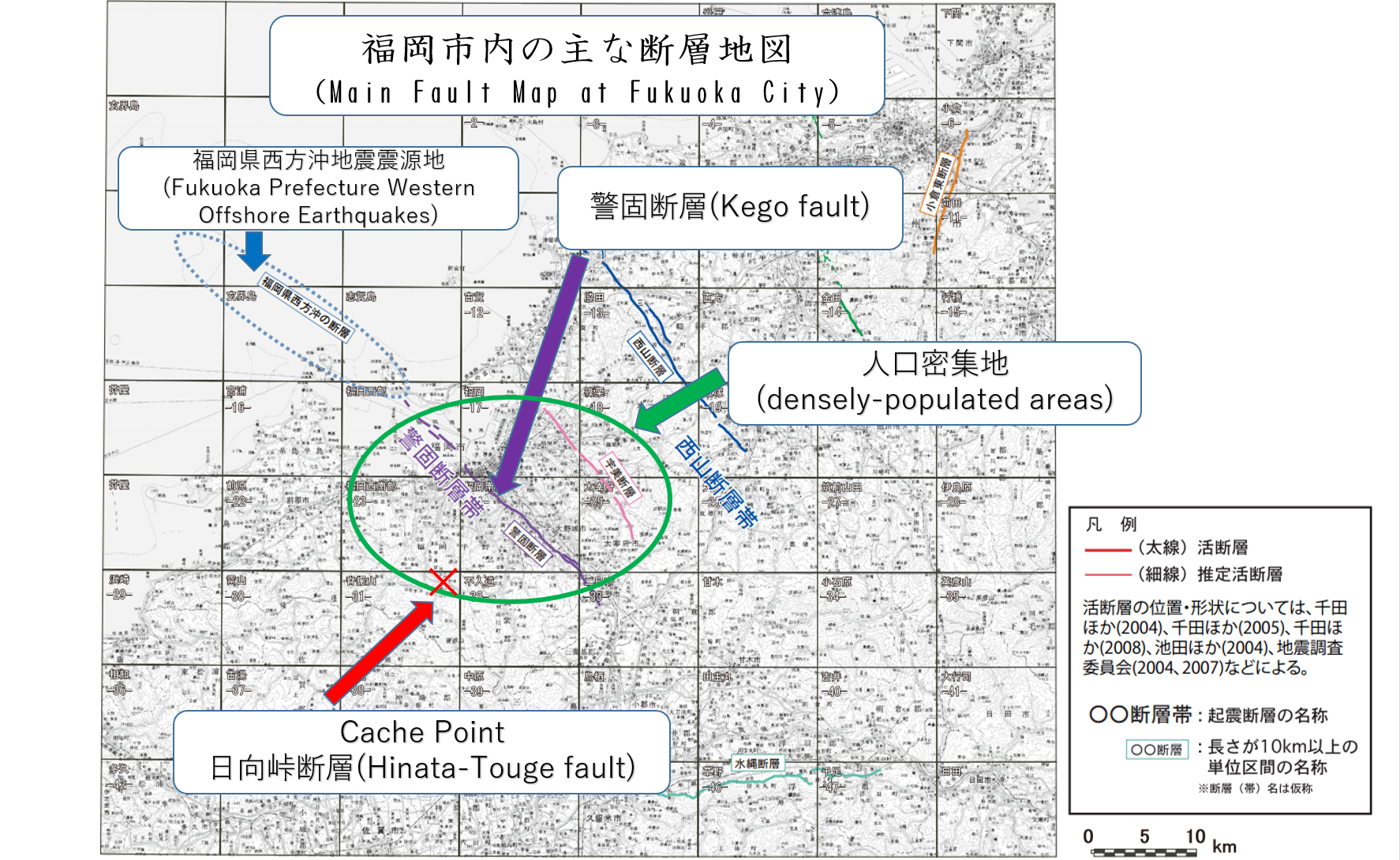
3.福岡市内の断層 (Fault in Fukuoka City)
福岡市内には「③陸のプレートの浅いところで発生する地震(陸域の浅い地震)」の発生原因となる断層がいくつか確認されています。日向峠断層もその内の一つです。他には「警固断層」があります。この断層は市街地中心部にあるため、建物や道路で埋め尽くされているため断層面を見ることができません。
断層の中で「警固断層」や「日向峠断層」のように、過去に繰り返し活動し、将来も活動することが推定される断層のことを「活断層」といいます。
2005年3月20日、警固断層の延長線上にある福岡市沖の海底を震源とするマグニチュード7.0の地震が発生し、死者1名、負傷者約1,200名、住家全壊約140棟の大きな被害が発生した。この地震には「福岡県北西沖の断層」(仮称)で発生したと考えられている。
Some fault where it becomes the origin of "Shallow Crustal Earthquakes" in Fukuoka City. The Hinata-Touge Fault is one of the existing fault in Fukuoka City. There is "Kego Fault" elsewhere in Fukuoka City. Because there is it in the downtown area center, "Kego Fatlt" cannot watch a fault plane to be filled on a building and a road.
I am active repeatedly like "defense dislocation" and "Hiuga Pass dislocation" in dislocation in the past, and it says estimated dislocation with "an active fault" to be active in the future.
A 7.0-magnitude earthquake to assume the bottom of the sea of a certain Fukuoka City offing the seismic center on an extension line of "Kego Fault" on 20 March , 2005 occurred, and one dead person, injured person approximately 1,200, big damage of approximately 140 dwelling house complete destruction occurred. It is thought that it occurred with "Fault of the Fukuoka northwest offing(tentative name) " for this earthquake.
出典:地震調査研究推進本部「九州北部地域における活断層の長期評価」
Source: The Headquarters For Earthquake Research Promotion
4.日向峠断層 (Hinata-Touge Fault)
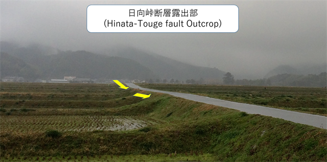
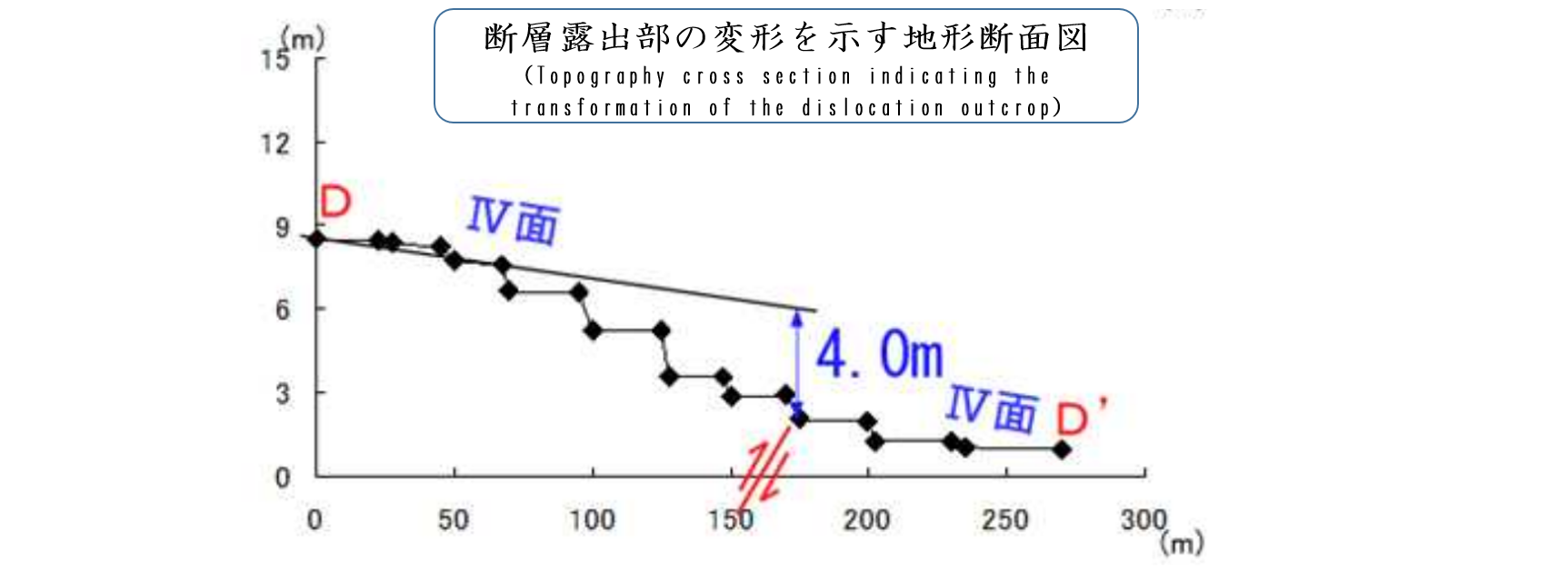
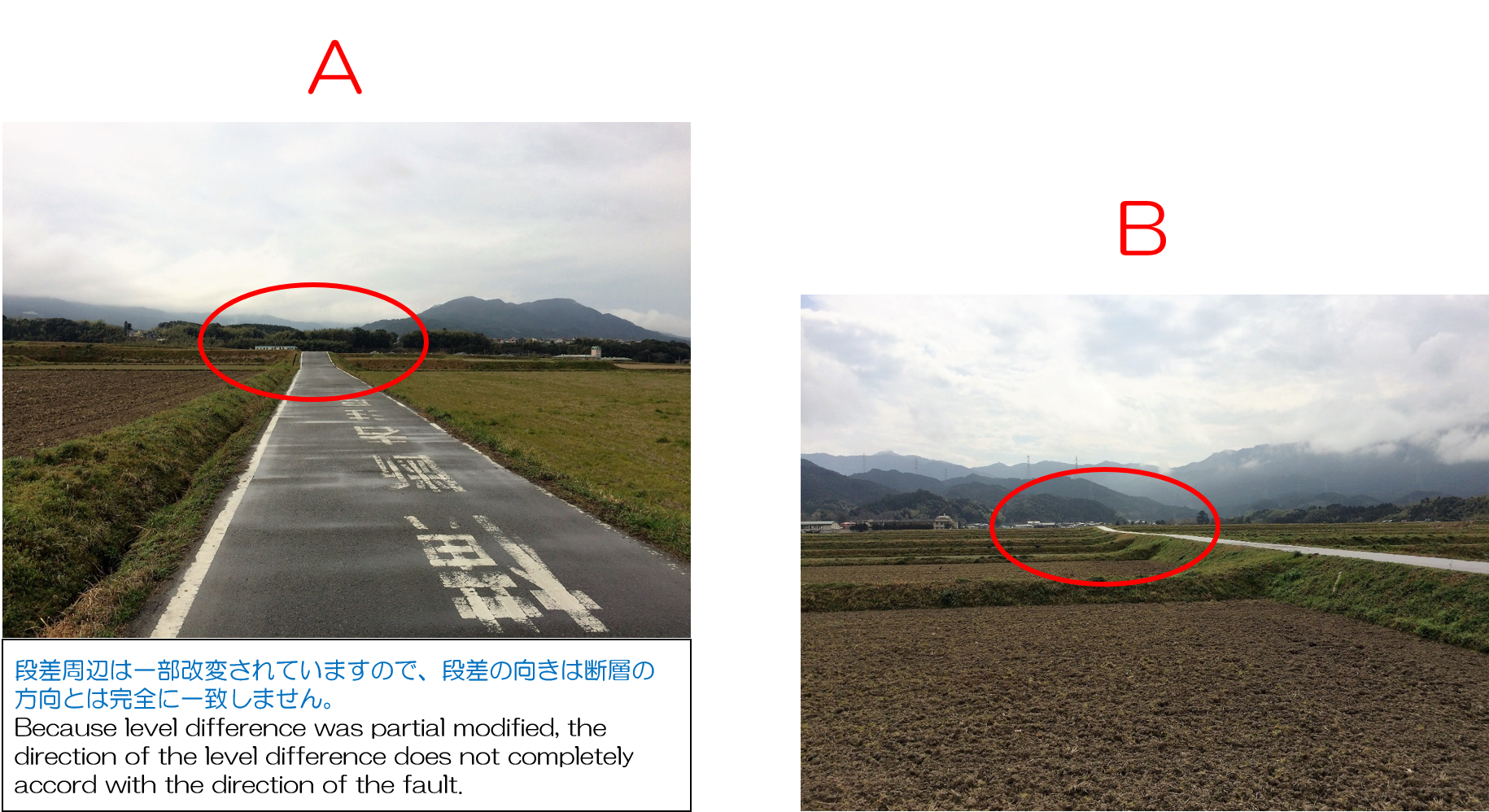
各種調査の結果、日向峠断層は「横ずれ断層」であることが分かっていますが、一部では「隆起」を伴っています。そして、公開座標周辺ではその「隆起」を確認できます。市街地の人口密集地近くで断層を確認できる場所は少なく貴重です。
Hinata-Touge fault is "Sinistral Strike-slip faults", but takes "southwestern side upheaval ingredient" partly. And We can confirm the "upheaval" at a public coordinate spot.The population crowd place place that can watch fault near of the downtown area is extremely valuable. (blue frame part of the chart below)
公開座標周辺で露出部を見つけてよく観察してください。僅かながら途中で傾斜が変化していることが分かります。(下図・写真参照)
Would You stand at the point, and, please observe this outcrop well. You understand that a slant changes a little on the way. (cf. chart below)
出典:地震調査研究推進本部「日向峠-小笠木峠断層帯の長期評価都市圏活断層図」
1. 以下のTASKを実行してください。
2.キャッシュ名と解答をキャッシュオーナー(hikohohodemi)にメールしてください。
3. 答えはログに記入しないでください。
4.メールを送信したらファウンドログを上げてください。私の承認を待つ必要はありません。
TASK 1
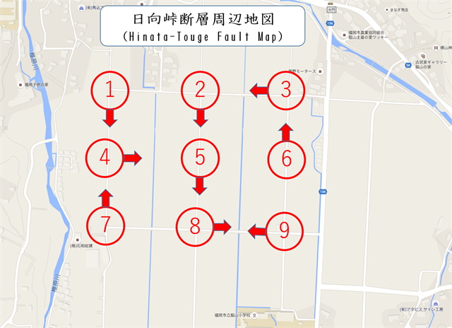
次の2つの写真は ”どの地点から" 撮影したものでしょうか?
(〇印の段差が断層です)
下の地図の中から番号で解答してください。 例)A-10、B-11
公開座標は地点「 7 」です。
TASK 2
2つの段差位置から、この断層はどの方位に連続していると考えますか?
方角の記号を解答ください。例)1-2 or 3-4
1. 北東 2. 北西 3. 南東 4. 南西
TASK 3
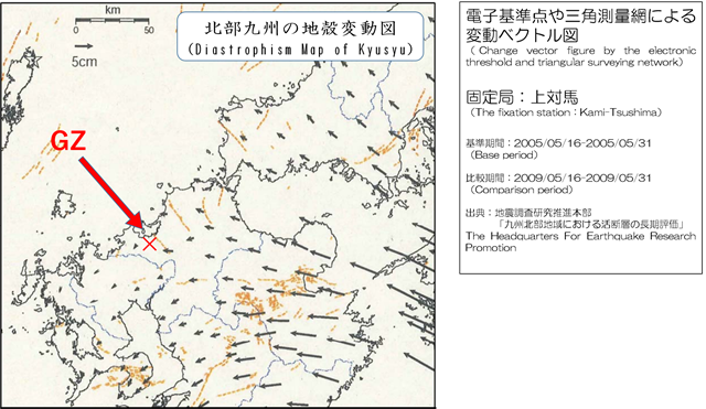
日向峠断層は「右横ずれ断層」でしょうか?それとも「左横ずれ断層」でしょうか?
あなたが推論する根拠を示してください。
(解答に当たっては下の図を参考にしてください)
OPTION
GZで日向峠断層とあなた、またはあなたのGPS機器の写真を撮り、ログにアップロードしてください。
1. Please carry out following TASK.
2. Please send e-mail this cache name and the answer to following questions to cache owner.(hikohohodemi)
3. Do not include this answer in your on-line log.
4. You do not need to wait for confirmation from me before posting online.
TASK 1
Do you think where photography place of next two photographs are taken ?
Please answer alphabet character with a number from under the map. (the level difference in the "◯"mark is fault). Example) A-10, B-11
The public coordinate is spot " 7".
TASK 2
From two level difference positions, which direction do you think this fault to continue to?
Please answer the sign of the direction. Example) 1-2 or 3-4
1. Northeast 2. Northwest 3. Southeast 4. Southwest
TASK 3
Do you think that this fault is "Sinstral (right-lateral) Strike-slip faults ?" or "Sinstral (left-lateral) Strike-slip faults ?" Please explain your thoughts. Please refer to a lower map in your answer.
OPTION
Please upload the photo(fault with you or your GPSr in GZ) to the log.
このEarthcache の制作にあたりご協力いただいた"Kyamacyanさん"、"moujiさん"、"zizi-jpさん"に感謝申しあげます。
Special Thanks : "Kyamacyan-san"、"mouji-san"、"zizi-jp-san"