I must begin by thanking Felicity Davies-Birks - Countryside Ranger at Gloucester City Council, Toby Willis, Project Manager, Environment Agency (West Midlands), The British Hydrological Society and Mother Nature who has played a more than vital role in enriching, enhancing and embellishing this wonderful example of "Man Made Earth Science".
It is also incumbent upon me to remind you that any visit to this area must be treated with due respect and consideration. It is a great place to spend some time watching and listening - to enjoy a wonderful space and place. Please do not leave any rubbish or extraneous materials behind; whatever came with you, please take it away.
Thank you.
**************************************
I know there is quite a bit to read, but there's a lot going on. Please try to work your way through it; besides, it should help with some of the responses.
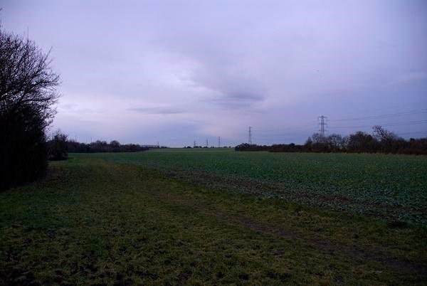
The turnip field before work started taken 2010 - this end is now occupied by the Sump/Reservoir Pool.
(Picture by Raggeh)
**************************************
Brief Overview as to the origins of the Horsbere Flood Alleviation Scheme.
The background image sums up the reason for Horsebere - in particular, the torrential rain in July 2007. Although the problem of flooding in the area certainly preceded and succeeded this; however it was deluge in 2007 which formed a turning point.
The whole raison d'etre of Horsbere is Flood Alleviation - it is a contentious issue that the flooding in Longlevens/Longford was exacerbated by excessive residential development on the flood plain, causing a significant increase in drainage into Horsbere Brook, at a point where the water volume was already high.
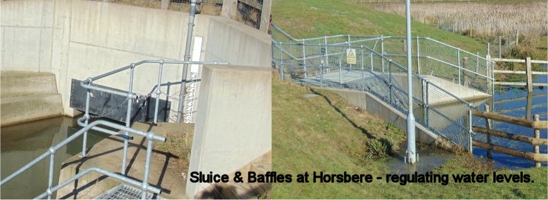
The 'Nuts and Bolts' of the Flood Alleviation Scheme.
For me, the story starts in 2002 when a walk around the area meant a walk around a turnip field, which often smelt rotten. There was some wildlife to see and lovely blackberries to pick when in season. It made for a relatively pleasant walk, although the thick glutinous clayey soil often made life difficult.
Then 2007 happened, and a strangely perverse way, some real good came out of it; they decided to create Horsbere - goodbye turnips!
The source of Horsbere is right up in the lovely Cooper's Hill Woods, where it bubbles out of a limestone fissure just below the Cotswold Way. It's a beautiful spot and the stream looks so young and innocent, but it has an interesting journey ahead. For a large part of its path, the brook run is narrow, steep-sided and the stream-bed is stony.
**************************************
The flood storage area was created by excavating over 120,000 cubic metres of earth, the majority of which was used to form a flood embankment and to profile the existing hillsides and create a natural looking landscape, enhancing the local area.
The aim was to produce a landscape and habitat plan for the 20 hectare site, which would benefit the environment and the wider community to create a wildlife and amenity area with grazing marsh, reed beds, ponds and native woodland.
The creation of Horsbere relied upon extensive Geological and Topographical surveys. The primary and initial assessment focused on the Pedology of the area.
The surface layer consisted mainly of lias consisting of mudstone, sandstone, siltstone and limestone. However there was a significant amount of moisture-retentive lias clay, causing a hydrological imbalance - flooding.
When digging out the ponds a large number of "Common" fossils including belemnites, bivalves and brachiopods were exposed. These still surface on the large 'spoil mound'.
Horsbere is man made, but, as I have previously alluded to; it was created locally; for the most part it is 'home-grown' and because of this its Geological and Pedological structure was so important. Fundamentally, it about water management and control by means of landscape restructuring.
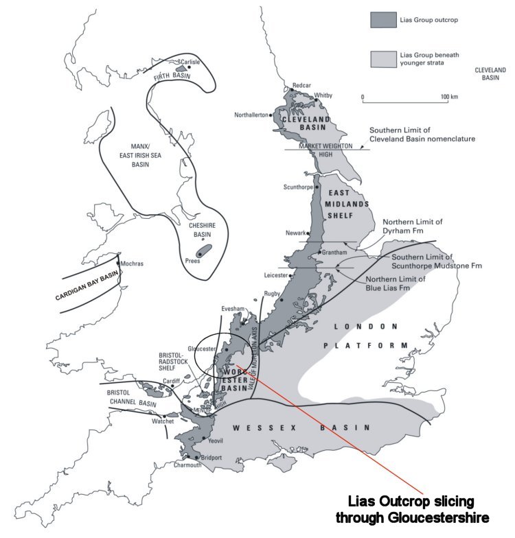
Taking it down to grass roots - no pun intended; it is about Blue Lias and this crops up all the time in 'local' Geology, because it is the key geological attribute.
Lias is a name, which dates back to some of the oldest works of geology, signifying the earliest of the three sub-divisions of the Jurassic Period. In Britain, the Lias Group encompasses an important group of geological materials. It has been the working medium of major engineering projects, industrial exploitation, and scientific research.
Now the last thing I want is to baffle people with pretentious science, I'm no Geologist and most Geocachers only have a very superficial understanding of the subject. But I think it is important to appreciate the nature of Lias.
It comprises those predominantly clay-rich sediments of latest Triassic and Early Jurassic age found in and around the United Kingdom, deposited between 180 and 205 million years ago; extending in a continuous band from the coast of Dorset through to Yorkshire, with outlying areas in Somerset and South Wales.
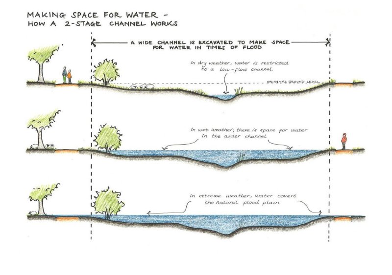
A very simple representation of how a system like Horsbere works.
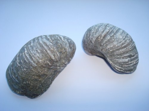
Gryphaea, common name Devil's toenails - as turned up at Horsbere.
Gryphaea, common name Devil's toenails, (quite simply extinct oysters), were turned up in their dozens during the Horsbere excavations
They range from the Triassic, Tertiary and Jurassic periods and are possible evidence of the 'shape' of this landscape millions of years ago.
It could be determined that Horsbere encompasses The Pedosphere, The Hydrosphere and The Biosphere in terms of Earth Science.
Horsbere is evolving, growing, developing into a dynamic habitat. It's geological, hydrological and topographical structure has been transformed.
**************************************
Having given you a very basic outline, and, hopefully, enough information; I now ask to consider the "whys and wherefores" of Horsbere.
1) Looking at the landscape - consider and suggest why the Horsbere area was considered the best location to construction a Flood Alleviation Scheme. Here, it is worth looking at the broader and more distant landscape not just the scheme itself. From your observations, why do you think it was chosen?
2) Horsbere Brook doesn't look as if it would cause such catastrophic problems; it usually appears quite benign. Why, in your opinion, or judgment, could it be that this seemingly unassuming waterway had such an impact as it nears its journeys end at the River Severn?
3) What might the presence of Belemites suggest in the Geological history of the area. How do you think they came to be there in such numbers?
4) I have described the importance and influence of Pedology and Topography, so here's a nice little Google search for you. Briefly, in your own words, describe what these are.
5) Why do you think the "mound" on the western side of the site is important; what is its significance and purpose? Here, I strongly recommend an 'exploration' of the mound; there are several trails covering it.
6) The landscaping of Horsbere has had a dramatic impact on the wildlife. What do you think makes it such a "magnet" for wildlife?
7) As you walk around Horsbere, it should be clear that a variety of diverse habitats have been established. From your observations, how do you think these habitats have been created and/or formed; what 'element' is key to their formation.
8) Send me the full inscription engraved on the bench (Roger's Bench) at/near the published coordinates.
Send you responses etc. to:
tabithaswell@gmail.com
(NB - please do not post your log until I have cleared your responses.)
I appreciate that you will want to log the cache as soon as possible, so you can help by making sure your responses are clear, considered and pertinent.
Take your time when composing your observations!
It may take a few days for me to respond, so please be patient; I WILL respond.
NB - More than anything - I hope you enjoyed your visit to Horsbere. Thank you for doing this Earth Cache and for taking the time and trouble to respond to all my questions.
Most important of all, I sincerely hope that you have learnt something, that by doing this you have a greater understanding of what has happened at Horsbere.
The area is still evolving; new plantations are being established and the ecology continues to develop. Horsbere is not yet a 'designated Reserve', but I feel that is now almost inevitable.
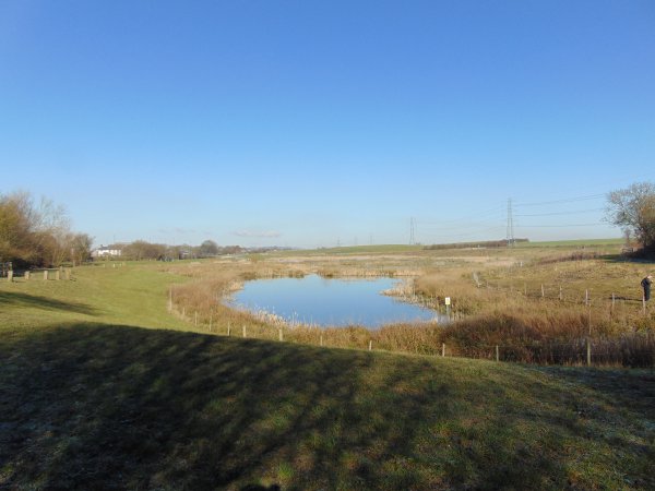
February 2016 - Horsbere from roughly the same spot as the top image.