What makes Tampa Bay Tampa Bay?
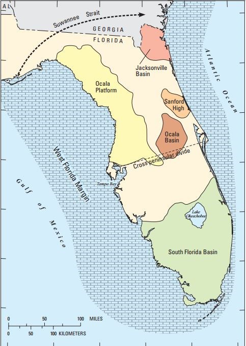
Tampa Bay has an unusual geologic history when compared to many other estuaries in the eastern US. It lies near the center of the carbonate Florida Platform and is associated with a buried “shelf valley system” that formed in the early Miocene age (20 million years ago). Since that time the area has been subject to substantial fluctuations in sea level and alternating periods of sediment deposition and removal. These events have produced a complex distribution of siliciclastic and carbonate-based sediments within the bay, its associated barrier islands and the inner Florida shelf. Sinkholes and other karst features in the underlying carbonate strata, which are common throughout the west-central Florida region, have been important factors underlying the development of Tampa Bay as well as Charlotte Harbor, a geologically similar estuary located about 100 miles to the south of Tampa Bay. In the case of Tampa Bay, the underlying shelf valley system consists of multiple karst controlled sub-basins that have been filled by sediments.
The thick carbonate bedrock of the Florida Platform is of mid-Jurassic (about 170 million years ago) to Miocene age with a karst surface that contains numerous sinkholes, folds, sags and warps. About four to six million years ago, the wrinkled shallow bottom was topped by a massive transport of quartz sand that originated 1000 miles north. The Florida Platform is covered by a comparatively thin mantle of quartz sand and other sediments. The sand originated in silicate-rich bedrock in the Appalachian Mountains and Piedmont area in what is now the eastern US mid-Atlantic region. How the sand got here is still not very well understood. But millions of years after it arrived the ancient sand shipment was remobilized locally, probably in very wet years by river flow and it flowed into and filled in the bottom of Tampa Bay.
The rocks that weathered to produce the sand were already hundred of millions of years old. It appears that exposed silicate-rich bedrock, chemically weathered, arrived from the north through multiple sources and most likely through runoff into streams and rivers running from the mountains to the coast. The sediment flow was deposited in the Georgia channel system and during times when sea levels were high, the sand eventually arrived in Tampa, adding to the geological features of Tampa Bay’s basin, already millions of years old.
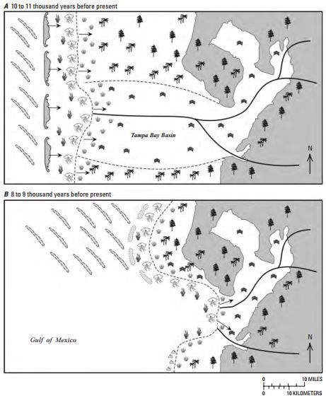
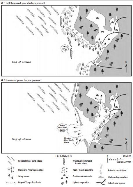
Near the end of the last ice age, approximately 20 thousand years ago, glaciers held a large percentage of the Earth’s water and global sea level was about 122 meters lower than it is today. At that time the Gulf coast of west Central Florida would have been about 120 miles west of its current position and the area that is now Tampa Bay was near the center of the Florida Peninsula. As the ice began to melt during the initial warming that ended the most recent glacial period, about 17,000 years ago, the gulf shoreline migrated inland as sea levels rose and the physiography of the Tampa Bay region evolved into the configuration we see today.
Please NOTE: Vinoy Park is a City of St. Petersburg Park and is free to the public, however when there are events (Rib Fest, etc.) scheduled in the park, there may be an admittance fee.
http://pubs.usgs.gov/circ/1348/pdf/Chapter%203_37-62.pdf
http://phys.org/news/2006-11-oceanographers-tampa-bay.html
To log a find for this EarthCache, you will need to answer the following questions. Email the answers to furshore at the above address.
1. Using your GPS device, estimate the width of Tampa Bay from ground zero to the smoke stacks across the bay.
2. In your own words, describe what you think is at the bottom of Tampa Bay.
3. Estimate the height of the retaining wall above the water level.
4. Describe the clarity of the water at the retaining wall.
5. Do you think Tampa Bay was man-made and explain your answer.
6. Pictures are welcome.