Türkçe açıklama için sayfayı aşağıya kaydırın...
[ENG]
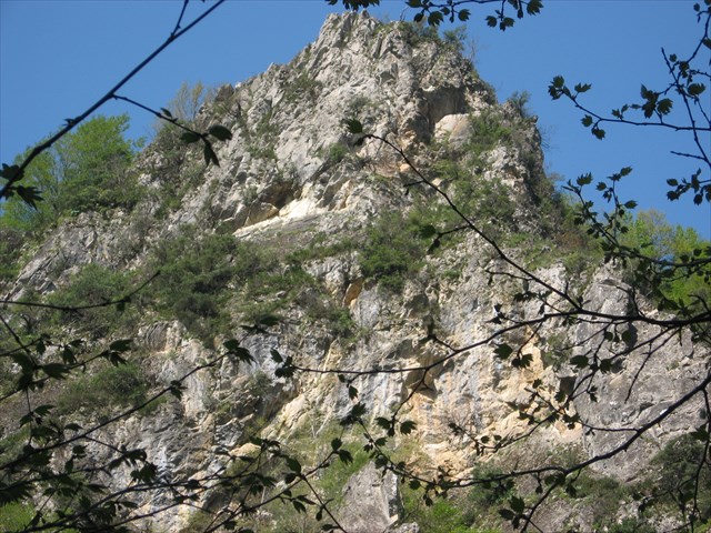
Serindere is one of the valleys feeding the Yuvacık Dam which is located SE of İzmit (Kocaeli).
Accessing Serindere may be difficult for those who are unfamiliar with the area. It is located southeast of Kocaeli, about 19 km drive from Yuvacık town. Asphalt roads are available up to Örnek town. I suggest you exit the highway through East Izmit booths, then continue on the road to Gölcük and follow Yuvacık signs after Başiskele intersection. Once you arrive at the dam, cross over it; it is allowed and free of charge. Following the road that goes through the dam, you’ll pass by the towns of Camidüzü and then Örnek. You can enter the gorge from Örnek town. If you’d like to take the longer route, do not cross over the dam and drive around it, passing the towns of Aksığın, Tepecik, Serindere and then finally Örnek. In either case, you will need to reach Yuvacık and then the dam area.

At the entrance of the gorge, there is a nice fish restaurant where you can park your car and enjoy the food.
Although you may go further with your car, I suggest you leave it there and enjoy the walk through the gorge.
The route goes straight for some time and then divides into two branches. The path to the left will lead you to rough patches that go up to higher parts while the path to the right will lead you to the Serindere gorge through the creek. It is also one of the favorite paths of local hikers.
Geology of Serindere
Although this canyon is not a part of the Armutlu peninsula in official maps and is in fact far away from the peninsula, it may be considered a part of Armutlu in terms of geological consistency. The area in question experienced intense tectonic deformation just like the rest of the peninsula. Units have metamorphized.
Armutlu peninsula has been subjected to research by numerous local and foreign scientists since the 1800s due to its geological and geographic position. Studies regarding tectonics and stratigraphy of the region are aimed to contribute to the paleogeographic evolution of the region.
5 different geological units can be observed around the canyon. They are, from the bottom to top; schist, marble, ophiolite, clayey units, and volcanic units respectfully.
Schists which are located in the foundation of this metamorphic series start with mica schist and its derived types and end with marbles. This whole unit has been declared to be 300 million years old (permo-carboniferous) by Akartuna (1968). This unit is included in the İznik metamorphics.
The ophiolitic unit is tectonically located in the metamorphic basement. The thickness of the unit exceeds 20 meters in places.
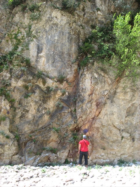
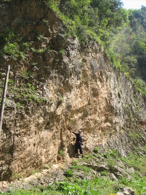
The fault plane is the planar (flat) surface along which there is a slip during an earthquake.
Serindere Fault is an oblique fault. It continues along the gorge, which you can see clearly the fault surface in the entrance of the gorge. Generally, fault slope is high (750-800) and it becomes a vertical fault in places. The main direction of the fault is approximately N700W.
Marbles: The metamorphic rock which consists of recrystallization of calcite and/or dolomitic rocks as the result of metamorphism. The main mineral it contains is calcite, which is at least %90. Also, it may contain silica, mica, ferro oxides, organic materials, etc. in small quantities. According to other materials that it contains (according to quantities and combinations) it can be white, pink, black, red, etc.
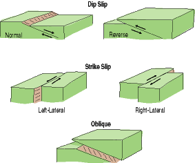
(Fault types)
(Fault Plane-Serindere Fault)
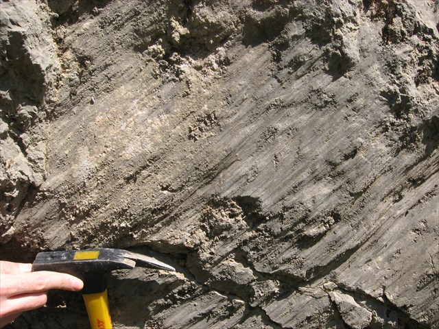
(Fault Plane-Serindere Fault)
To log this Earthcache:
Please answer these questions and send them to me only via message. If you log this cache before you send the correct answers your log will be deleted. All Geocachers should submit their own answers. Copy-paste answers will not be accepted.
Questions:
-
Of which rock is the gorge mainly made up?
-
What color are the marbles here? According to its color, what kind of minor elements may exist in these marbles?
-
Right next to the entrance of the tunnel inside the canyon you will find a fault plane. What is the width and length of that fault plane? Touch the fault plane and describe the surface.
- Please take a selfie while you exploring the area and attach it to your logs. (This task is not mandatory it is optional)
I hope you will enjoy this Earthcache
*******************
*******************
*******************
[TR]
Serindere İzmit (Kocaeli)’nin güney-doğusunda bulunan ve Yuvacık Barajını besleyen vadilerden birisidir.
Ulaşım bölgeyi bilmeyenler için biraz karmaşık olabilir. Yuvacık beldesine 19 km.’lik araç yolu mesafesinde bulunur. Örnek Köyüne kadar asfalt yol bulunmaktadır. Şehirdışından gelenlere otoyolun Doğu İzmit gişelerinden çıkıp Gölcük yolunu takip etmelerini sonrasında Başiskele kavşağında Yuvacık tabelalarını takip etmeye başlamalarını tavsiye ederim. Başiskele kavşağından sonra Yuvacık barajını gösteren küçük tabelalar görmeye başlayacaksınız. Baraja ulaştıktan sonra barajın üzerinden karşıya geçin. (Barajın üzerinden geçmek ücretsiz ve serbest) Barajın üzerinden geçen yolu takip ederek önce Camidüzü Köyüne sonra ise Örnek Köyüne ulaşıp buradan kanyonnin girişine ulaşabilirsiniz. Eğer uzun yolu seçmek isterseniz barajın üzerinden geçmeyip baraj boyunca devam eden yolu takip ederek Aksığın, Tepecik, Serindere ve Örnekköy üzerinden buraya ulaşabilirsiniz. (Bu yolu tavsiye etmiyorum) Her iki yoluda kullanabilmek için ilk önce Yuvacık beldesine sonrada barajın bulunduğu kısma ulaşmak zorundasınız.
Kanyonun girişinde aracınızı park edebileceğiniz ve güzel yemeklerini deneyebileceğiniz bir alabalık tesisi bulunmakta. Ayrıca isterseniz bu tesiste kamp kurabileceğiniz yerler bulunmakta.
Kanyonun içinde bir süre daha araba ile gidebilecek olmanıza rağmen arabanızı girişte parketmenizi ve kanyondeki kolay yürüyüşün tadını çıkartmanızı tavsiye ederim.
Kanyon girişinden itibaren bir süre düz olarak devam etmekte sonrasında iki kola ayrılmaktadır. Sol taraf dikleşerek farklı bir kısma açılmakta, sağ taraf ise dere içerisinden Serindere Kanyonuna açılmaktadır. Bu rota doğa yürüyüşü sevenlerin favori rotalarından birisidir.
Jeoloji
Söz konusu kanyon her ne kadar siyasi haritalarda Armutlu yarımadasına dahil edilmesede ve gerçektede Armutlu yarım adasına uzak olsada jeolojik birliktelik bakımından Armutlu yarım adasına dahil edilebilir. Söz konusu bölge Armutlu yarım adasının doğu kesminde yer alıp bölgenin tamamı gibi şiddetli tektonizma etkisi altında deformasyon geçirmiştir. Birimler metamorfizma geçirmişlerdir.
Armutlu Yarımadası jeolojik ve coğrafik konumundan ötürü 1800 lü yıllardan beri yerli ve yabancı birçok bilim adamına araştırma konusu olmuştur. Özellikle bölgenin tektoniği ve stratigrafisi ile ilgili bu çalışmalar, günümüzde hala tartışmalı olan yörenin paleocoğrafik evrimine katkıda bulunmaya yöneliktir.
Kanyon civarında 5 adet ayrı jeolojik birim gözlemlenebilir. Bunlar tabandan tavana doğru sırasıyla ; şist birimi, mermerler, ofiyolitli birim, killi birim ve volkanik birimdir.
Temeli oluşturan şistler, mikaşist ve türevi kayaçlarla başlayıp üstte mermerlerle son bulur. Tüm bu birim Akartuna (1968) tarafından Permo-Karbonifer (300 milyon yıl civarı) yaşlı olarak belirtilmiştir. Bu metamorfik birim İznik metamorfiklerine dahildir.
Ofiyolitik birim metamorfik temel üzerine tektonik olarak yerleşmiştir. Birimin kalınlığı yer yer 20 metreyi geçmektedir.
Fay Aynası: deprem sırasında kaymanın gerçekleştiği (kayaçların kırıldığı) düzlemsel yüzeylerdir.
Serindere Fayı sağ yanal oblik karakterdedir. Kanyon girişinde aynası açıkça görülen fay kanyon boyunca devam eder. Genelde yüksek eğimli olan (750-800) fay yer yer düşey faya dönüşmektedir. Doğrultusu yaklaşık K700B ‘dır.
Mermerler: Metamorfizma sonucu kalkerli ve/veya dolomitik kayaçların yeniden kristallenmeleri sonucu oluşurlar. İçlerindeki esas mineral kalsittir ve genelde %90’ından fazlasını oluşturur. Aynı zamanda içinde az miktarda silika, mika, demiroksitler, organik bileşikler vb bulunabilir. İçinde bulunan diğer malzemelere göre (miktarları ve kombinasyonlarına göre) beyaz, pembe, siyah, kırmızı vb renklerde olabilir.
(Fay türleri)
(Fay Aynası-Serindere Fayı)
(Fay Aynası-Serindere Fayı)
Bu Earthcache'e kayıt girebilmek için:
Lütfen aşağıdaki soruların cevaplarını bana sadece mesaj ile gönderin. Eğer log girdiğinizde doğru cevapları atmamış olursanız logunuz silinecektir. Her oyuncu kendi cevaplarını ayrı olarak göndermelidir. Kopyala yapıştır cevaplar kabul edilmez.
Sorular:
-
Kanyon esas olarak hangi kayaçlardan oluşmuştur? (Kayacın adı nedir?)
-
Buradaki mermerler hangi renktir? Mermerlerin rengine göre içinde eser miktarda hangi mineraller bulunabilir?
-
Kanyonun içinde karşınıza çıkacak olan tünelin girişin hemen yanında bir fay aynası göreceksiniz. Bu fay aynasının genişliği ve uzunluğu nedir? Fay aynasının yüzeyine dokunup bu yüzeyi tarif edin.
-
Etrafı incelerken manzarayı ve sizi içine alan bir selfi çekip bunu logunuza ekleyin. (Bunu yapmak bir zorunluluk değildir.)
Bu Earthcache'i bulurken eğleneceğinizi ümit ediyorum.
