Turda Gorge EarthCache
Please note Use of geocaching.com services is subject to the terms and conditions
in our disclaimer.
(EN) Turzii Gorge is a protected natural area, 25 km south of Cluj-Napoca, in the heart of Transylvania. It belongs to the northern part of Trascău Mountains.
(RO) Cheile Turzii formeză o arie protejată, aflată la 25km sud de Cluj, în inima Transilvaniei. Ele aparțin părții de nord al Munții Trăscăului.
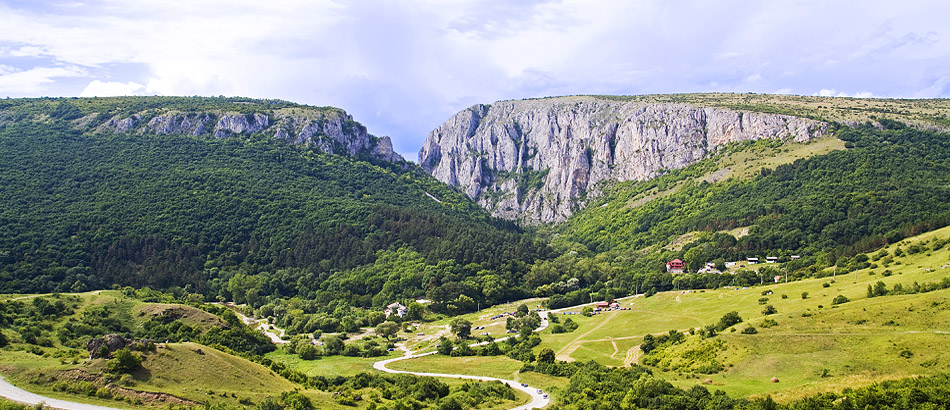
(EN) The Turda gorge was formed in the Rimetea allochton during the Mesozoic, on volcanic and sedimentary origin rocks. On the ophiolite rocks in the depths during a sea flooding clung some limestone from the Jurassic. The rocks are less stratified, north-west of the central parts rather sinker structure. On the gorge (the hospice side) can be found porphyrite Triassic Tuff, while on the Peterd side (left side) younger Cretaceous calcareous marl and sandstone can be found. Triassic and Cretaceous formations beyond the younger Tertiary strata can be observed. The result of the Jurassic karst limestone first developed small caves and then extent of them, by joining an extensive cave system was created. These can be parts of the caves in the gorge today. The internal holes while growth they collapsed and created deep valleys, these are merged and created the ancestor of today gorge , which was especially developed and deepened by the Hăşdate River erosion work. The gorge is 2 900 m long and the walls have heights reaching 300 m. The limestone is a soluble, sedimentary rock which is disolved under the action of water, all the processes related to water flow in soluble rocks and the forms of relief which come into being due to the water activity are known as Karst. Given the way in the formation environment, the karst relief is divided in two categories: surface relief (exokarst) and in-depth relief (endokarst). The limestone corrosion resulted in specific forms, of which the lapiaz are the most varied and widely spread. The frost and the thaw widened the crack of the limestone causing stone crumblings and leading to water flowing in and residual material piling up, thus, forming the gravel at the foot of the mountain sides. The deep cracking of the limestone crests by the underground water led to the formation of numerous caves that can be seen on both mountain sides of the gorge, at different heights.
To claim this earthcache please send me via profile e-mail the answer to the following questions:
1) Of which rock is the gorge mainly made up?
2) How large is the area of the Turda Gorge (in hectars)?
3) What is the color of the Jurassic limeston in the gorge?
4) Why the limestone changing its color in the center of gorge?
Uploaded photos with you and/or your GPS in the Gorge are welcome!
(RO) Cheile Turzii s-au format în alohtonul Rimetea în era mezozoică, pe roci cu origine vulcanică și sedimentară. În timpul unei inundații a mării s-au depus calcare din jurasic pe stâncile de rocă eruptivă din adâncimi. Rocile sunt mai puțin stratificate, au direcţia nord-vestică, iar părţile centrale sunt mai degrabă structurate în bloc. În partea dinspre cabană a cheilor poate fi găsit tuf porfirit din triasic, în timp ce pe partea dinspre Petreşti (partea stângă), pot fi găsite marnă calcaroasă din timpul cretacicului şi gresii. Dincolo de formațiunile triasice și cretacice pot fi observate şi straturi terțiare. In calcarul din Jurasic s-au dezvoltat mai întâi peșteri mici, iar apoi aceste peșteri s-au mărit și s-au unit într-un sistem extins. Peșterile de azi din chei pot fi părți ale acestui sistem. Cavităţile interioare au crescut, iar apoi s-au prăbușit, creând astfel doline, care s-au unit și au devenit strămoșul cheilor de azi. Acestea s-au dezvoltat și adâncit sub eroziunea Râului Hășdate. Cheile au o lungime de 2 900 m, iar pereții au înălțimi ajungând la 300 m. Calcarul este o rocă sedimentară, solubilă, care se dizolvă sub acțiunea apei. Totalitatea proceselor legate de circulația apei în roci solubile și formele de relief care iau naștere în urmă acțiunii apei, conturează noțiunea de CARST. Relieful carstic este împărțit în două categorii: relief de suprafață (exocarst) și relief de adâncime (endocarst). Coroziunea calcarelor a generat forme specifice, dintre care lapiezurile sunt cele mai variate și răspândite. Îngheț-dezghețurile au lărgit fisurile calcarelor, deschizând noi căi de pătrundere a apelor sau producând surpări și aglomerați de materiale reziduale ce constituie trenele de grohotișuri de la baza abrupturilor. Fierăstruirea adăncă a culmii calcaroase de către apele pătrunse pe căile subterane a dus la formarea de grote și peșteri, care apar pe ambii versanți ai cheilor, la altitudini diferite.
Pentru a loga acest earthcache vă rog să-mi trimiteți prin e-mail răspunsurile la următoarele întrebări:
1) Din ce rocă sunt alcătuite în principal cheile?
2) Cât de mare este zona Cheile Turzii? (în hectare)
3) Care este culoarea calcarului jurasic din chei?
4) De ce calcarul își schimbă culoarea în centrul Cheilor?
Fotografii încărcate cu tine și / sau GPSul în Cheile Turzii sunt binevenite!
Additional Hints
(No hints available.)
Treasures
You'll collect a digital Treasure from one of these collections when you find and log this geocache:

Loading Treasures