The posted coordinates will take you to Homer Watson Park and a lookout of the valley below where you will observe a river meander. You will then apply your knowledge of two fluvial forms to understand the benefits they have had on the local golf industry. The City of Kitchener has asked that everyone at the lookout to stay behind the fence for your safety.
The Classroom
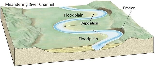
First a summary of terms you will need for your tasks. This Earthcache will reference 2 fluvial terms; Meander and Floodplain. As a river flows, the water constantly works at eroding the edges of its banks. At some point in most rivers, there are curves or bends in the stream channel called Meanders. The river erodes material along its outer banks and deposits it elsewhere where lower water velocity allows it. The erosion of the river's banks begins the work of carving a Floodplain, which is a flat level area surrounding the river channel and often located on the inside of a river meander.
Meander
A meander is a bend in a watercourse or river. A meander forms when moving water in a watercourse erodes the outer banks and widens its valley, and the inner part of the river has less energy and deposits silt. A stream of any size may assume a meandering course, alternately eroding sediments from the outside of a bend and depositing them on the inside. This deposition on the inside the meander creates a low lying area resulting in a floodplain (see diagram).
Floodplain
A floodplain is an area of land adjacent to a stream or river that stretches from the banks of its channel to the base of the enclosing valley walls and experiences flooding during periods of high discharge (see diagram). Floodplains are often made by a river meander eroding sideways as it travels downstream. When a river breaks its banks and floods, it leaves behind layers of alluvium (silt). These gradually build up to create the floor of the flood plain. The alluvium coarseness and composition depends on the surrounding landscape and the velocity of the currents that created the flood plain. These are accumulations of sand, gravel, loam, silt, and/or clay, and are often important aquifers adding water back into the watertable.
People and Floodplains
Floods are usually seasonal and can be predicted ahead of time. This predictability can make flood plains ideal locations to develop urban areas. Rivers provide a source of water for irrigation, potable drinking water, and industry. However, with habitation comes risks. Managing development of flood plains is a critical responsibility for regional and urban planners. The benefits of flood plains, including recreation, agricultural land and desirable housing locations, must be balanced with the personal and economic threats posed by floods. Because of this there are strict rules for the construction of buildings in a flood plain.
The Grand River Conservation Authority (GRCA) has such a plan named GRCA Policies for the Administration of Ontario Regulation 150/06. It regulates everything in relation to development adjacent to watercourses. Within the policy there are specific provisions for golf courses. Section: 8.1.19 states:
Golf Courses or Golf Course Expansions may be permitted in accordance with the policies in Sections 7.1.2-7.1.3 - General Policies, and where it can be demonstrated that:
- all associated permanent, closed structures including clubhouses, washrooms with septic systems and maintenance buildings are located outside of the Riverine Flooding Hazard,
- all greens and tees are located above the elevation of the 1:10 year flood event,
- there is no loss of flood storage
- watercourse crossings are minimized
- the risk of property damage is minimized through site and facility design and flood emergency plans, and
- the risk of pollution from the application of fertilizers, herbicides, pesticides or insecticides or other chemical or organic compounds is minimized and addressed in a turf management plan.
Tasks
To complete this Earthcache visit the posted coordinates and observe the golf course below and answer some questions about it. You will also need to virtually visit the EC's posted reference points on a satellite or regular map service to answer the final questions. I would suggest satellite view to get a better view. One or two sentences is fine when answering. I'm not expecting PhD thesis type answers.
Questions
1. From the posted coordinates look over the golf course. What type of topography do you see; low lying plain or tall hills and ridges like you are currently standing on?
2. Do you think this golf course is built on a flood plain? Use what was learned about river meanders and the type of topography you observe.
3. Can you see any permanent structures built on the golf course? Can you explain why or why not?
4. During flooding, is this golf course important to water recharge? Why or why not
5. Using a map service, I suggest a satellite view to see the golf courses better, view the reference points of 6 golf courses I provided in the cache page below. Each of these golf courses have something in common in relation to their locations along the Grand river. Are they located on the inside of a meander or an outside of a meander?
6. In one short sentence explain why a floodplain is a good location for a golf course?
7. (Optional) Add a photo of you or your view from this beautiful lookout. The Fall is a great time to visit.
Sources:
| Diagram |
https://www.asu.edu/courses/gph111/Fluvial/FluvialOutline.html |
| Flood Plains |
http://nationalgeographic.org/encyclopedia/flood-plain/ |
| Meanders |
https://en.wikipedia.org/wiki/Meander |