

LestISmiteThee's TB Tattoo Geo-miles:
Traveling the world, one Geocache at a time...

The Camel's Den is the only known cave in Howard County. It's located in Daniel's Area of Patapsco Valley State Park just 20 feet (6.1 meters) from the Patapsco River. It stands at an elevation of 240 feet (73 meters) and measures 8 feet (2.4 meters) high, 6 feet (1.8 meters) wide, and 15 feet (4.6 meters) deep. As you'll see, this cave is pretty little, so no spelunking is required to find this EarthCache!
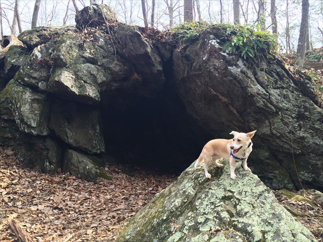
Camel's Den was formed from Cockeysville Marble, which is highly crystallized white metalimestone laced with calc-schist and a variety of other minerals. This type of rock was most famously used in the Washington Monument, but you will notice the cave here isn't white. It was formed during the Cambrian to Ordovician geologic time periods and has been undergoing at least 130 million years of weathering and erosion. The present landscape of hills, valleys, and streams was formed due to weathering during the last 10 to 15 millions years. Minerals found within the marble and calc-schist include phlogopite, a brownish mica that can make the stone appear slightly grey, and quartz, so you may see bits of quartz in the area.
The origins of this cave's name is unknown, but an historical reference speculates that early settlers thought the arched entrance resembled the outline of a camel. It was used as a temporary shelter by Native Americans prior to the arrival of settlers. Note the natural "chimney" at the back of the cave which would have allowed campfire smoke to escape through the small hole in the hill above the cave.
In the 1920s and 1930s, local trapper William Bridner discovered numerous Native American artifacts, indicating that the cave was used centuries before settlers arrived. Later, archeologists such as Samuel Evans and Martin H. Muma conducted research of the region's artifacts. The last known written account regarding the artifacts appeared in the April 1946 issue of the Maryland Journal of Natural History where Muma reported that "two separate digs were made at Camel's Den, and large numbers of artifacts were uncovered and removed."

Please observe park hours of sunrise to sunset. Bicycles and leashed dogs are allowed. You can also enjoy fishing above and below the dam. Use the listed waypoints for parking and trail directions. For more info about Daniel's Area and Cockeysville Marble, please check out the caches CAM 2014 - Patapsco Valley - Daniels Area and Cockeysville Marble.
There is no physical cache container at this location. To officially log this Earthcache, you must send us a message within one week of logging it with the correct answers to the following questions. No guessing required -- all questions can be answered on-site with location observation and info provided in the cache description. Logs containing answers or logs without a corresponding message sent to us within one week will be deleted with or without warning.
1) What is the predominant color of the cave and what two reasons can you think of as to why the rocks are this color instead of white?
2) List three other colors and two patterns you observed in the rocks.
3) What do you think the shiny specks in the rocks are?
4) Ten steps down from the top of the cave, what does the sign on the left tree say?
Optional: Take photos of the cave!
Sources:
The Baltimore Sun
Maryland Geological Survey site
Maryland Geological Survey's Caves of Maryland
Delaware Geological Survey
Museum of Fine Arts Boston
Quadrangle Atlas No. 3
Geological Society of America
Congrats to wizardofmd69, GnomeGCer, Biblical, and Dixiegurl Suzanne for co-FTF!