Sur les "earthcaches", il n'y a ni boîte, ni logbook. Pour valider votre Earthcache il vous suffit de vous rendre sur place et de répondre aux questions posées. Vous pouvez loguer en "Found it" sans attendre mais vous devez me faire parvenir vos réponses en même temps en me contactant soit par mail dans mon profil, soit via la messagerie geocaching.com (Message Center), et je vous contacterai en cas de problème. Les logs enregistrés sans réponses seront supprimés.
On " Earthcaches ", es gibt keine Box, kein Logbook. Um Ihr Earthcache zu validieren müssen Sie nur rausgehen und die Fragen beantworten. Sie können "Found it" loguen ohne Warten , aber Sie müssen mir Ihre Antworten zur gleichen Zeit senden , Sie können mich kontaktieren entweder per E-Mail in meinem Profil oder über geocaching.com Messaging ( Message Center), und ich werde Ihnen bei Problemen kontaktieren. Log ohne antworten werden gelöscht.
On " Earthcaches " , there is no box , no logbook . To validate your Earthcache you just have to go out there and answer the questions . You can log "Found it" without waiting but you must send me your answers at the same time by contacting me either by email in my profile or via geocaching.com messaging (Message Center ), and I will contact you in case of problems. Registered logs without answered will be deleted.
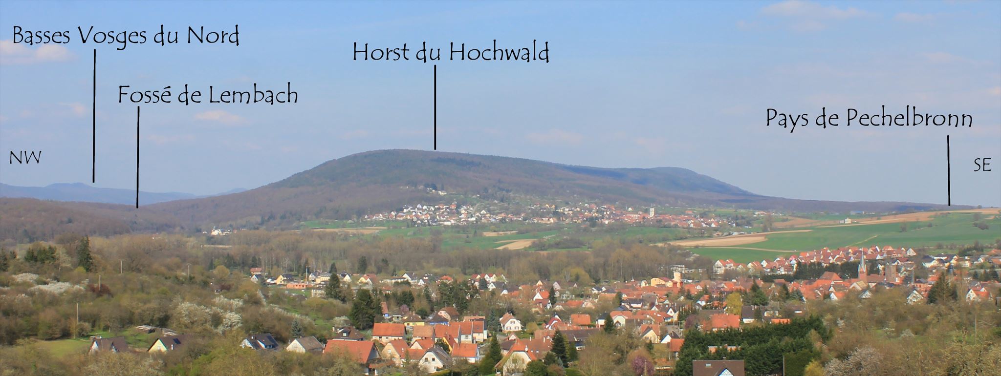
Le Horst du Hochwald
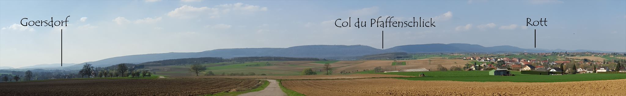
Point de vue de Soultz-sous-Forêt
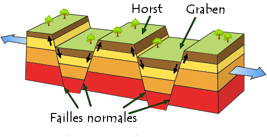
Rappel sur la formation d'un Horst :
Le horst (mot allemand signifiant nid d'aigle ) résulte d'une extension de la croûte terrestre : le bloc soulevé appartient à la portion de croûte terrestre qui est restée stationnaire ou s'est soulevée tandis que, de chaque côté, les compartiments voisins s'abaissaient et forment des Graben (mot allemand signifiant fossé ).
Erinnerung an bestimmte die Bildung eines Horst:
Ein tektonischer Horst ist eine Scholle (daher auch Horstscholle), die zwischen annähernd parallelen Verwerfungen relativ zu den benachbarten Schollen herausgehoben wurde. Das Gegenstück zu Horst ist ein Graben.
Reminder about the formation of a Horst:
In geology, horst and graben refer to regions that lie between normal faults and are either higher or lower than the area beyond the faults. A horst represents a block pushed upward by the faulting, and a graben is a block that has dropped due to the faulting. Horst and Graben are formed when normal fault of opposite dip occur in pair with parallel strike lines . Horst and Graben are always formed together. Graben are usually represented by low-lying areas such as rifts and river valleys whereas horsts represent the ridges standing between/on either side of these valleys.
Le soulèvement d'un horst comme l'abaissement d'un graben peut entraîner la formation de pièges structuraux : cela signifie que les hydrocarbures se sont retrouvés piégés par le déplacement de couches imperméables (comme l'argile) le long d'une faille.
Der Aufstand eines horst wie das Absenkung eines Graben kann die Bildung von strukturellen Fallen verursachen: das bedeutet dass Kohlenwasserstoffe durch Bewegen undurchlässige Schichten (wie Ton) entlang eines Fehlers gefangen geworden sind.
The uprising of a horst like the lowering of a graben can cause the formation of structural traps: this means that hydrocarbons have become trapped by moving impermeable layers (such as clay) along a fault.
La formation de la plaine d'Alsace
Il y a 65 millions d'années, les Vosges et la Forêt-Noire ne formaient qu'un seul massif s'élevant jusqu'à trois mille mètres. À la suite de la formation des Alpes, deux lignes de cassures parallèles se formèrent dans le massif. La zone comprise entre ces deux fractures s'effondra progressivement et fut envahie par la mer, la comblant en partie de dépôts marins. Plus tard, le Rhin s'insinua dans ce fossé, y apportant des alluvions et entraînant la formation du bassin potassique et de plusieurs bassins houillers. On trouve en Alsace 4 champs de fracture, celui qui nous intéresse est le plus vaste c'est celui de Saverne avec 80 kilomètres de long et 20 kilomètres de large.
Die Bildung der Elsässischen Ebene
Vor 65 Millionen Jahren waren die Vogesen und Schwarzwald eine Masse von bis zu dreitausend Meter. Nach der Bildung der Alpen, wurden zwei Linien parallel Risse in den Bergen gebildet. Der Bereich zwischen diesen beiden Brüche brochen allmählich zusammen und wurde durch das Meer uberschwemmt und von Meeresablagerungen gefüllt. Später wurde der Rhein sanft in diesen Graben trat, er brachte Schwemmland und führte die Bildung des Kali-Becken und mehrere Kohlen-Becken. Wir finden in Elsass 4 Fraktur Felder, der wie uns interessiert ist die größte, es ist der von Saverne mit 80 Kilometer lang und 20 Kilometer breit.
The formation of the plain of Alsace
There are 65 million years, the Vosges and the Schwarzwald were one mass of up to three thousand meters. Following the formation of the Alps, two parallel cracks were formed in the mountains. The area between these two fractures gradually collapsed and was invaded by the sea, filling in part of marine deposits. Later, the Rhine entered gently into that ditch, he brought alluvium and led the formation of the potash basin and several coal basins. We found in Alsace 4 fracture fields, the one that interests us is the largest one it is that of Saverne with 80 kilometers long and 20 kilometers wide.
Le Hochwald
Les réseaux de failles de la petite région naturelle de l'Outre-Forêt permettent de distinguer d'Ouest en Est 4 grandes unités:
- Le Horst vosgien (bord sud du plateau lorrain)
- La faille vosgienne, étroit réseaux de failles constituants plusieurs paliers d'effondrement au pied des Vosges
- Le champs de fracture de Saverne (partie nord est), en partie surélevé : Horst du Hochwald
- Le fossé Rhénan, à l'Est
Die Bruchsystemen des kleinen natürlichen Region "l'Outre-Forêt" kann von West nach Ost in 4 großen Einheiten unterscheidet werden:
- Der Vogesen Horst (Südrand der Hochebene von Lothringen)
- Die Vogesen Spalte, enge Spalte System welcher mehrere zusammengebrochene Ebenen am Fuße der Vogesen bildet
- Die Bruchfelder von Saverne (nördlicher Teil), teilweise erhöht: Horst Hochwald
- Der Rheingraben, im Osten
The fault system of the small natural region of the "Outre Forêt" allow us to distinguish from West to East 4 major units:
- Horst Vosges (south edge of the plateau of Lorraine)
- The Vosges fault, tight fault system constituents several levels of collapse by the Vosges
- The fracture fields of Saverne (northern part), partly raised : Horst Hochwald
- The Rhine ditch, at East
Point de vue de Woerth
Photo prise depuis la Tour mémorial d’Elsasshausen
Le horst du Hochwald est un élément fort et très visible du paysage de l'Outre-Forêt se dressant en avant des Vosges. L'important massif vosgien est constitué par les grès vosgiens qui affleurent le long de la faille vosgienne et reposent sur les grès d'Annweiler. A l'Est de la faille vosgienne s'étend le fossé de Lembach où affleurent essentiellement les formations du Muschelkalk.
Le Horst du Hochwald constitue un massif gréseux triasique atteignant des altitudes de plus de 500m. Le point le plus haut atteint 514m d'altitude, mais il se situe sur un terrain militaire d’accès interdit. Il est délimité par deux failles majeures, quasi symétriques par rapport à son axe : au Sud Est la Faille Rhénane et au Nord Ouest le fossé tectonique de Lembach qui correspond à la terminaison en coin du champ de fractures de Saverne.
Die horst Hochwald ist eine starke und sehr sichtbare Teil der Landschaft des Outre-Forêt der vor den Vogesen steht. Die wichtige Vogesen Gebirgsmassiv besteht aus dem Vogesen-Sandstein der zu Tage tretenden entlang der Vogesen Spalte und sind auf dem Sandstein von Annweiler basiert. Im Osten der Vogesen Spalte erstreckt der Lembacher Graben, wo im Wesentlichen Formationen Muschelkalk zu Tage treten.
Der Hochwald Horst ist eine Trias Sandstein -Massiv der einer Höhe von über 500 m erreicht. Der höchste Punkt erreicht 514 Meter, aber es befindet sich auf einem Militärgelände , wo der Zugang verboten ist. Es wird von zwei großen Spalte begrenzt, fast symmetrisch in Bezug auf seine Achse: am Süd-Ost der rheinischen Spalte und am Nord-West der tektonischen Graben von Lembach die die Beendigung Ecke von Saverne Frakturen Feld ist.
The horst Hochwald is a strong and very visible part of the landscape of the Outre-Forêt standing in front of the Vosges. The important Vosges massif consists of the Vosges sandstone outcropping along the Vosges fault and are based on the sandstone of Annweiler. To the east of the Vosges fault extends Lembach ditch where essentially outcrop formations Muschelkalk.
The Hochwald Horst is a Triassic sandstone massif reaching altitudes of over 500m. The highest point reaches 514 meters, but it is on a military site where access is prohibited. It is bounded by two major faults, almost symmetric with respect to its axis: at the South East the Rhénane Fault and at the North West of the rift Lembach, which is the termination corner of Saverne fractures field.
Pour valider cette Earthcache veuillez répondre aux questions suivantes:
Um diesen Earthcache zu validieren beantworten Sie bitte die folgenden Fragen:
To validate this Earthcache please answer the following questions:
Comment s'est formé le massif sur lequel vous vous trouvez ?
Quelle est l'altitude maximale du Hochwald ?
Quelle est la couleur du Grès dans la carrière dans laquelle vous stationnez ?
Sur la table panoramique citez les noms inscrits dans le cadre réalisation ?

Wie bildeten sich die Berge, auf denen Sie sind ?
Was ist die maximale Höhe von der Hochwald ?
Was ist die Farbe des Sandstein im Steinbruch , wo Sie parken?
Am Orientierungstafel zitieren die Namen die unter "réalisation" registriert sind ?
How was formed the mountains on which you are ?
What is the maximum altitude of Hochwald ?
What is the color of the sandstone in the quarry where you park?
On the viewpoint cite the names listed under "réalisation"?
NB: Sur place veuillez respecter les panneaux indiquant les zones accessibles, le horst du Hochwald est en partie occupé par la base aérienne
NB: Vor Ort bitte den Schildern nach zugänglichen Bereichen folgen, die horst Hochwald wird zum Teil von der Luftwaffenbasis besetzt
NB: On site please follow the signs to accessible areas, the horst Hochwald is partly occupied by the air base