General Background to Dunnet Head
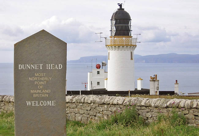
Dunnet Head is a peninsula in Caithness, on the north coast of Scotland. Dunnet Head includes the most northerly point of the mainland of Great Britain. The point itself is known as Easter Head, however the geology is the same throughout Dunnet Head. Although Easter Head is the most northerly point on the Scottish mainland, it is important to note that the northern-most point of Scotland lies in the Shetland islands, approximately 170 miles further north.
The co-ordinates bring you to the most northerly point open to the public. It’s not quite at the tip of the peninsula, as the Dunnet Head Lighthouse actually occupies the very end, and this is private land. The current lighthouse was built in 1831 by Robert Stevenson, the grandfather of famed author Robert Louis Stevenson. The original fog signal was built in 1899 but the rock on which it stood eroded - so it was abandoned and a new one was built nearer the lighthouse. This may tell you something about the rock at Dunnet Head!
To log the earthcache, you need to visit two waypoints - only a short walk is involved from the car park. The first location will give you a view of the cliffs at Dunnet Head, the second takes you to the trigpoint, the highest location on the peninsula, where there is a viewpoint and you can look out to the sea and Orkney Islands.
Dunnet Head has been in the care of the RSPB since 2008 and in February this year (2016) they purchased the land permanently. The cliffs are home to puffins, razorbills, guillemots, fulmars, kittiwakes, shags and cormorants, whilst above the cliffs are some very diverse coastal heathland and grassland habitats with special plants such as spring squill, thrift and roseroot. At present there are also no facilities (still the case 2022) - the site is slowly being improved. I believe there is now a voluntary parking fee, but my understanding is it is not an enforced charge - please check the signs carefully. The RSPB have very kindly supported the publication of this earthcache, please do visit their website for up to date information about Dunnet Head.
Click here for the RSPB website.
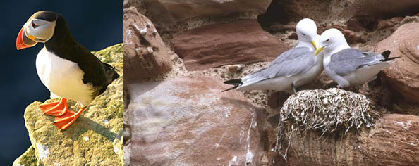
The cliffs at Dunnet Head provide ideal conditions for many birds.
Caithness and Sutherland contain rock formations of outstanding geological interest, which span over 2,800 million years and include some of the oldest surface rocks in Britain. Along the west coast, the oldest rock in the region, Lewisian gneiss, creates a landscape of low hills and scattered lochans. Rising from this gneiss landscape are huge masses of Torridonian sandstone, capped by quartzite, which form the distinctive mountains of Cul Mor, Suilven, Canisp and Quinag.
Great Britain’s Most Southerly Point down at Lizard Head is made up of Man of War Gneiss. This is one of the oldest and hardest rock types in the country, and it’s more northerly equivalent is the Lewisian gneiss mentioned above – however it is not gneiss you will find here – the most Northerly Point is actually made up of Old Red Sandstone.
Background Geology of the Caithness Region
Much of Caithness is underlain by Middle Devonian flagstones - thinly-bedded siltstones and sandstones which cleave to give sheets of rock which have used extensively in the past as paving, tiles and field boundaries. These sedimentary rocks were laid down around 370 million years ago in a huge lake. The sedimentation was rhythmic - driven by similar climatic astronomical cycles which determined the tempo of the Ice Age. As the cycles were repeated again and again, layers of rock were produced with a cumulative thickness of a massive 4 km.
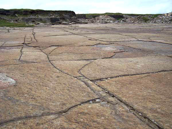
The Middle Devonian flagstones found across much of Caithness.
The sequence found in the Caithness region is:
1. laminite - dark grey organic silt, often with fish remains
2. inter-layered dark shale, siltstone and limestone, with polygonal cracks
3. coarse siltstones with ripple bedding
4. shale, siltstone and fine sandstone, with ripple marks and desiccation cracks.
The sequences represent the response of the lake to changes in rainfall and evaporation by progressive shallowing of the anoxic (oxygen depleted) floor of the lake, with first wave action and disturbance and finally exposure and drying out.
At Dunnet Head the succeeding group of Upper Old Red Sandstone are coarser and tougher rocks, although they have sandstone beds that include a calcareous cement (e.g. it is mostly or partly composed of calcium carbonate), and these sandstone beds weather to in such a way they display distinctive pitted surfaces.
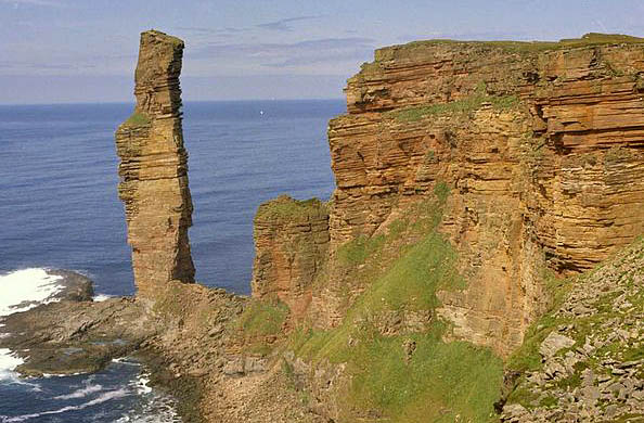
The Old Man of Hoy only a short distance away on Orkney is the most famous of the local Upper Old Red Sandstone landmarks. (Old Man of Hoy earthcache - GC551MK).
The Old Man of Hoy survives because it is perched on a plinth of basalt rock, which is very hard. At Dunnet Head this is not the case, beneath the Upper Old Red Sandstone lies the softer conglomerates and breccias of the Lower Devonian. The Sarclet Conglomerate is a particularly distinctive and attractive stone, with pebbles of granite, schist, quartzite and basalt set with in a red sandstone matrix. These sediments rest on and are largely derived from the Moine metamorphic rocks of east Sutherland and the Caledonian granite intrusions, of which the Helmsdale Granite is the best exposed.
The Geology of Dunnet Head
In simple terms, Dunnet Head in made from what is known as ‘the Upper Old Red Sandstone’.
The Old Red Sandstone describes a suite of sedimentary rocks largely deposited in a variety of environments during the Devonian era. The body of rock, is dominated by loose sediments and conglomerates at its base, and progresses to a combination of sedimentary layers formed from dunes, lakes, and river sediments.
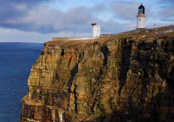
The Upper Old Red Sandstone Cliffs at Dunnet Head.
The familiar red colour of these rocks arises from the presence of iron oxide but not all the Old Red Sandstone is red - or even sandstone - the sequence also includes conglomerates, mudstones, siltstones and thin limestones and colours can range from grey and green through red to purple. These deposits are closely associated with the erosion of the Caledonian Mountain chain which was thrown up by the collision of the former continents of Avalonia,Baltica and Laurentia to form the Old Red Sandstone Continent- an event known as the Caledonian Orogeny.
The rocks you can see at Dunnet Head were deposited in the Upper Devonian era. In simple terms, this means the rocks were formed during the most recent of the three Devonian periods, so the Upper Old Red Sandstone here is some of the newest of it's type you will find, and in simple terms, that means it is harder than similar rock formed in earlier Devonian periods. As you can see from the illustration below, in this area, only Dunnet Head is made from this particular type of rock.
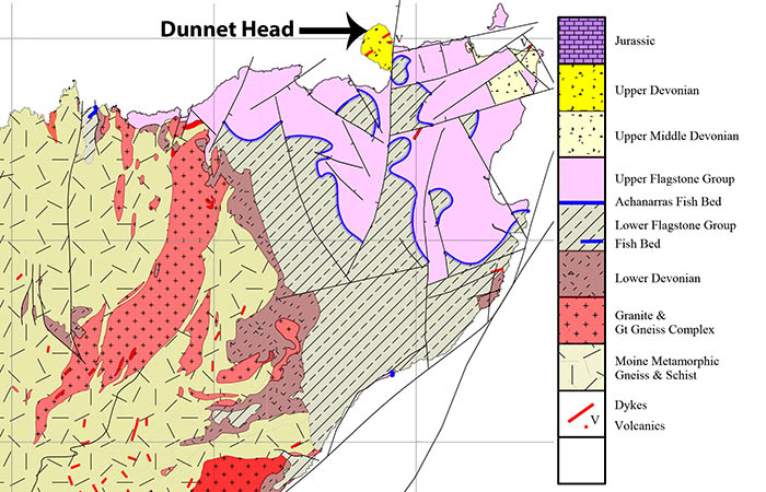
A map showing the geology found in Caithness.
Dunnet Bay
It's worth briefly mentioning the adjacent Dunnet Bay, which is considered a feature of primary importance in the coast of Scotland. The beach at Dunnet Bay is one of the largest in northern Scotland, extending for over 4 km in a broad symmetrical curve, on account of its enclosed nature between the high sandstone cliffs of Dunnet Head to the north, and the low flagstone platform to the south. Since it is so enclosed it acts as an effective sediment trap: the only escape for sand from the bay is landwards. It is therefore not surprising that a wide, high sand dune system and extensive links plain has accumulated landwards of the enclosed bay.
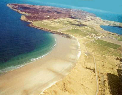
The aerial view shows some of Dunnet Bay with the beach, sand dunes and Dunnet Head behind.
Logging Requirements (Questions to Answer)
Please e-mail me the answers to the below questions via my profile. I do read all answers and try to reply to them all; I may not reply immediately so please do not wait for a reply before posting your find. Ideally, please send your answers at the same time you submit your log, or within a few days of your visit. I do check answers have been sent for every log, if you do not send answers within a week your log may be deleted. You are not expected to have any previous geological knowledge, your best attempt at the answers is all that is required.
First, please visit the given co-ordinates (for Q1 and Q2). This will take you to an easily accessible place where you can view the cliffs.
Q1 – You will see lots of layers of rock that form the cliff. Each layer was formed as a climatic cycle took place - the thin layers mean a shorter cycle than the thick layers. How many cycles approximately did it take to form this cliff (e.g. roughly how many layers are there from the top to the bottom?) Also estimate the height of the thinnest layer and the height of the thickest layer. I know it's hard from this distance, a rough estimation is fine.
Q2 – Look at the rock. It’s a rock type called ‘Old Red Sandstone’ but this doesn't necessarily mean the rock is red, this only occurs if iron oxide is present. It can be yellow, brown, or perhaps another colour, and this may vary in different layers as they were formed over a long period of time. Please tell me approximately what colours you see in percentage form (for example 10% purple, 40% green, 25% red, 25% blue).
Now, please visit waypoint 1 (the viewpoint). The waypoint co-ordinates are for the path near the viewpoint.
Q3 – Please stand in the middle of the circular viewpoint and take an elevation reading. Although you are standing near the trigpoint (which is officially 129m / 423ft), I expect this reading to be slightly different to the official OS measurement. This gives you an idea of the height of these Old Red Sandstone cliffs above sea level. *
Q4 – Consider the geology. The rocks at Great Britain’s Most Southerly Point are Old Man Gneiss, a very hard rock that has been pushed up from deep inside the earth. However, here at the most Northerly Point, we see a sedimentary rock that has formed from the accumulation of sediments and compacted into rock over time. Briefly, explain which end of the Great British mainland is likely to be eroding more quickly, and why?
Q5 - Take a look to the north from here (out to sea). If it's misty, take a look what lies to the north on a map. What do you see? Has Dunnet Head always been the most Northerly Point of the mainland do you think? Does what you see have any impact on erosion at Dunnet Head?
And finally, continue to Waypoint 2, which is very near the car park. Here you will find a stone erected to mark the fact that you are at the most Northerly point of the Great British mainline.
Q6 (optional) - Please include a photograph of yourself or your GPSr with the stone, many people still like this evidence of their visit and it is a unique opportunity to be photographed at Great Britain's Most Northerly Point.
* Many people are messaging me saying they can't provide an altitude and this is not really acceptable. It is a basic GPS function, receivers can determine altitude by trilateration with four or more satellites and any device including a mobile phone can do it - but you may need to install the relevant application in advance. Given I have provided you with the height of the trigpoint, if you have visited the locations you should be able to at least offer an estimation and I would rather you did that than skip the question.
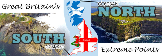
Great Britain's Extreme Points Badge
There is now a profile badge available if you have successfully logged both this earthcache and the sister earthcache at Lizard Point.
Copy and paste the below code into your profile if you wish to display the badge.
<a href="http://coord.info/GC5KK3T"><img src="https://s3.amazonaws.com/gs-geo-images/8c08a40e-dd6c-446f-bf3d-4bd9bd532364.jpg" /></a>
Please enjoy your visit to Dunnet Head.