Where does water energy come from?
The water cycle is one of most basic processes that goes on around us in nature. Water falls from the sky in the form of rain, snow or hail, and this process is called precipitation. In this area, that precipitation falls onto the hills and countryside you can see around you. It percolates through the soil and rocks, with gravity forcing it downwards to form a stream. This then travels downhill joining other streams. The point at which all these tributaries join the river is called a confluence.
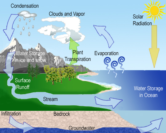
The Water Cycle
These processes have now formed the river you see before you. This river continues downwards being joined by more and more tributaries where eventually, it will join oceans and lakes. The water then evaporates into the sky again and the cycle continues.
So we join the water perhaps halfway through the water cycle described above. We are still about 80 metres above sea level here but more importantly, the highest point of Marple is Cobden Edge, which sits at 327 metres above sea level. So just within the local area, the water falls around 250 metres before it reaches the weir here, and of course there are even higher hills not far away. That drop in height gives the river here some current and force by the time it passes this weir. The water level and the speed/power of the water may vary depending on the amount of rain in the preceding days before you visit as we are relatively near the hills here, which means the river is quickly affected by precipitation.
Harnessing the power of this water
The weir you see here was built by Jesse Howard of Stockport around 150 years ago. He planned to build a cotton mill - old weirs such as this often show the site of mills that in years gone by, also intended to take advantage of the energy available in the local rivers to power their machinery. On this occasion, the mill was never built.
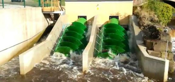
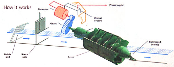
The Archimedean screws at Stockport Hydro
Following the successful completion of the Torrs Hydro further upstream at New Mills in 2008 (the UK’s first ever community owned hydro scheme), planning for this Otterspool scheme began soon after in 2009. By October 2012 power was being generated and by March 2013 100,000 units (kWh) of electricity had been generated.
The system works by diverting water from the weir and using the water to turn the two huge Archimedean screws you can see in front of you here (named Thunder and Lightning). These can each generate 60kW of electricity when the water is flowing most quickly. At this time 260 tonnes of water flow down the screw every minute, but this can drop to as little as a tenth of that figure when the water is low in dry periods of weather. On average, the power produced by this hydro generator provides green energy for around 175 local residents (60 homes) each year. Usually on schemes such as this, there are periods when the screws do not turn, however, here at Stockport they have found that even in the driest periods, they have been able to generate power.
Considerations to the local wildlife must be made. The design ensures that any fish passing down the screw would not be harmed, and a special fish pass has been installed to ensure fish such as salmon can get back up the river to breed. It is important that there is always at least 6cm depth of water flowing over the weir to protect the wildlife and ecosystem of the river, and so the system will always ensure these levels are maintained.
Otterspool Bridge
It would be impossible to stand and admire the hydro power system and weir without taking note of the Grade II listed bridge which stands as the backdrop to the view. It spans over the River Goyt using three segmental arches, standing on weathered triangular cutwaters. The arches separated by square pilasters. A pilaster is an architectural element in classical architecture used to give the appearance of a supporting column and to articulate an extent of wall, with only an ornamental function. The bridge was built in the early 19th century, and then widened in the 20th century using the same materials. You will notice that the bridge has been strengthened with the use of concrete arches.
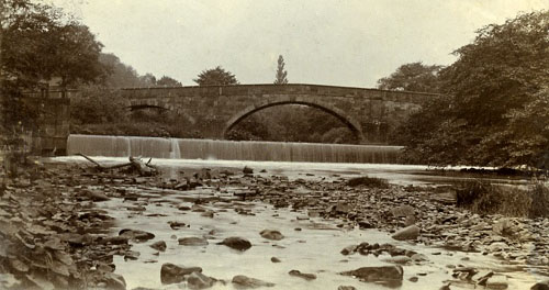
A historic view of Otterspool Bridge, before the hydro, and before it was widened.
Logging Requirements (Questions to Answer)
Firstly, please include question 1 and 2 in your online log.
1 – Please take a look at the amount of water flowing over the weir, and consider the amount of rain that has fallen on the days before your visit. Estimate in your online log as a percentage, how much power you think might be currently being generated today - 100% being the maximum possible, and 0% signifying the screws are not currently turning. I appreciate this will only be a rough approximation, but bear in mind, when working at maximum power, the screws turn at roughly 25 revolutions per minute, with around 5 cubic metres of water per second passing down each screw.
2 – (optional) - Please, if you wish, include a photograph of yourself or your GPSr with the Archimedes screws in the background - many people still like this evidence of their visit.
Please send the answers to the remaining questions to me as a message via my profile. I do read all answers and try to reply to them all; I may not reply immediately so please do not wait for a reply before posting your find. Ideally, please send your answers at the same time you submit your log, or within a few days of your visit. I do check answers have been sent for every log, if you do not send answers within a week your log may be deleted. You are not expected to have any previous geological knowledge, your best attempt at the answers is all that is required.
3 – Take a look at the River Goyt at this location. There are many places along the river where this hydro station could have been built. Why do you think this location was chosen?
Now turn your attention to Otterspool Bridge.
4 – Please examine the stones the bridge is made from. You can walk right up to them, please take care near the edge. From the three below options below, which do you believe is the stone used to build the bridge?
- Limestone. A sedimentary rock, often composed of skeletal fragments of marine organisms such as coral, forams and molluscs. Partially soluble in acidic water. Usually smooth to the touch when used for building. Colour - variable, but generally light coloured, locally in this area it is usually tones of grey. Available relatively locally but would need transporting some distance.
- Red sandstone. A sedimentary rock, composed mainly of sand-sized minerals or rock grains. Allows the percolation of water and other fluids. A popular building material since ancient times, as it is relatively soft, making it easy to carve, and often fairly resistant to weathering. Available very locally. The grains are clearly visible and you can feel a sandy texture when touched.
- Granite. A light-colored igneous rock with grains large enough to be visible with the unaided eye. It forms from the slow crystallization of magma below Earth’s surface. It is hard enough to resist most abrasion, strong enough to bear significant weight, inert enough to resist weathering and it accepts a brilliant polish which would be likely to be visible if used in building work. Not available locally and would need transporting a great distance at great cost.
I have only given a very brief description of the stone types. If you are still unsure, please research on the internet for photos and further information.
5 – The stone on the parapet (top) of the bridge is a different colour from the stone seen on bottom (arches), yet all the stone is the same type. Why is the bottom different to the top?
Please enjoy your visit to Stockport Hydro.