河岸段丘とは?/What is river terrace?
[JP]
河岸段丘(かがんだんきゅう)とは、河川の中・下流域に流路に沿って発達する階段状の地形で、河成段丘(かせいだんきゅう)とも呼ばれます。平坦な部分と傾斜が急な崖とが交互に現れ、平坦な部分を段丘面(だんきゅうめん)、急崖部分を段丘崖(だんきゅうがい)と呼びます(Wikipedia)。
[EN]
River terrace is a land form developed along a river stream in middle or lower reach. Flat areas and steep cliffs appear alternatively. Such flat areas are called ”terrace plain” and such steep cliffs are called "terrace cliff". (Wikipedia (JP))
[JP]
地殻変動や、侵食基準面の変動がその形成原因となります。侵食力を失った河川が隆起や海面低下などにより再び下刻を行うと、それまでの谷底平野内に狭い川谷が形成されます。谷底平野は階段状の地形として取り残され、河岸段丘が一段形成されます。侵食が進んで河床勾配が侵食基準面に近付き侵食力が弱まると、段丘崖の下に新たな谷底平野が形成されます。その後隆起などにより再び侵食力が強くなると新たな段丘崖が形成され、河岸段丘が多段になります
[EN]
Land deformation and change in base level of erosion form river terraces. Even once a river loses its erosion action, the river can start again down cutting due to land upthrust and/or lowering of sea surface, whereby a narrow river valley is formed within the old valley plain. The valley plain is left as a step-wise landform, and thus a river terrace is formed. When erosion proceeds, the river slope comes close to the base level of erosion, whereby erosion action becomes weak, a new river valley is formed under the terrace cliff. Thereafter, when erosion action becomes strong again by land upthrust etc., a new terrace cliff is formed, whereby multi steps of river terraces are formed.
沼田河岸段丘/Numata river terrace
[JP]
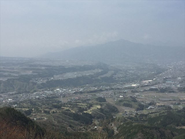
沼田付近では、日本有数の河岸段丘を見ることができます(下写真はAdditional Waypoint"stage 3"から撮影)。
[EN]
In Numata city, you can observe prominent river terraces as shown in the picture below, which picture was taken from Additional Waypoint "stage 3".
[JP]
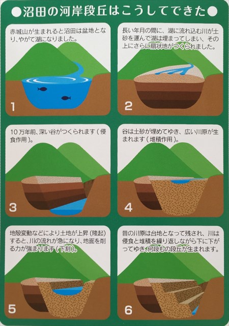
沼田の河岸段丘は下図(パンフレット「日本一有名が河岸段丘の街」より引用)のように形成されたと考えられています。
[EN]
The river terraces in Numata are formed as explained in the figure below.
1. After Mt. Akagi was formed, Numata became a basin and a lake with time.
2. During long years, the river flowing into the lake carried soils, which soils filled the lake.
3. About 100 thousand years ago, the river formed a deep valley with its erosion action.
4. Soils carried by the river filled the valley and formed a wide valley plain (deposition action).
5. When the land upthrusted by land deformation etc., the river stream became steep, and its erosion action became strond (down cutting).
6. The steps 1-5 repeated and the multi steps of river terraces were formed.
河川の侵食・堆積作用/Erosion and deposition by river
[JP]
河岸段丘は、河川の侵食(地表面を削る作用)、運搬(削った砂、礫、泥を運ぶ作用)及び堆積(運んだ砂などを堆積させる)作用により形成されます。湾曲した河川では、曲がりの外側の方が内側よりも水の流れが速く、外側の岸がより多く侵食され、内側の岸により多くの砂などが堆積されます。
[EN]
River terraces are formed with erosion action (eroding a land surface), transport action (transporting eroded soils) and deposition action (depositing transported soils). In a curved river, water flows faster at its external side than at its internal side, thus the bank on the external side is more eroded and more soils are deposited on the internal side.
Task 1
[JP]
このEarthcacheをFoundするためには、以下のクイズの答えをキャッシュオーナに送ってください。
[EN]
For claiming your found, send to the cache owner your answers for the quizzes below.
Quiz 1
[JP]
Additional Waypoint "stage 1"と"stage 2"との間の高度差はおよそ何mですか?"stage 1"は沼田駅前で、河岸段丘の最下面付近です。"stage 2"は沼田市街が発展した段丘面上です。
[EN]
What is the difference in altitude between the Additional Waypoints "stage 1" and "stage 2". Stage 1 is in from of Numata station at the lowest level of the river terraces. Stage 2 is on the terrace plain on which Numata city has developed.
Quiz 2
[JP]
Additional Waypoint "stage 3"の雨乞山山頂から南西方向に河岸段丘を眺望し、片品川の左岸の段丘面と右岸の段丘面とを比べると、どちらの岸の段丘面が広いでしょうか? 何故そちらの岸の段丘面が広いのでしょうか?片品川がどのように流れているのかを考慮して答えてください。
[EN]
Observe the river terraces from the summit of Mt. Amagoi at Additional Waypoint "stage 3" in South-West direction and compare the terrace plains on the right and left banks of Katashina river. Which of right and left banks has wider terrace plains? Why does that bank have wider terrace plain? Please answer by taking into account how Katashina river which has formed the river terraces flows.
Task 2 (Optional)
[JP]
(Optional) Additional Waypoint "stage 3"から撮影した河岸段丘の写真をログと共にアップロードしてください。
[EN]
(Optional) Please upload a picture of the river terrace which you took at Additional Waypoint "stage 3".