Arkansas provides many great opportunities to explore nature, as the "Natural State" you will not want to forget your camera, a walking stick, and a buddy or two to go out and enjoy nature.
In this Earth Cache lesson we are going to continue to learn about erosion.
If you have been working on the Earth Caches on these trails you may have learned what erosion is and the different forms of erosion. On this Earth Cache Adventure we are going to learn about the effects of erosion and what it leaves behind.
After completing this Earth Cache you will have a better understanding of:
- what sediment is
- what the 3 main types of transportation for sediments is
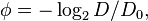
- What phi Scale is
- How to classify grains using the phi scale
- transportation and scale rating at ground zero
- the three types of sediment at ground zero
Sediment
So what is sediment really? Sediment is a naturally occurring material that is broken down by processes of weathering and erosion, and is subsequently transported by the action of wind, water, or ice, and/or by the force of gravity acting on the particles. For example, silt falls out of suspension via sedimentation and forms soil (some of which may eventually become sedimentary rock).
Sediments are most often transported by water (fluvial processes), wind (aeolian processes) and glaciers. Beach sands and river channel deposits are examples of fluvial transport and deposition, though sediment also often settles out of slow-moving or standing water in lakes and oceans. Desert sand dunes and loess are examples of aeolian transport and deposition. Glacial moraine deposits and till are ice-transported sediments.
Krumbein phi scale
Size ranges define limits of classes that are given names in the Wentworth scale (or Udden–Wentworth scale) used in the United States. The Krumbein phi (φ) scale, a modification of the Wentworth scale created by W. C. Krumbein[1]in 1937, is a logarithmic scale computed by the equation
where
 is the Krumbein phi scale,
 is the diameter of the particle, and
 is a reference diameter, equal to 1 mm (to make the equation dimensionally consistent).
This equation can be rearranged to find diameter using φ:

We wont be using this formula today to measure individual sediment, we will just rely on the graphic but its important to know in some schemes, gravel is anything larger than sand (comprising granule, pebble, cobble, and boulder in the table above).
Stream Sedimentation
In the context of stream hydrology, sediment is inorganic and organic material that is transported by, suspended in, or deposited by streams. Sediment load, which is the quantity of sediment transported by a stream, is a function of stream discharge, soil and land-cover features, weather conditions, land-use activities, and many other factors. Sediment load carried by streams and rivers can be composed either of fine materials, mostly silts and clays, or larger materials such as sand.
The sediment, itself, is transported as three distinct loads:
- Dissolved load: The fraction in solution as ions.
- Suspended load: That fine portion that is kept in constant suspension by electrostatic and viscous interactions with the surrounding water. Generally clay or silt sized particles.
- Bed load: That portion that cannot be kept in constant suspension. Generally sand sized and larger. The bed load moves in two manners:
- Saltation: bouncing along the stream bed, or being repeatedly picked up and put down by Flow.
- Traction: The remainder that rolls or slides in constant contact with the bed.

There is a relationship between a stream's velocity (energy) and the size clast that it can transport. Intuitively we sense that larger clasts need more energy to be moved than smaller ones, but reality is more subtle. This is shown in the Hjulstrom diagram (Below), that gives a zone of sediment transport in black. The upper limit is the velocity at which a clast of a given size is entrained, the lower limit is the velocity at which an entrained clast is deposited.
- No surprise that the smallest grains are deposited at the lowest flow velocities.
- But why are sand sized particles entrained before clay particles? (See if you can figure it out.)

Did you Know?
There are about 87,617 miles of streams and rivers in and around the state of Arkansas. The combine flow of the streams within the state averages about 40 billion gallons a day with an additional 30 billion gallons a day brought in to the state from surrounding states in the Arkansas, White, Red and ST. Francis rivers this compares to the daily average of 210 billion gallons a day that flows in the Mississippi River past Memphis. The quality of surface water varies across the state that is mainly due to the fact that eastern and southern Arkansas has what is called “soft” rock exposed at the surface that easily erodes causing the water to be cloudy or turbid when compared to streams in western and northern parts of the state that are underlain by “hard” or consolidated rock.
Requirements: (please do not put your answers in the log)
Now that we learned a little bit about erosion and the effects it has on limestone, take a moment to study ground zero. With the information above, and information at GZ you should be able to answer the following questions. You have 24 hours to send me an email (found in my geocaching profile) with the correct answers. Failure to do so will result in the removal of your "Found it log". Please add the GC code and title in the subject line. If you are sending answers for multiple people in your group, please add all the names in your email to ensure they don't have their log deleted :) Photos with you/group of the area would be greatly appreciated.
1 In your own words define sediment.
2 What are the 3 main types of transportation for sediments?
3 What is a phi Scale?
4 Using the phi scale classify three types of sediment at ground zero. Which is the most prevalent?
5 Looking at ground zero based on what you have learned name the loads of erosion that you can witness here.
Sources used:
Did you know fact
Loads and Charts
Water Sciences
phi scale and equations