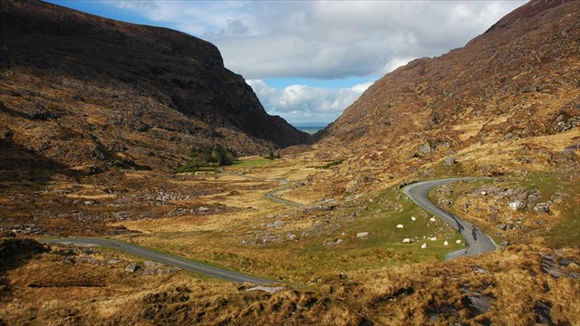
The Gap of Dunloe
The Gap of Dunloe, hewn two million years ago by giant, slow moving ice is probably the finest example of a glaciated valley in western Europe.It is a narrow pass in the the mountains of the McGuillycuddy Reeks mainly between the Purple Mountain on the left and the Bull Mountain. Here the visitor travels along 10kms of winding pathway alongside 5 "Loughs"
Glacial Breach
A glacially eroded trough that cuts through a ridge and so breaches a former watershed. It is formed when the outflow of a glacier (or ice sheet) is impeded, its thickness consequently increases, and ultimately a new escape route (the breach) is exploited. This process is called ‘glacial diffluence’ when a single glacier spills out of its valley, and ‘glacial transfluence’ when several breaches are formed due to the accumulation of a large ice sheet. The many breaches through the western Highlands of Scotland are due to the accumulation of transfluent ice east of the main watershed.
Glaciation here
During the most recent glaciation, from 120,000 to 15,000 years ago, the ice moved north from an ice cap near Kenmare before coming up against the barrier of the McGillycuddy's Reeks. This ice flowed around the Reeks to the east near Killarney and to the west around the Caragh River valley. As the ice level dammed up against the Reeks it eventually reached their lowest point. Like water flowing over a dam, the ice flowed over the low point of the Reeks, cut deeply into the mountain and formed the Gap as it did so. Because this is a place where the ice broke through a barrier, it is called a glacial breach and the Gap is a famous example of such a feature.
To log this Earthcache
Please contact me through my profile with the answers to the following questions. Please contact me before you log your find. You don't have to wait for a reply if you feel you have answered correctly, I will contact you if there is a problem.
1. Do you think the glacial breach happened to the north of where you are standing, or to the south. Give your reasons
2. Do you think the breach was glacial diffluence or glacial translucence , why do you think this
3. The road in front of you zig zags across the bottom of the valley, how wide do you think the valley is at its widest.
4. Take an altitude reading, how high above sea level are you standing here?
5. It would be great to see your photos from here, but this isn't a requirement