Dear cachers, this cache is intended to "get in touch" with the phenomenum geyser and has some detailed questions to answer. That is why there is the 3* difficulty. Please keep that in mind, when you are intending to claim this cache as found. Read complete listing, there is important information for one of the questions!
Die Fragen können auch auf Deutsch zur Verfügung gestellt werden. I would appreciate, if anyone is willing and able to translate the questions into Icelandic.
A geyser is a vent in Earth's surface that periodically ejects a column of hot water and steam. The word comes from the one and only original (Great) Geysir, the name of an erupting spring at Haukadalur; originating from the Icelandic language verb "geysa"; to gush.
The formation of geysers is due to particular hydrogeological conditions, where intense heat, water and a plumbing system meet (hydrothermal explosion). All geyser field sites are located near active volcanic areas, and the needed heat is due to the proximity of magma near the earth surface. The water is usually groundwater and the plumbing system is made up of fractures, fissures, porous spaces and sometimes cavities. Constrictions in the system are essential to the building up of pressure before an eruption.
Cool groundwater near the surface percolates down into the earth. As it approaches a heat source below, such as a hot magma chamber, it is steadily heated towards its boiling point. However, at the boiling point the water does not convert into steam. This is because it is deep below the ground and the weight of cooler water above produces a high confining pressure. This condition is know as "superheated" - the water is hot enough to become steam - it wants to become steam - but it unable to expand because of the high confining pressure.
At some point the deep water becomes hot enough, or the confining pressure is reduced, and the frustrated water explodes into steam in an enormous expansion of volume. This "steam explosion" blasts the confining water out of the vent as a geyser.
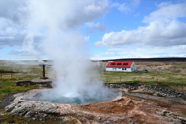
The Hveravellir geothermal field is the largest low-temperature geothermal field in Northern Iceland. It is limited to an area of 1600 m x 300 m, trending north to south and located on the western flank of the volcanic rift zone. There are six major hot springs, but numerous smaller warm and hot springs are found in the area. Most of the surface geothermal activity is located along faults and fractures, with reservoir temperatures being round 130 °C.
Baðstofuhver (bathroom hot spring) is the main geyser at Hveravellir, and the biggest one found in low-temperature fields in Iceland. It consists of a large bowl of approximately 8 m (26 feet) in depth. The recorded history shows three different stages. In its unmanipulated state during the 18th and 19th century eruptions had been very rare and less impressive. In 1904 the water level was lowered by 25 cm (9 in) by carving discharge channels into the geyser mound. The geyser responded with eruptions every few minutes, some of them up to 12 m (40 feet) high. Bursts reaching 25 m (80 feet) have been reported for later years. After utilisation of the water in 1970 the water level has been raised again with the result that major eruptions do no longer take place. In contrast, minor eruptions occur frequently today.
The water of the geysir contains different minerals, that are dissolved in the water reservoirs below the surface. The main mineral can been seen around the geyser, and the typical sulfur smell is in the air like almost everywhere in Iceland. The obtained mineral is called geysirit and consits of a substance, that is also used as a elixir when extracted from fossile algae.
To claim this cache as found, please answer the following questions, sending an e-mail via my GC-account:
- There is a special ring around the opening. Describe, what it looks like (pattern, colour, plain or rough). What material / substance could it be?
- Which temperature has the water according to the sign at the coordinates?
- Take your time to watch the eruptions. How many can you count in 3 minutes? Explain, how a eruption developes and how high the water gets. Are they all the same or different heights?
- OPTINONAL: A picture of you, your GPS at the location or just the geyser is welcome. (Please no pictures showing the sign!)
Logs without E-Mail answers will be deleted.
Sources: Wikipedia.com, Wikipedia.de, geology.com, geothermal-energy.org, volcanic-springs.com and DuMont Reisehandbuch Island