General Information and Warnings
Please use the tracks to reach this earthcache, there is no need to climb up the spoil heaps. It is a risk not only for you but for those below you if you climb on spoil heaps.
Here at Cwmorthin you will find a stunning glacial valley but geologically it can be confusing due to the vast amounts of slate mining and surface quarrying that have taken place here. The earthcaches on this trail focus on both the original glacial features of the valley, and also the interesting slate that has been exposed from underground by the workings. Always remember that the huge piles of slate you will frequently walk over and past were not placed here naturally, this is all the work of man. As you walk around, try and keep an image in your mind of how the valley would have looked before the slate was quarried.
Our earthcache trail keeps to the tracks around the old quarry and mine areas. The mines are extensive and should all be gated and locked. The mines were abandoned because they were too unsafe to work. It is not recommended to climb the spoil heaps or explore away from the paths as there could be hidden dangers, and it’s not recommended to let children or pets run off unsupervised. Also be aware that slate can have a very sharp edge and can cut very deeply, so please treat this area with the respect it requires.
Information about the Alpine fissure-veins
This earthcache is a little more of a complex geological feature than the others on the trail and this is reflected in the rating, however, I have tried to simplify the geology as much as possible. It is important to read and understand the listing to appreciate the feature here.
Surface quarrying generally did not occur in this area – the good quality Ordovician slate was found in veins underground and it needed to be mined out. However, it is clear to see surface quarrying has occurred here, and it provides a spectacular vantage point of what lies just below the surface. Mining began in the area in 1810, and although large scale extraction stopped many years ago, some small scale operations still continued and it didn't actually completely finish here until 1997. This quarry was clearly one of the last operations. The slate here has been exposed much more recently and it allows you to see the slate in a freshly cut form; it is also a good place to see the stained slate.
Alpine fissure-veins are bodies of quartz and other minerals occupying brittle tensional fractures in relatively competent (hard) rock-units, generally occurring within a less competent (softer) host. Named after the famed occurrences in the Alps, from which huge crystals of quartz and other minerals have been produced, they are a widespread occurrence North Wales. They are syn-tectonic veins - that is, they were formed during the regional deformation and strain-related metamorphism that led to the formation of the slate itself.
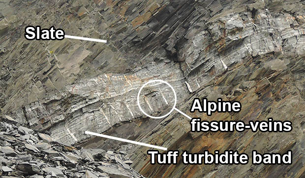
Here at Cwmorthin Quarry there is an excellent example of one you can see very clearly in the quarry face. The Middle Ordovician slate rock is interrupted by several tuff turbidite bands known to the miners as "cherts". These are distinctive, pale/dark grey banded rocks with a tough, splintery nature. They were formed by underwater flows of fine-grained debris erupted from nearby volcanoes. Alpine fissure-veins occur within the dykes, within brecciated slate and within the tuff-turbidites - particularly at Cwmorthin.
It is important that you are able to correctly identify the Alpine fissure-veins, so please refer to the diagram below. You will see a large prominent dark grey band laced with white quartize part way up the quarry face. You need to look more closely this band. Binoculars would be very helpful here to fully appreciate the feature. You will see lots of almost horizontal layers running across the quarry face in the same direction as the slate layers around it - but you will also notice what appear to be vertical lines. They clearly separate the continuous layers that you can see running across the quarry, and these vertical lines are the Alpine fissure-veins.
Long age during the Caledonian deformation, the land of North Wales was compressed under phenomenal pressure. Under these conditions, the clay-minerals making up the muddier sediments became soluble and readily recrystallised, becoming aligned at right-angles to the direction of maximum pressure. Thus the rocks developed a grain - a cleavage. Due to the flaky nature - like mica - of clay-minerals, rocks largely made up of them developed a particularly strong, pervasive, parallel cleavage, making them easily splittable into thin sheets. Thus were the foundations of the Welsh slate industry laid.
Whilst this process is going on, individual rock units deform according to their own properties, most importantly their competence. In geology, competence refers to the degree of resistance of rocks to either erosion or deformation in terms of relative mechanical strength. An incompetent rock is essentially more bendy, so for example, a fine-grained muddy rocks is relatively incompetent and can be squashed, folded and so on with relative ease as explained above. But a competent rock will not bend - it will either buckle, fault, or fracture So if you try and fold or compress a competent bed, you also end up creating tensional stresses which cause the bed to pull apart in a series of fractures. Try bending an eraser through 90 degrees. It will bend so far then it will start cracking across the axis of the bend. The same thing happens to competent rocks.
If an open fissure suddenly appears amidst all of this pressurised rock, it forms a low-pressure zone. Any nearby pressurised fluids will eagerly make their way into it. The fluids interact with the rock and hence carry various substances in solution which are then deposited as minerals.
Although Alpine fissure-veins often begin their existence as fibre-veins, where crystals grow in contact with both fissure walls as the fissure slowly opens, rapid fracture widening then leads frequently to open-space filling with well-formed (euhedral) crystals coating the sides of cavities. Mineral assemblages within Alpine fissure-veins tend to reflect the host rock mineralogy and geochemistry to an extent, a feature that suggests that the fluids responsible were in, or close to, chemical and/or thermal equilibrium with the host rocks. So where did the fluids come from? There are various possibilities, including the release of water during recrystallisation of clay minerals.
Although quartz may form larger crystals to several centimetres, most of the more exotic minerals from these localities are fine-grained. They are best studied using binocular or scanning electron microscopy. The mineral assemblages at each site are broadly similar but there are subtle differences. At Cwmorthin, early veining is again of a fibrous nature (quartz-calcite-titanite). Later, thin planar open cavities contain quartz, anatase, synchysite and xenotime with minor albite, apatite, rutile, brookite, galena and pyrite.
Why are Alpine fissure-veins so interesting? There are a number of reasons. Firstly the mineralogy itself has attracted worldwide interest for years and continues to do so. Secondly, because they are interesting in structural terms because they were formed as a response to deformation. Thirdly, because the veins formed at the time of the deformation and strain-related metamorphism that created the slate, they are of interest because some of the minerals may contain isotopes which will allow dating to be done.
Logging Requirements (Questions to Answer)
Please e-mail me the answer to the questions via my profile. I do read all answers and try to reply to them all; I may not reply immediately so please do not wait for a reply before posting your find. Ideally, please send your answers at the same time you submit your log, or within a few days of your visit. I do check answers have been sent for every log, if you do not send answers within a week your log may be deleted. You are not expected to have any previous geological knowledge, your best attempt at the answers is all that is required.
1. Estimate the height and length of the main exposed dark grey turbidite band containing the Alpine fissure-veins.
2. Do the the Alpine Fissure-veins go all the way from the top of the turbidite band to the bottom? If not what do they do and what does this tell you about the formation period?
3. Is there a great variation in the size of the Alpine fissure-veins? If you see a difference in size, please explain why this might have happened? The information in the text above might help answer this question.
4. Please look at the slate in the main quarry face and look for Alpine fissure-veins. Can you spot any? Please complete the following sentence by inserting the words 'competent' and 'incompetent' to show you understand why you see the veins.
"The Alpine fissure veins have occured in the grey turbidite band because the rock they are made of is ____________________. However, the veins have not occured in the slate because it is ____________________.
We always like to see photographs of you and/or your GPS device with the geological features - plus this also provides additional proof of your visit, so please include one with your log if you wish.
This cache has been produced especially for the