General Information and Warnings
Here at Cwmorthin you will find a stunning glacial valley but geologically it can be confusing due to the vast amounts of slate mining and surface quarrying that have taken place here. The earthcaches on this trail focus on both the original glacial features of the valley, and also the interesting slate that has been exposed from underground by the workings. Always remember that the huge piles of slate you will frequently walk over and past were not placed here naturally, this is all the work of man. As you walk around, try and keep an image in your mind of how the valley would have looked before the slate was quarried.
The Rhosydd Geology Trail follows the track up the south side of the lake and back around to Plas Cwmorthin, a former quarry managers mansion. It extends a little further on a less used path that can be boggy in places, the rangers have asked that you return via the same route from the farm, please don't try and cross the boggy area between the farm and the old mines. This trail is generally further away from the mines and spoil heaps but you will pass old buildings that may be unsafe and there could be other hidden dangers - please take appropriate care. Also be aware that slate can have a very sharp edge and can cut very deeply, so please treat this area with the respect it requires.
Information about the Volcanic Rocks
The purpose of this earthcache is to do a focused study on the volcanic rocks that dominate much of the valley here at Cwmorthin.
Although Cwmorthin largely consists of relatively mechanically-weak siltstones, mudstones and slates - the slates being metamorphosed siltstones and mudstones (of the mid to upper Ordovician age) - it's impossible to miss the impressive sight of the more resistant intrusive and extrusive igneous rocks (dolerite, felsite and rhyolite) such as the stone you see in front of you here.
Igneous rocks get their name from the Latin word ignis, meaning "fire". They form from magma and can be referred to as volcanic rocks. Under the surface of the Earth the magma is kept liquid by high temperature and high pressure. As a volcano erupts hot magma reaches the surface. Afterwards the lava rapidly cools down and solidifies. The crystals formed by cooling magma are usually small. Magma doesn't always reach the surface. Sometimes it is trapped underground in pockets of other rocks. In this case the magma cools down more slowly forming larger crystals and coarse-grained rocks. How the rocks form will depend not only on the different cooling temperatures of the magna but also its chemical composition.
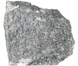
Dolerite
Dolerite is a dark-colored igneous rock. It is a subvolcanic rock, in composition it is equivalent to volcanic basalt or plutonic gabbro. Dolerite dikes and sills are typically shallow intrusive bodies and are often fine grained or so fine grained the grains can't be seen by the untrained eye. Dolerite is a common rock type. It occurs mostly in shallow intrusions (dikes and sills) of basaltic composition.
----------------
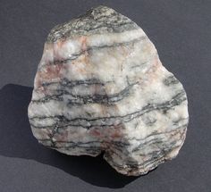
Felsite
Felsite is a dense, fine-grained, igneous rock consisting typically of feldspar and quartz, both of which may or may not appear as distinct crystals. Felsite is a field (general) term for a light colored rock that typically requires detailed examination or chemical analysis for more precise definition. Colour is generally white through to light gray, or red to tan, although they can include almost any colour. The mass of the rock consists of a fine-grained matrix of materials, particularly quartz, sodium and potassium feldspar. This rock is typically of extrusive origin, e.g. it is formed by compaction of fine volcanic ash, and may be found in association with rhyolite as it can be in this valley. In some cases, it is sufficiently fine-grained for use in making stone tools.
----------------
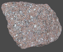
Rhyolite
Rhyolite can be considered as the extrusive equivalent to the plutonic granite rock, and consequently, outcrops of rhyolite may bear a resemblance to granite. They have a high content of silica and low iron and magnesium contents. It may have any texture including glassy, aphanitic (which means they are so fine-grained that their component mineral crystals are not detectable by the unaided eye) or porphyritic (which means there is a distinct difference in the size of the crystals, with at least one group of crystals obviously larger than another group). This may depend on how quickly the rock cooled.
----------------
These igneous rocks have left an huge imprint on the landscape. For the more technically minded, note the steep cliffs of Allt y Ceffylau, north of Llyn Cwmorthin, the east-facing cliffs below the summit of Foel Ddu, west of the lake, and the prominent cliffs of Craig Nyth-y-Gigfran and Craig yr Wrysgan-Clogwyn yr Oen to the north and north-west of Tanygrisiau. The cliffs of Craig Nyth-y-Gigfran and Craig yr Wrysgan-Clogwyn yr Oen correspond to the outcrop of the Moelwyn Volcanic Formation (extrusive lavas, volcanic ash, and flows of volcanic debris; the product of submarine eruptions) and intrusive rhyolite sills. Furthermore, this suite of resistant igneous rocks accounts for the pronounced narrowing of that part of the valley between the lake and Dolrhedyn.
Logging Requirements (Questions to Answer)
Please e-mail me the answer to the questions via my profile. I do read all answers and try to reply to them all; I may not reply immediately so please do not wait for a reply before posting your find. Ideally, please send your answers at the same time you submit your log, or within a few days of your visit. I do check answers have been sent for every log, if you do not send answers within a week your log may be deleted. You are not expected to have any previous geological knowledge, your best attempt at the answers is all that is required.
1. Estimate the approximate dimensions (thickness, length and width) of the igneous volcanic rock in front of you. This is to give you an idea of the large continuous size you can find when looking at rock formed in this way.
2. Run your hand over the angled, flat top surface and take a close look at the grains making up the rock. The top has been smoothed by the glacier, so also look at the side. Please describe the texture and colour. How big are the crystals making up the rock? It can be quite hard for the untrained eye to distinguish the difference, but can you please tell me which of the three rock types (dolerite, felsite and rhyolite) you believe this to be?
3. Clearly the left hand section of the rock is missing, it would have originally been much bigger. This may have been due to a geological event such as a glacier plucking part of the rock away, or due to the actions of man. There is an obvious piece of evidence that can clearly be seen on the rock. What is it, and what do you think happened to the missing bit of rock?
We always like to see photographs of you and/or your GPS device with the geological features - plus this also provides additional proof of your visit, so please include one with your log if you wish.
This cache has been produced especially for the