Lake Bellfield is situated on Fyans Creek in the Fyans Creek Valley. The structure of the valley was recognised as an excellent location for the construction of a water storage reservoir. Lake Bellfield was thus constructed in the 1960's (finished in 1966), when the area was dammed, inundating 445 hectares of land with water. In 2000, the dam wall was deemed inadequate to meet current flood safety standards, and a rehabilitation project commenced. A higher embankment was constructed to raise the wall height. A concrete parapet was built along the wall. The spillway discharge channel was deepened by 3.4 metres. The maximum capacity of Lake Bellfield is now 78,560 Megalitres. It is the primary source of water supply to much of the Wimmera Mallee Pipeline system and supplies the towns of Halls Gap and Pomonal. The views you see at this cache are of Fyans Valley, Mt William and the Wonderland Ranges. The Lake continues to be a popular location for picnicking, fishing, swimming and kayaking/canoeing. Please be careful walking on the dam wall. Obey the signs and do not climb down the embankment.

GEOLOGY
What is sandstone?
The rock material found in this area - and many other areas in the Grampians - is comprised of sandstone. Sandstone is a sedimentary rock composed of sand-sized grains of mineral, rock or organic material. It also contains a cementing material that binds the sand grains together and may contain a matrix of silt- or clay-size particles that occupy the spaces between the sand grains. Like sand, sandstone may be any color, but the most common colors are tan, brown, yellow, red, grey, pink, white and black.
What is sand and how does it become sandstone?
The word "sand" in sandstone refers to the particle size of the grains in the rock rather than the material of which it is composed. Sand-size particles range in size from 1/16 millimeter to 2 millimeters in diameter. Sandstones are rocks composed primarily of sand grains. The grains of rock in sandstone have been reduced to "sand" size by weathering and transported to their depositional site by the action of moving water, wind or ice. Their time and distance of transport may be brief or significant and during that journey the grains are acted upon by chemical and physical weathering.
Requirements to log this cache
The posted coordinates take you across the Lake Bellfield embankment, which is 745m long. An embankment is a raised bank or wall that is built to carry a roadway or hold back water.
Q1. Describe the colours and average size of the rocks on the sides of the embankment. What type of rock has been used here?
Q2. What colour is the water in Lake Bellfield? Describe the water clarity (eg. clear or cloudy).
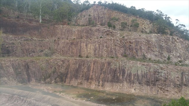
Keep walking to the end of the dam wall to WP2, which is at a crescent shaped wall, called a spillway. A spillway is a structure constructed to provide safe release of flood waters from a dam to a downstream area, normally the river on which the dam has been constructed. It prevents damage to the main dam wall during a flood. Look to the section of the spillway wall that is on the left hand side. The levels are very pronounced here. The following questions relate to this section of the wall.
Q3. Describe the colours, textures and distinctive features of the rock surface. How does the rock here at WP2 appear similar or different to the rock at WP1? Do you think that the excavated spillway rock could have been used for the embankment rock?
Please send your answers to larafolk, through message centre or email.
You may log your find as soon as you have visited the Earthcache and answered the questions. However, you need to send through your answers within 7 days, or your find log will be deleted.
We hope you enjoyed this Earthcache & we'd love you to post a photo of your adventure.
Information sourced from Grampians Wimmera Mallee Water (GWMWater) and geology.com