Wetlands are areas that seasonally or permanently saturated with surface water or ground water and support plants that can grow in wet conditions. North Carolina wetlands include swamps, pocosins, tidal flats and marshes. Comparable to rain forests and coral reefs, wetalns are one of the most biologically productive ecosystems in the world.
Unfortunately, many of our natural wetlands have disappeared due to growth and development. For this reason, man-made or constructed storm water wetlands are often installed to mimic the natural functions or wetlands that have been lost.
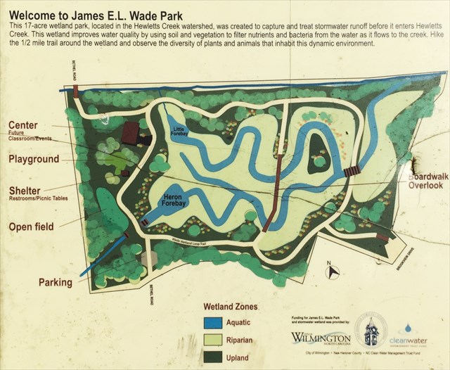
The James E L Wade Park storm water wetland is a 12 acre wetland designed to cleanse polluted runoff from approximately 590 acres or 10% of Hewletts Creek Watershed.
Wetland Benefits
Reduce Flooding. Wetlands function as a natural sponge saoking up excess water during heavy rainfall. Water is stored and slowly released into adjacent creeks and groundwater. Wetlands help prevent flooding.
Improve Water Quality. Wetlands naturally filter water by straining sediment, debris, and organic materials. Wetland plants and soils take up nutrients, heavy metals and bacterial pollution from water.
Provide Nurseries and Nesting Areas. Wetlands function like nurseries because they provide shelter, protection, and food for wildlife. Wildlife are dependent on wetlands for feeding, breeding and nesting. Wetlands are also important resting grounds for birds during migration.
Mosquito Control. Wetlands provide powerful mosquito control. Diverse plants and water levels in the wetland provide habitat for many natural predators of mosquitoes including frogs, dragonflies, damselfie, and mosquito fish.
Vital Links
Wetlands are important elements in watershed because they serve as a vital link between land and water. It serves to clean polluted storm water runoff. reduce flooding and erosion, recharge groundwater supplies, enable recreational opportunities and provide a critical habitat for birds, fish and wildlife.
Everyone lives in a watershed. New Hanover County is one of the most densely populated counties in North Carolina. With the increase in population and development, it's more important than ever to keep our watersheds healthy.
You don't have to live near a waterway to have significant impact of it. The amount of polluted runoff and how we treat the resources in our watershed, all have a direct impact on the ability of our waterways to support activities like shelfishing, swimming, fishing, wildlife habitat, and drinking water supplies. What happens in your own backyard directly impacts our waterways.
What is watershed?
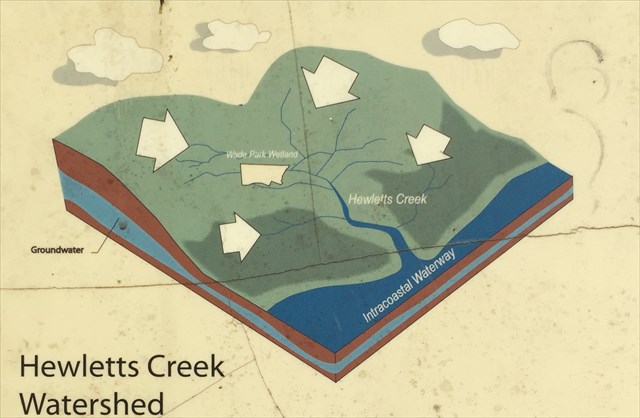
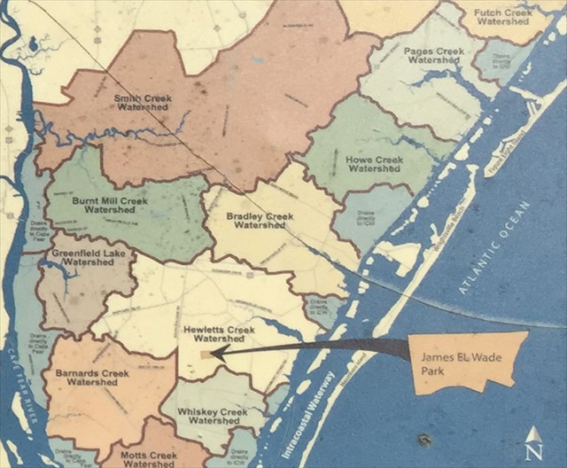
A watershed is the area of land that drains water to a particular creek, river or ocean. Watersheds are determined by the slope or natural lay of the land, meaning all water drains to the lowest point. Approximately 7,000 acres of land drains into Hewletts Creek which eventually flows into the Intracoastal Waterway and Atlantic Ocean.
Storm water runoff is the #1 source of water pollution. When water flows across impervious or hard serfaces, such as driveways, streets, parking lots and rooftops, it's prevented from naturally soaking into the ground. Instead, it picks up and carries pollutants such as pet waste, fertilizers, pesticides, litter and auto fluids, through the watershed and into a water body such as Hewletts Creek. These pollutants harm wildlife and impact activities like fishing, swimming and the quality of our drinking water.
From the starnewonline.com from an article written in January 2009
It's the sixth largest city-maintained park, and the first to open in the city since Halyburton Park on South 17th Street, which was added in 2004. With Wade Park, the city now maintains 30 parks, including neighborhood and citywide parks ranging in size from 0.1 acres to the 250-acre Greenfield Park.
Wade Park is the result of a partnership between Wilmington, New Hanover County and the state, said Amy Beatty, the city's recreation manager.
Formerly known as the "Dobo property," New Hanover County bought the land in 2005 with money provided by the N.C. Clean Water Management Trust Fund. The goal was to improve the condition of Hewletts Creek, which has been plagued by poor water quality, by working with the city to construct a wetland on the property.
The city's Stormwater Services Division installed the 12-acre wetland beginning in 2006. The project diverts runoff from two outfalls bordering the property into the wetland to help remove pollutants before the water enters Hewletts Creek.
Completed in 2007, the wetland treats a drainage area of approximately 590 acres, 10 percent of the Hewletts Creek Watershed.
With the stormwater project complete, the city began developing the site as a park last spring. That work, which cost the city $688,000, was completed this month.
In all, the state, county and city spent about $5 million buying the land, building the wetland and creating the park.
The park is named for named for former mayor and community activist James E. L. Wade, who served on City Council from 1945 to 1963.
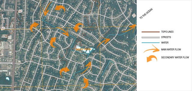
In the topographical map above, you will see the large communities that are surrounding this park. From the information above about how water flows in manmade habitats, you can see with all the new housing developments, the natural flow of the water was disturbed. This park (formerly know as the dobo property) was a natural low land point. With the added manmade water ways (shown on the topo map), you can see how the water the comes from the communities around the park flows into the drainage ditches and into the park to be filtered out and flows towards the ocean.
Although this was a natural wetland before 2004, the city deveolped it into a larger wetland and park by adding the waterways to direct more water into this area that was formerly not able to be built upon turning this into a quality park for our enjoyment.
To get credit for this earthcache, email the owner the name and GC# with the answers below.
1. The water level and flow changes quite frequently and occasionally reverses in the forebay areas in the park. Locate one of the 3 bridges (one at ground zero) using the map above or onsite, take a coordinate reading of where you are at and decide if the water is flowing and in what direction? If you can't tell if it is moving, use something like a blade of grass on the water's surface to see if the water is moving.
2. Using the text and images above along with the signs in the park, describe the human and animal benefits and usages this park allows in your own words.
3. Optional. Post a picture with yourself but not the answers.
Resources: plaques and signs put up by the county.
This park starts the 15 mile Gary Shell Cross-City Trail. Bring your bike and have a nice day.