The Geology Beneath the Castle
The coastline around Tintagel is interesting because it is composed of old Devonian slate. About a mile southwards from Tintagel towards Treknow the coastline was quarried extensively for this hard-wearing roofing surface. Slate is a metamorphic rock, formed under great pressure from what was originally mudstone.
Trevillet Slate (also known as Tintagel Slate) is the name given to the local slate found here and has been extracted from several quarries including the nearby works at Trevillet. The slates are distinctly greyish-green in colour with brown oxide coatings on their cleavage and joint planes. Cliffside Quarries between Tintagel and Trebarwith Strand provided a source of slate back to the 17th century. Other quarries in the Tredorn Slate Formation occur to the west of Boscastle. These yielded finer and harder greenish grey slates from quarries at the base of the sea cliff. Extracted slates were hauled by cable to the cliff tops and then exported via Boscastle Harbour, although some were used locally.
One of the particularly interesting effects of the presence of this slate is colour of the sea. The turquoise green water around this coast is caused by the slate/sand around Tintagel which contains elements of copper - the strong sunlight turns the water a light turquoise green colour in warm weather. The rocks contain various metal ores in small amounts: a few of these were mined in the Victorian period. Because some of the these metal ores include iron and other metals, the slate can appear as though it is covered in rust – this is the effect of the metallic minerals rusting when they come into contact with water. Because the metal content in the rocks varies the effect can be stronger in different patches on the rock, or the rust can run and gather in a particular place.
Coastal erosion is the wearing away of land and the removal of beach or dune sediments by wave action, tidal currents, wave currents, drainage or high winds. Waves, generated by storms, wind, or fast moving motor craft, cause coastal erosion, which may take the form of long-term losses of sediment and rocks, or merely the temporary redistribution of coastal sediments; erosion in one location may result in accretion (the coast extending) nearby.
Both of the earthcaches here fall within the Tintagel Cliffs SSSI (a Site of Special Scientific Interest), designated for both its maritime heaths and geological features. Many thanks to Natural England and English Heritage for their support in the publication of these earthcaches. Please be aware of this protected state of this coastline and don’t interfere with the rocks or plantlife when you explore. Both earthcaches are on public footpaths/beaches, you do not need to pay to enter the castle.
Logging Requirements (Questions to Answer)
Please e-mail me the answer to the questions via my profile. I do read all answers and try to reply to them all; I may not reply immediately so please do not wait for a reply before posting your find. Ideally, please send your answers at the same time you submit your log, or within a few days of your visit. I do check answers have been sent for every log, if you do not send answers within a week your log may be deleted. You are not expected to have any previous geological knowledge, your best attempt at the answers is all that is required.
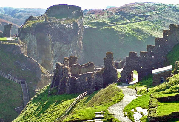
The given co-ordinates take you to a point on the coastal footpath where you get a stunning view of the rock beneath the mainland section of the castle, immediately in front of you. This is the bit we are interested in, the island section of the castle is not relevant to this earthcache.
Question one asks some simple observational questions about the geology of the rock face you see. The second question focuses on erosion and how long the castle here might last. The information in the listing will help you.
Question 1
The first thing you notice when you view the rock is the amount of different colours on the face. There are three distinct sections when you view the rock in terms of colour.
i) Focus on the slate rock at the top directly beneath the walls of the castle. Describe the colour, describe the layering. Are the layers thin or thick? Are they more pronounced than the layers lower down? Do you notice any signs of a green hue that might suggest the presence of copper?
ii) Move your attention below this rock. The colour has changed completely. Describe the colour you see here. Do you think this striking colour is because of a mineral in this section of slate, or do you think there is a fault or presence of another rock? Why?
iii) Move your attention now to the lower section of the cliff. This is rock is slate but it looks different to the slate at the top as it was formed at a different time. Describe the colour and the difference in smoothness. Why might the texture be different? Do you notice any signs of a green hue that might suggest the presence of copper?
Question 2
The castle was originally built in the 13th century and has stood here for many years - but the cliffs here are exposed and the walls are close to the edge.
i) Look at the castle. Has any of it already been lost to the collapse of the cliffs?
ii) Look at the cliffs. Do you think there is any risk of further collapse, and how immediate is the threat? Do you think this bit of castle is at greater threat than the bit on the island?
iii) Look at cliff below the path just below the shadow of the castle. You can see this by standing the other side of the path curve, there is no need to lean over the wall. You will see something the authorities have done to the cliff just below the path. Describe the man made intervention and what you think it might do to help keep the path where it is today.
We always like to see photographs of you and/or your GPS device with the geological features - plus this also provides additional proof of your visit, so please include one with your log if you wish.
Please enjoy your visit to Tintagel Castle.