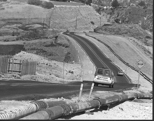
This is a photo taken of Palos Verdes Drive South. The above ground pipes are visible and remain there today. Image courtesy of PVLD Local History Center. Portuguese Bend Landslide report n.d, Accession 2013-15 (unprocessed), Palos Verdes Library District, Local History Center.
The Palos Verdes Peninsula has a deep geological history which goes all the way back to when the Peninsula was created. When Palos Verdes was an island, marine terraces were formed and shifts in the land have caused the layers of rock to slide. The Portuguese Bend Landslide Complex stretches over the southern part of the Peninsula and includes the Portuguese Bend, Flying Triangle, Abalone Cove, and Klondike Canyon landslides.
In 1956, Los Angeles County tried to extend Crenshaw Boulevard to connect with Palos Verdes Drive South. The city stored 300,000 cubic yards of dirt from the extension project on what happened to be the top of the Portuguese Bend landslide, causing the ancient slide to be reactivated. Rainwater also entered the cut and caused the land to move further, resulting in the destruction of 102 homes and the Portuguese Bend Club house by 1965. The city has tried many ways to control the landslide movement, including installing dewatering wells and grading. Every once in a while they repave Palos Verdes Drive West to keep it safe for travel.
The Abalone Cove Landslide was stabilized by dewatering after it began moving in 1978. The RPV City Council adopted a Urgency Ordinance which placed restrictions on construction projects in the area. The Abalone Cove Landslide Abatement District was formed in 1981 and aims to help control the landslide. Similarly, the Klondike Canyon Landslide Abatement District was formed in 1982 and works to maintain dewatering wells that help control the landslide. The 50 acre Klondike Canyon Landslide began moving in 1979 and the Flying Triangle Landslide began in 1980. Due to the ongoing nature of these slides, there are many building restrictions within the Landslide Moratorium Area. The moratorium area was first established in September 1978 with the Urgency Ordinance, but was later expanded in 1981 to include the Klondike Canyon and Flying Triangle landslides.
For more geological information about the Portuguese Bend Landslide, you can see the Portuguese Bend Landslide Earthcache
This geocache was placed with the permission of the City of Rancho Palos Verdes