Geologists identify erratics by studying the rocks surrounding the position of the erratic and the composition of the erratic itself. Erratics are significant because:
- They can be transported by glaciers, and they are thereby one of a series of indicators which mark the path of prehistoric glacier movement. Their lithographic origin can be traced to the parent bedrock, allowing for confirmation of the ice flow route.
- They can be transported by ice rafting. This allows quantification of the extent of glacial flooding resulting from ice dam failure which release the waters stored in proglacial lakes such as Lake Missoula. Erratics released by ice-rafts that were stranded and subsequently melt, dropping their load, allow characterization of the high-water marks for transient floods in areas like temporary Lake Lewis.
- Erratics dropped by icebergs melting in the ocean can be used to track Antarctic and Arctic-region glacial movements for periods prior to record retention. Also known as dropstones, these can be correlated with ocean temperatures and levels to better understand and calibrate models of the global climate.[1]
Formation of erratics
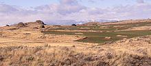
Multiple erratics on the terminal moraine of the Okanagon Lobe. Cascade mountains in the background.
The term "erratic" is commonly used to refer to erratic blocks, which Geikie describes as: "large masses of rock, often as big as a house, that have been transported by glacier-ice, and have been lodged in a prominent position in the glacier valleys or have been scattered over hills and plains. And examination of their mineralogical character leads the identification of their sources…".[2] In geology, an erratic is material moved by geologic forces from one location to another, usually by a glacier.
Erratics are formed by glacial ice erosion resulting from the movement of ice. Glaciers erode by multiple processes: abrasion/scouring,plucking, ice thrusting and glacially-induced spalling. Glaciers crack pieces of bedrock off in the process of plucking, producing the larger erratics. In an abrasion process, debris in the basal ice scrapes along the bed, polishing and gouging the underlying rocks, similar to sandpaper on wood, producing smaller glacial till. In ice thrusting, the glacier freezes to its bed, then as it surges forward, it moves large sheets of frozen sediment at the base along with the glacier. Glacially-induced spalling occurs when ice lens formation with the rocks below the glacier spall off layers of rock, providing smaller debris which is ground into the glacial basal material to become till.[3][4]
Evidence supports another option for creation of erratics as well, rock avalanches onto the upper surface of the glacier (supraglacial). Rock avalanche–supraglacial transport occurs when the glacier undercuts a rock face, which fails by avalanche onto the upper surface of the glacier. The characteristics of rock avalanche–supraglacial transport includes:[5]
- Monolithologic composition - a cluster of boulders of similar composition are frequently found in close proximity. Commingling of the multiple lithologies normally present throughout the glaciated basin, has not occurred.[5]
- Angularity - the supraglacially transported rocks tend to be rough and irregular, with no sign of subglacial abrasion. The sides of boulders are roughly planar, suggesting that some surfaces may be original fracture planes.[5]
- Great size - the size distribution of the boulders tends to be skewed toward larger boulders than those produced subglacially.[5]
- Surficial positioning of the boulders - the boulders are positioned on the surface of glacial deposits, as opposed to partially or totally buried.[5]
- Restricted areal extents - the boulder fields tend to have limited areal extent; the boulders cluster together, consistent with the boulders landing on the surface of the glacier and subsequently deposited on top of the glacial drift.[5]
- Orientations - the boulders may be close enough that original fracture planes can be matched.[5]
- Locations of the boulder trains - the boulders appear in rows, trains or clusters along the lateral moraines as opposed to being located on the terminal moraine or in the general glacial field.[5]
Glacier-borne erratic

Two icebergs clearly retain fragments of the
moraine (rock debris) that forms a dark line along the upper surface of the glacier. The inclusion of the moraine illustrates how land-based rocks and sediment are carried by ice.
Erratics provide an important tool in characterizing the directions of glacier flows, which are routinely reconstructed used on a combination of moraines, eskers, drumlins, meltwater channels, and similar data. Erratic distributions and glacial till properties allow for identification of the source rock from which they derive, which confirms the flow direction, particularly when the erratic source outcrop is unique to a limited locality. Erratic materials may be transported by multiple glacier flows prior to their deposition, which can complicate the reconstruction of the glacial flow.[6]
Ice-rafted erratic
Glacial ice entrains debris of varying sizes from small particles to extremely large masses of rock. This debris is transported to the coast by glacier ice and released during the production, drift and melting of icebergs. The rate of debris release by ice depends upon the size of the ice mass in which it is carried as well as the temperature of the ocean through which the ice floe passes.[7]
Sediments from the late Pleistocene period lying on the floor of the North Atlantic show a series of layers (referred to at Heinrich layers) which contain ice-rafted debris. They were formed between 14,000 & 70,000 years before the present. The deposited debris can be traced back to the origin by both the nature of the materials released and the continuous path of debris release. Some paths extend more than 3,000 kilometres (1,900 mi) distant from the point at which the ice floes originally broke free.[7]
The location and altitude of ice-rafted boulders relative to the modern landscape has been used to identify the highest level of water in proglacial lakes (e.g., Lake Musselshell in central Montana) and temporary lakes (e.g., Lake Lewis in Washington state. Ice-rafted debris is deposited when the iceberg strands on the shore and subsequently melts, or drops out of the ice floe as it melts. Hence all erratic deposits are deposited below the actual high water level of the lake; however the measured altitude of ice-rafted debris can be used to estimate the lake surface elevation.
This is accomplished by recognizing that on a fresh-water lake, the iceberg floats until the volume of its ice-rafted debris exceeds 5% of the volume of the iceberg. Therefore, a correlation between the iceberg size and the boulder size can be established. For example, 1.5-metre (4.9 ft) diameter boulder can be carried by a 3-metre (9.8 ft) high iceberg and could be found stranded at higher elevations than a 2-metre (6.6 ft) boulder which requires a 4-metre (13 ft) high iceberg.[9]
Large erratics
Glacial erratic
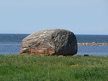
Ehalkivi with overground volume 930 cubic metres (1,220 cu yd) (weight approximately 2,500 metric tons or 2,800 short tons) in
Estonia
Large erratics consisting of slabs of bedrock that have been lifted and transported by glacier ice to subsequently be stranded above thin glacial or fluvioglacial deposits are referred to as glacial floes, rafts (schollen) or erratic megablocks. Erratic megablocks have typical length to thickness ratios on the order of 100 to 1. These megablocks may be found partially exposed or completely buried by till and are clearly allochthonus, since they overlay glacial till. Megablocks can be so large that they are mistaken for bedrock until underlying glacial or fluvial sediments are identified by drilling or excavation. Such erratic megablocks greater than 1 square kilometre (250 acres) in area and 30 metres (98 ft) in thickness can be found on the Canadian prairies, Poland, England, Denmark and Sweden. One erratic megablock located in Saskatchewan is 30 by 38 kilometres (19 mi × 24 mi) (and up to 100 metres or 330 feet thick). Their sources can be identified by locating the bedrock from which they were separated; several rafts from Poland and Alberta were determined to have been transported over 300 kilometres (190 mi) from their source.[10]
To claim this earthcache, please e-mail me the answers to these questions via my profile
Answers should be sent in at time of logging, if not before, thank you.
Q1. North Delta was formed about the same time that this erratic was deposited here. Looking at the configuration of North Delta and area, on the map, can you see any large area features that suggest the direction this erratic came from?
Q2. Of what mineral is this principally composed of?
Q3. Striations on erratics were usually made by scratching and gouging, INTO the rock surface, as the rock was pushed along the ground by the ice, during the ice age. What do you think caused the two RAISED striations, on the 'head' and 'tail'?
Do they confirm the direction you believe the erratic came from?
A photograph of you and /or your GPS/phone at GZ, is optional, but can be posted along with your log.
Earthcaches come under their own guidelines....all logged 'Finds' must be deleted, if the requirements are NOT met. I hope you understand.