Ladye Bay- a Coastal Cove EarthCache
WimpyKid1: Archiving - thanks to all that found
Ladye Bay- a Coastal Cove
-
Difficulty:
-

-
Terrain:
-

Size:  (other)
Please note Use of geocaching.com services is subject to the terms and conditions
in our disclaimer.
Ladye Bay is a secluded west-facing cove along the Somerset Coast, on the outskirts of Clevedon (accessible along the coast path). It has been subjected to coastal processes from the Severn Estuary.
Beware: Ladye Bay is on the Severn Estuary coast and is subjected to huge tidal changes, including the tide coming in quick and rip currents. Use common sense when attempting this Earthcache, and if it looks unsafe to access the beach, don't do it!

This Earthcache explains the processes that have occurred to create the Ladye Bay that we see today.
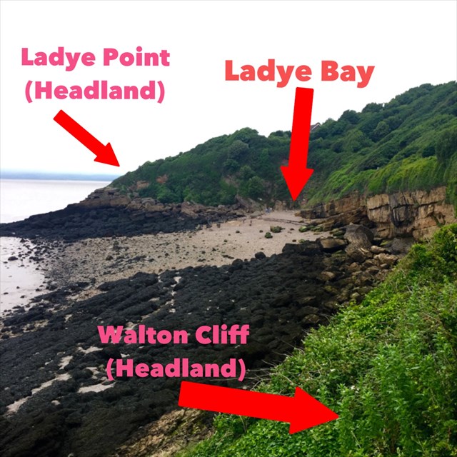
The Bay is sandwiched between the Ladye Point and Walton Cliff headlands. The bay has dipping Devonian (Jurassic) sandstone and siltstone cliffs and a raised pebble beach (formed in the Pleistocene era).
Access to the beach and Bay is down a set of steps, just off of the coast path.
There are various coastal processes that have created the Ladye Bay that we see today:
Headlands and Bays
Ladye Bay is a classic example of headlands and bays. Naturally, there are different vertical bands of rock along the coast which range in terms of resistance: clays and chalk cliffs are soft and less resistant to, say, limestone cliffs. The difference in resistance means that when the waves erode the cliffs by hydraulic action (sheer force of water pushing on rocks), the less resistant rocks are eroded quicker than the more resistant ones:

The inlet that is formed (made of softer rock) is known as a bay. The two outcrops (made of harder rock) are known as headlands. For Ladye Bay, the headlands are made from siltstone and the bay is made from Devonian sandstone.
 This photo was taken at Walton Cliff, a headland. This is waypointed if anyone wants to have a look there (there are some very good photo opportunities at this location!)
Raised Pebble Beach
A raised beach is, as the name suggests, a beach where all or part of it is above sea level. As the photo shows, the beach is on an incline. During normal tidal conditions, the highest extent of the waves will not cover the whole beach. In the photo above, you can see a line of seaweed that marks the highest extent of the waves.
This beach formed like normal beaches do, but started forming during the Pleistocene, at the time of the last Ice Age. The sea level would've been much higher and therefore eroded the cliff to produce small fragments (which became pebbles) and larger boulders which produced the current beach sediment. Due to climatic changes and isostatic changes (land sinking and rising due to gaining and losing weight), the sea level has since dropped to present day conditions, where the sea level is normally below the highest point of Ladye Bay.
To claim a find on this Earthcache, you must answer the questions below in an email/message to me within 24 hours of logging a find. Any drastically wrong or incomplete answers or any logs from a cacher without sent answers risks their log being deleted. Any photos that reveal answers will also be deleted.
1) What is the difference in height between the top of Ladye Bay (by the steps) and the shore at the time that you visited?
Some GPSs have an altitude feature to help you measure the height change. If not then guess, but let me know that you guessed. Also tell me if the tide was in or out at the time.
2) Have a look at the pebbles on the beach. Describe their size and smoothness. How does the size of the rocks change as you go closer to the shore and why do you think this is?
3) You should see large boulders on the north and south sides of the beach.(waypointed) How do you think they got there?
4) To prove you visited:
a) How many steps are there between the coastal path and Ladye Bay?
b) What is the name on the bench at Waypoint 2?
Photos of you/GPS at Ladye Bay without revealing the answers would be nice to see, but are optional.
Unfortunately, this Earthcache is unsuitable for wheelchair users due to steps and obvious uneven terrain of the beach.
As part of the 13th International Earthcache Day (October 2015) I challenged myself to place an Earthcache every month until Earthcache day 2016, kicking it off with GC62T8F. This Earthcache is number 9 in that challenge (June 2016).
Additional Hints
(No hints available.)
Treasures
You'll collect a digital Treasure from one of these collections when you find and log this geocache:

Loading Treasures