A hugh THANK YOU to GCEdo, who helped me a lot, creating my first Earthcache!
Answers to the questions should be send either in Croatian, English or German language.
Logs without an email, containing the answers, will be deleted without further notice.
Hrvatski 
Na izlistanim koordinatama naći ćete se na zadarskoj obali. Zadar je drevni grad koji se nalazi u središnjem dijelu hrvatskog dijela jadranske obale. Zadar se po prvi puta javlja u 9. stoljeću prije nove ere, kao naselje ilirskog plemena Liburni. Karakterizira ga bogata povijest i spomenici culture.
S obzirom da se nalazi na obali, ovaj EarthCache će Vas naučiti neke osnovne principe o morskim valovima i njihovom utjecaju na obalu. Također ćete promotriti interakciju valova s jednim vrlo posebnim instrumentom.
Za odgovaranje na neka pitanja će Vam trebati prazna boca, pa stoga trebate praznu bocu ponijeti sa sobom.
Morski valovi se javljaju u gornjem sloju mora. Oni su rezultat vjetra I geoloških učinaka. Val može putovati i više od tisuću kilometara prije nego dođe do obale. Veličina vala može varirati od malog mreškanja do velikih cunamija.
Formiranje valova:
Valovi u moru su uzrokovani s tri glavna faktora:
- Brzinom vjetra
- Udaljenošću preko koje vjetar puše
- Trajanjem puhanja vjetra nad površinom mora
Veličina vala ovisi o svakom od ova tri faktora, te što je svaki factor veći, to je veći i val.
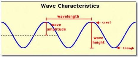
Svojstva i karakteristike valova (Slika 1)
- Vrh vala: točka vala s maksimalnom visinom, vrhunac valnog ciklusa.
- Dol vala: suprotno od vrha vala, minimalna visina vala, najniža točka valnog ciklusa.
- Visina vala: udaljenost između vrha i dola vala.
- Valna amplituda: udaljenost od razine mora do vrha vala.
- Valna duljina: udaljenost između vrhova dvaju valova
- Valna frekvencija: broj valova koji prolaze određenu fiksnu točku u određenom vremenskom razdoblju. Frekvencija se izražava u jedinici broja valova u sekundi ili broja ciklusa u sekundi. Druga jedinica za frekvenciju je herc (skraćeno Hz), pri čemu je 1 Hz ekvivalent 1 ciklusu u sekundi.
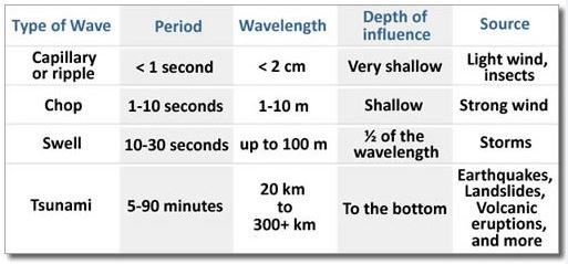
Vrste valova (Slika 2)
Vrste valova koje se mogu uočiti na ovoj lokaciji:
- Kapilarni valovi: Vrlo mali valovi s valnim duljinama manjim od 2 cm. Ovi valovi su prvi koji nastaju kada vjetar puše iznad površine mora, a nastaju uslijed trenja vjetra i površinske napetosti vode. Ovi maleni valići povećavaju površinu kontakta vjetra i površine mora, te ukoliko vjetar nastavi puhati veličina valova će se povećati.
- Valovi živog mora: valovi zbog kojih je površina mora uzburkana.
- Valovi mrtvog mora: mirno lelujanje (dizanje i spuštanje valova) površine mora koje nastaje kada se valovi udalje od središta oluje gdje su nastali. Kako se valovi udaljavaju od središta oluje, tako se grupiraju u grupe sličnih brzina i valnih duljina. Na taj način nastaje mirno lelujanje površine mora. Zibni valovi mogu putovati tisućama kilometara od središta oluje prije nego udare u obalu.
Vrsta vala koja se teško može uočiti na ovoj lokaciji (pa zato nije niti u fokusu ovog EarthCachea):
- Plimni valovi: Plimni val je po definiciji val koji je uzrokovan morskom plimom, uslijed utjecaja gravitacijskih interakcija između Sunca, Mjeseca i Zemlje na more. Plimni valovi se mogu opaziti u gotovo svim obalnim područjima. Plimni raspon u Hrvatskoj je dista nizak. Svega 0,5 m devijacije se može opaziti na hrvatskoj obali. Kada se to usporedi s 15 m devijacije koja je prisutna u Bretanji, onda to I nije značajna promjena. Stoga će biti teško opaziti ovu vrstu vala na lokaciji EarthCachea.
Vrsta vala koja se najvjerojatnije ne može uočiti na ovoj lokaciji (pa zato nije niti u fokusu ovog EarthCachea):
- Cunami: Važno je navesti i ovu vrstu valova. Ovo je vjerojatno najopasnija pojava na morima. Tijekom proteklih 2000 godina niti jedan cunami se nije dogodio na hrvatskim obalama. Ipak, zbog tektonske structure Jadranskog mora postoji takva mogućnost. Cunami valovi su vrlo različiti od plimnih valova, pri čemu cunamiji gotovo uvijek nastaju zbog podvodnog potresa. Cunami valovi su površinski gravitacijski valovi koji nastaju kada se pomjerena vodena masa kreće pod utjecajem gravitacije, te se giba preko oceana. Kod običnih vjetrovnih valova dolazi samo do gibanja najgornjih slojeva mora, dok u slučaju cunami valova dolazi do gibanja cijelog vodenog stupa od morske površine do morskog dna.
Utjecaj valova na oblik obale
Kako biste logirali ovaj EarthCache odgovorite na sljedeća pitanja:
- Promotrite valobran koji se nalazi na koordinatama ovog EarthCachea. S obzirom ma informacije koje možete pronaći u opisu ovog EarthCachea, mislite li da ovaj valobran štiti obalu od erozije? Zašto?
- Napunite bocu morskom vodom neposrednu uz coordinate ovog EarthCachea. Držite bocu mirno jednu do dvije minute. Koliko sedimenta se nalazi u boci zajedno s vodom? S obzirom na količinu vode koja se nalazi oko Vas i količinu sedimenta u Vašoj boci, mijenja li se Vaš odgovor na pitanje 1? Zašto?
- Posjetite lokaciju označenu kao “Waypoint 2”. Ovaj zid je star nekoliko stoljeća. Opišite učinke erozije koje ovdje možete uočiti dodirivanjem i promatranjem zida.
- Usporedite rezultate Vaše analize starog zida s novoizgrađenim valobranom. Koji od ova dva obrambena zida će predstavljati bolju zaštitu od erozije obale? Zašto?
Dobrovoljno:
- Promotrite valove odmah uz obalu. Koju vrstu valova ste mogli uočiti tijekom Vaše posjete? Objasnite Vaš odabir.
- Promotrite valove direktno uz obalu. Opišite utjecaj valova na tonove morskih orgulja s obzirom na svaku od ovih obilježja valova:
a) maksimalnu i minimalnu visinu vala
b) valnu duljinu
c) frekvenciju
- Promotrite otvore iz kojih se generiraju tonovi. Primaknite glavu što je moguće bliže otvorima.
a) opišite intenzitet tonova i zraka koji izlaze iz otvora.
b) promatrajte valove dok slušate tonove; koje interakcije između valova i tonova možete uočiti? Ako ovo nije u skladu s Vašim odgovorima na pitanje 6, što mislite koji je tome razlog?
Odgovore pošaljite preko mog profila na geocaching.com, a NE u Vašem logu! Ne morate čekati na moje potvrdjivanje Vaših odgovora. Jednom kada pošaljete Vaše odgovore slobodno logirajte pronalazak ovog EarthCachea. Ako Vaši odgovori budu pogrešni ja ću kontaktirati Vas.
Logovi bez prethodnog emaila s odgovorima će biti odmah obrisani.
Izvori:
- Geology for Dummies, Alecia M. Spooner, Geology for Dummies, Hoboken: Wiley Publishing, Inc., 2011
- Sound tourism online
- Beachapedia.org
- Wikipedia.org
English 
At the given coordinates you will find the water front of Zadar, an ancient city, built in the center of the Croatian Adriatic. The city appeared for the first time in history in the 9th century B.C. as a settlement of the Illyrian tribe of Liburnians. It is full of rich history and cultural monuments.
Being at a water front, this Earthcache will teach you some basic principles of sea waves and their impact of reaching a shoreline. You will also observe interaction of waves with a very special instrument.
You need to bring an empty water bottle to answer some of the questions.
If you are handicapped, you will need some help for two of the tasks. Please bring a friend or ask one of the tourists around. They most likely will help you. Please don’t risk falling into the sea!
Sea waves occur at the upper layer of a sea. They are a result of wind and geologic effects. A wave may travel more than a thousand kilometers before it strikes the land. The size of the wave can vary from a small ripple to a large tsunami.
Waves Formation:
Waves are caused by three main factors in the sea:
- Speed/velocity of the wind
- Distance over which the wind has blown
- Duration for which the wind has blown over the surface of the water
The size of the wave depends on each of the above factors, and the larger each factor is, the larger the wave will be.
Wave Attributes or Characteristics: (Picture 1)
- Crest: the point on a wave with the maximum value or height, the peak of the wave cycle.
- Trough: the opposite of a crest, so the minimum value or height in a wave, the very lowest point of a wave cycle.
- Wave height: distance between crest and trough of wave
- Wave amplitude: distance from sea level to crest of wave
- Wave length: distance between crests of two waves
- Wave frequency: The number of waves passing a fixed point in a specified period of time. Frequency has units of waves per second or cycles per second. Another unit for frequency is the Hertz (abbreviated Hz) where 1 Hz is equivalent to 1 cycle per second.
Type of waves: (Picture 2)
Wave types most likely to observe at this water front:
- Capillary waves: Very small waves with wavelengths less than 2 cm. They are the first waves to form when the wind blows over the surface of the water and are created by the friction of wind and the surface tension of the water. These tiny little waves increase the surface area of the sea surface and if the wind continues to blow, the size of the wave will increase in size and become a wind wave.
- Chops: Small waves causing the ocean surface to be rough.
- Swells: The smooth undulation (rising and falling of waves) of the ocean surface that forms as waves move away from the storm center where they are created. As waves move out and away from the storm center, they sort themselves out into groups of similar speeds and wavelengths. This produces the smooth undulating sea surface called a swell. Swells may travel thousands of kilometers from the storm center until they strike shore.
Wave type difficult to observe at this water front (and therefore not focus of this cache):
- Tidal waves: A tidal wave is by definition a wave caused by ocean tides, by effects of the gravitational interactions between the Sun, Moon, and Earth on the ocean. Tidal waves can be observed at nearly all ocean fronts. The tidal range in Croatia is pretty low. Only 0.5m deviation can be observed at the Croatian coast. Compared to 15m in the Bretagne this is not a lot, therefore it will be difficult to observe this kind of waves at this view point.
Wave type most likely not to observe at this water front (and therefore not focus of this cache):
- Tsunami: This type of waves is important to name. It is most likely the most dangerous event at the ocean. During the last 2.000 years not one Tsunami occurred at the coast of Croatia. Nevertheless because of the tectonic structure of the Mediterranean Sea, it would be possible. Tsunami waves are very different from tidal waves. Whereas a tsunami is almost always caused by an earthquake under water. Tsunami waves are surface gravity waves that are formed as the displaced water mass moves under the influence of gravity and radiate across the ocean like ripples on a pond. Regular wind waves only involve motion of the uppermost layer of the water, but tsunami waves involve movement of the entire water column from surface to seafloor.
Impact of waves to the shape of the coastline
When waves reach the coastline or shore they shape it. Along coasts where waves reach rocks or cliffs, the water erodes these materials and removes small amounts of sediment particles and transports it to other locations. The stronger the current or waves, the more sediments are removed at each contact. Doubling the wave height quadruples the energy of the wave and increases the amount of sediments per contact.
The sediments, e.g. sand, pebbles additionally grind soles and walls of the coast. The intensity of the erosion depends also on the current, the slope and the resistant of the coast. E.g. sand will be carried away easier than solid rocks.
The Zadar Sea organ
At the coordinates you will find an instrument. During the restoration of the Zadar water front in 2005, a sea organ was installed. It is an instrument with a length of 70 meters and has 35 organ pipes built under the concrete. The movement of the waves and the wind push air in and out of the organ pipes to generate the sound.
Logging tasks
To log this Earthcache, please answer the following questions:
- Look at the sea defense in front of you at the cache co-ordinates. Given the information on the cache page, do you think this sea defense protects against coastal erosion? Why?
- Please fill your water bottle directly at the sea front with water and keep it calm for one to two minutes. How much sediment did you catch? With the mass of water around you and the amount of sediments in your bottle, does this change your answer to question 1? Why?
- Please walk to Waypoint 2. This wall is a couple of centuries old. Please describe the results of the erosion you can observe here by touching and looking at the wall.
- Compare now the results of your analysis of the older wall to the newly build sea defense. Which of both defense walls will be the better protection against coastal erosion? Why?
Voluntarily:
- Observe the waves directly at the water front. What kind of wave type can you observe during your visit? Please explain your choice and explain the possible erosion with this kind of wave.
- Observe the waves directly at the water front. Please describe the impact of the waves to the sound of the sea organ for each of these wave attributes
a) maximum and minimum wave height
b) wave length
c) frequency
- Observe the holes, where the notes are played. Please get your head as close to the holes as possible.
a) Please describe the intensity of the tones and the air coming out of the holes.
b) Please watch the waves while listening to the tones, what interaction between waves and tones can you experience? If this does not match your answer to question 6, why is it this way?
Send your answers through my profile at geocaching.com (through e-mail or message center) and NOT in a log. You don't have to wait for me to approve your answers. Once you send your answers feel free to log this EarthCache as found. If there are problems with your answers, I will contact you.
Logs without an email, containing the answers, will be deleted without further notice.
Sources:
- Geology for Dummies, Alecia M. Spooner, Geology for Dummies, Hoboken: Wiley Publishing, Inc., 2011
- Sound tourism online
- Beachapedia.org
- Wikipedia.org