Nonsbustien #25 - nær Nonsbu Traditional Cache
Nonsbustien #25 - nær Nonsbu
-
Difficulty:
-

-
Terrain:
-

Size:  (micro)
Please note Use of geocaching.com services is subject to the terms and conditions
in our disclaimer.

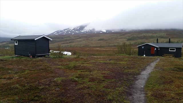
Nonsbu (bildet er ikke tatt fra cachen) ¤ The cabin Nonsbu
Stien til turistforeningshytta Nonsbu tar av fra veien opp Tønsvikdalen like ovenfor cachen Tønsvikdalen #11 - Lingrasmoen. Det vil si, de første 200 meterne følges stikkvei til noen hytter. Herfra til Nonsbu er det rundt fem kilometer, mens det fra parkeringsplassen blir rundt sju kilometer til Nonsbu. På det høyeste midt for Søre Holmevatnet er du oppe i 380 moh., mens det på slutten går 100 meter nedover til Nonsbu på 280 moh.
Denne stien er mye benyttet hele året, og siden 2014 har Nonsbu vært et Ti på topp-mål både sommer og vinter. Den første kneika forbi de to første Nonsbusticachene kan føles litt bratt på ski, men ellers er det en fin tur om vinteren med slakke stigninger. Terrenget på begge sider av stien oppe i høyden er også flott skiterreng når det bare ikke er for dyp snø. Også på sommerføre er det en nydelig tur opp til Nonsbu, og noen våte partier før skoggrensen er godt kloppet slik at du går tørrskodd hele veien.
Du nærmer deg nå Nonsbu med rundt 500 meter igjen til du er framme. Siden det fra før fins to cacher ved Nonsbu, blir dette den siste i trailen fram til Nonsbu - men trailen vil fortsette mot Blåkollkoia.
Cachen er mikro med bare loggark, blyant og FTF-sertifikat.
English:
The trail to the DNT cabin Nonsbu takes off from the road upwards Tønsvikdalen just above the cache Tønsvikdalen #11 - Lingrasmoen. Incidentally, the first 200 meters you follow a side road to some cabins. From here to Nonsbu it is around five kilometers, while it from the parking lot is about seven kilometers to Nonsbu. The highest point 380 m asl is near the lake Søre Holmevatnet, while at the end the trail runs 100 meters down to Nonsbu 280 m asl.
This trail is widely used throughout the year, and since 2014 Nonsbu has been a goal for the "Ti på topp"-hiking both summer and winter. The first climb from before cache Nonsbustien #01 untill #02 can feel a bit steep when skiing, but otherwise it's a nice walk in the winter with ease climbs. The terrain on both sides of the trail up the hill is also great skiing when it just is not too deep snow. Also in summer it's a nice trip to Nonsbu, and passing some wet portions before treeline there are clops so you go on dry ground throughout.
You approach now the cabin Nonsbu with about 500 meters left until arriving. Since there already are two caches at Nonsbu, this will be the last in the trail until Nonsbu - but the trail will continue against Blåkollkoia.
The cache is a micro and contains only logsheet, pencil and FTF Certificate.

Etter siste nullstilling:

Additional Hints
(Decrypt)
[NOR:] Haqre fgrva
[ENG:] Haqre ebpx