Slaktarhaugen Traditional Cache
-
Difficulty:
-

-
Terrain:
-

Size:  (small)
Related Web Page
Please note Use of geocaching.com services is subject to the terms and conditions
in our disclaimer.

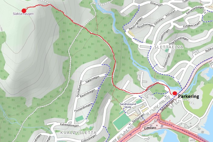
[NOR] Slaktarhaugen er en av fire «Tromsøtopper» i ti på topp, og er ny av året 2016. Toppen ligger 223 meter over havet, og med lange bein og rask gange kan du være oppe på 15‒20 minutter. I følge ti på topp-heftet tar turen 1‒2 timer tur-retur. Det er parkering nederst i Slettabakken (til høyre etter brua og første til venstre; se waypoint). Derfra går det vei/gangvei nesten helt opp til toppen. 150 meter fra toppen går det en tydelig sti fra veien og opp den siste bakken. Cachen er en liten boks som ligger omtrent 100 meter fra toppen. Fra cachen har du fin utsikt til Sandnessundbrua og vestsiden av Tromsøya.
[ENG] Slaktarhaugen is part of a hiking trail initiative where twenty something trails are marked each year with a mailbox with a book at the end where you can write your name. The top is 223 meters above sea level, and if you have long legs and walk fast you can reach the top in 15‒20 minutes. According to the official trail booklet the return trip takes 1‒2 hours. From the parking waypoint you follow a road/dirt road almost to the top. About 150 meters from the top there's a clearly visible trail up the last hill. The cache is a small box hidden about 100 meters from the top. From the cache you have a nice view of the bridge and to the west side of the Tromsø Island.

Additional Hints
(Decrypt)
[NOR] Onx fgrvare [ENG] Oruvaq ebpxf