I’ve always loved the U of A campus and it is one of the most picturesque in Canada. There are lots of beautiful greenspaces, historical buildings with great architecture, interesting sculptures and scenic pathways between the buildings. Situated on the south bank of the North Saskatchewan River, the campus is truly one of the gems that make up Edmonton.
I have visited the campus numerous times over the last 4 decades and there have been significant changes and additions. One of the more recent additions that some of you might not be aware of is the Geoscience Garden. It is located on the north side of the campus along the south side of Saskatchewan Drive and stretches from just east of the Faculty Club to the Tory building.

The Geoscience Garden is an outdoor teaching facility. Most of the rocks have numbered plaques beside them with QR codes on the plaques which can be scanned to see further information about the particular rock. If you don’t have a QR scanner on your smartphone then you can type the link on the plaque into your browser to access the relevant page on the website. The numbers on the plaques correspond to the numbers for the individual rocks listed on the website. You can also visit the website at gg.eas.ualberta.ca (see the link above). It provides general information about the entire Garden and the corresponding geographical regions as well as specific information regarding the different rocks. The first rocks were placed in 2008 and now there are almost 100 rocks of various size and shape.
This earthcache is wheelchair accessible in the summer and is very family friendly. There is metered parking along Saskatchewan Drive but feel free to take public transportation (LRT and/or bus), ride your bicycle or walk. Hopefully you will get a chance to come visit the Geoscience Garden as well as the rest of the campus soon!

The rocks in the Garden are representative of those found in central and western Canada and come from 3 of Canada’s geological regions: the Canadian Shield, the Western Canada Sedimentary Basin, which is part of the Interior Platform, and the Cordillera. The Canadian Shield covers the central and eastern portions of Canada and is made up of some of the oldest rocks on Earth. The rocks vary in age from 1 billion to upwards of 4 billion years old. Located on the eastern side of the Geoscience Garden, the rocks representing the Canadian Shield are mostly igneous and metamorphic. Igneous rock is formed by lava or molten rock cooling and solidifying. Molten rock, or magma, can solidify underground and then be exposed later (granite is a good example of this) or lava can erupt and cool on the Earth’s surface. Metamorphic rocks go through physical and/or chemical change due to extreme heat and pressure. For example, marble can be formed from limestone and slate.
The Western Canada Sedimentary Basin covers most of the prairies including Alberta and the southern portions of Saskatchewan and Manitoba. This area was mostly covered by oceans from around 550 million years ago until the late Devonian period about 360 million years ago.

This inland sea flourished and evidence of invertebrate fossils can often be seen in limestone deposits. Also, the ancient reefs and marine life helped to form the oil and coal deposits found in Alberta. The middle and late Devonian reefs were quite porous and therefore were an ideal rock to hold reservoirs of petroleum. Rocks from the Western Canada Sedimentary Basin can be found in the central portion of the Garden. These rocks are mostly sedimentary which form when sediments transported by rivers, lakes and glaciers deposit in layers and solidify.
Around 200 million years ago, the present day continents started taking shape but it wasn’t until about 130 - 140 million years ago that their shapes began to resemble their current appearance.

It was during this time that the first Cordilleran mountains were formed when the western edge of the Laurasian continent began colliding with the Pacific crust. The land thrust upwards and folded continuously, resulting in the rugged nature of the Cordillera mountain belt which extends from Alaska down into the western United States.

These processes were partly responsible for the coal and petroleum reserves in western Canada. The rocks in the western side of the Garden represent the Cordilleran mountain belt. These rocks are mostly metamorphic and igneous due to the extreme forces involved in forming these mountains.
Around 120 million years ago, during the early Cretaceous period, ancient seas began to flow in from the north and from the south forming the Western Interior Seaway which covered the prairies. For about 50 million years this sea expanded and retreated countless times. Therefore, marine and non-marine Cretaceous sediments can be found in alternating units across the prairies.

To log this Earthcache, e-mail answers to the following questions to the cache owner.
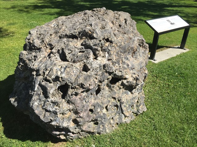
Question 1: The main coordinates for this earthcache take you to 2 signs on either side of a large boulder of Cairn formation.
- What type of rock is this?
- How long ago did it originate and where?
- What is the significance of the large holes in this rock?
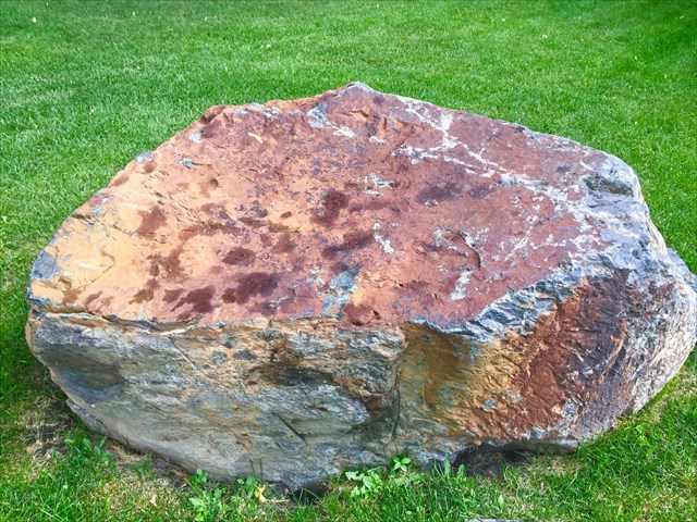
Question 2: At the coordinates for the 2nd stage, there is a large sloping rock.
- What type of rock is this?
- Is it igneous, metamorphic or sedimentary?
- What feature can you see on the surface of the rock that are clues about the environment where it formed?
Question 3: Just to the north-northwest there is a pale grey rock that contains some fossil corals
- What type of rock is this?
- Is it igneous, metamorphic or sedimentary?
- What do you think the fossils tell your about the environment where it formed?
Question 4: At the coordinates for the 3rd stage, there is a tall rock with a mineral that is an unusual colour.
- What type of rock is this?
- Is it igneous, metamorphic or sedimentary?
- What colour is the unusual mineral?
- Suggest what this mineral might be.
Question 5: At the coordinates for the 4th stage, there is another sign with a rock pillar beside it.
- What type of rock is this?
- Is it igneous, metamorphic or sedimentary?
- How many flat sides does it have (not including the top and bottom)?
- Briefly describe the process that created this rock.
Question 6. Optional - feel free to post a picture of you or your GPSr at the site. Please do not include a picture of the interpretive signs though.
Logs will be deleted if an e-mail containing the correct answers isn't received within 1 week. Also, please be respectful of the area when you are visiting. Thanks!! I hope you will enjoy your visit to the Geoscience Garden and also learn something in the process!
Acknowledgements:
The Geoscience Garden was made possible by the University of Alberta Teaching and Learning Enhancement Fund and the Faculty of Science Teaching and Learning Fund, and by the generosity of donors. It was planned and developed by Dr. John Waldron and Dr. Andrew Locock, Department of Earth and Atmospheric Sciences, with the help of many in the university community.
A special thanks goes out to Dr. John Waldron for all of his assistance in making this earth cache a reality!
References:
Waldron, J.W.F., Locock, A.J., Pujadas-Botey, A., 2016. Building an outdoor classroom for field geology: the Geoscience Garden. Journal of Geoscience Education 64, 215–230.
Fensome, Robert A., G. L. Williams, Aicha Achab, J. J. Clague, David Corrigan, J. W. H. Monger, and Godfrey S. Nowlan. Four Billion Years and Counting: Canada's Geological Heritage. Toronto: Canadian Federation of Earth Sciences and Nimbus, 2014. Print.
Miall, Andrew D. "Geological Regions." The Canadian Encyclopedia. 02 July 2006. Web. 28 July 2016.
