
Where are we?
Logging Requirements
TO AUTHENTICATE A LOG FOR THIS EARTH CACHE YOU NEED TO ANSWER SIX QUESTIONS (INDIVIDUALLY AND IN YOUR OWN WORDS IF PART OF A CACHING GROUP) AND EMAIL YOUR ANSWERS VIA THE CACHE GEOCACHING PROFILE.
1. What soil conditions are necessary for a land area to be considered a wetland?
2. Explain the geological situation that caused a seasonal wetland to develop at Blouvlei.
3. The letters Qs and Qc appear on the geological map. What formations do they indicate?
4. Explain the term 'calcrete'.
5. Name two positive things that have been achieved through the incorporation of the Blouvlei wetlands into the Century City development.
6. Just below the boardwalk at GZ are two rows of gabions. (Gabions are wire baskets filled with stones). Describe the differences in terms of colour and shape of the stones in the gabion nearest to the boardwalk and in the gabion nearest to the canal.
7. This is optional, but it would be appreciated if you could upload a photograph of the wetland as seen from the listed co-ordinates.
WHAT IS A WETLAND?
A wetland, as the name suggests, is an area of land that is wet enough for long enough to create soil conditions where air is not present, as water instead of air has filled the pore spaces between the soil particles instead of air. The soil conditions must be saturated or waterlogged for considerable lengths of time. But not all wetlands are the same. Some wetlands are permanently waterlogged while others are only saturated seasonally (ephemeral wetlands). The important thing about all wetlands, though, is that the soil remains sufficiently saturated for anaerobic conditions in the soil to influence the type of plants that will grow there. (Anaerobic = without free oxygen).
 |
 |
| Seasonally Dry |
Seasonally Flooded |
WHAT PART DOES GEOLOGY PLAY?
There are two main ways that an area’s geology may contribute to wetland formation. First, local rock strata (layers) may create an obstruction to horizontal movement of surface or ground water, causing water to accumulate and saturate the surface soil instead of running off. Second, an impermeable rock formation close to the land surface can prevent precipitation (water from rain or snow) from draining vertically down through the soil quickly enough, leading to saturation of the soils for sufficient time for wetland conditions to develop.
LOCAL GEOLOGY
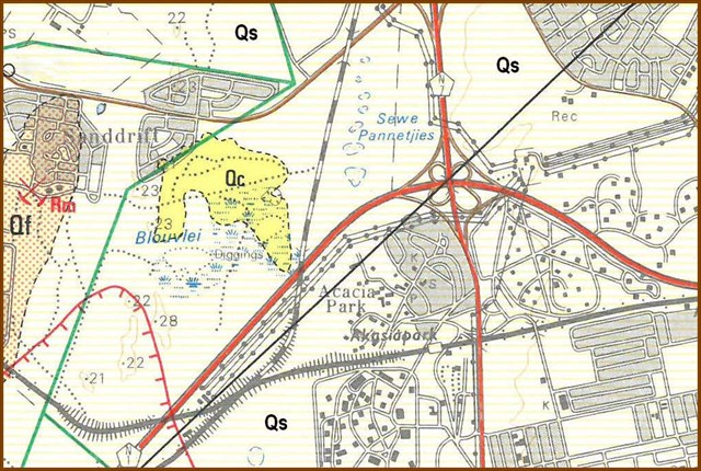 Geological Map of the Area
The geological map shows that the local area is dominated by Quaternary Age transported sandy soils (light yellow horizontal stripe hatching marked Qs). This is the sandy Springfontein formation whose soils are typically free-draining —so wetlands would not develop. But at Blouvlei a patch of Quaternary calcrete (coloured yellow and marked Qc) occurs.
Calcrete is a rock formation formed by the evaporation of calcium–rich water, causing calcium to precipitate out and to cement soil into an impermeable layer. It is this rocky formation, close to the surface, that provides the barrier to downward seepage of rain water and has led to the formation of the Blouvlei ephemeral wetland. In winter the rain water is unable to percolate down through the soil causing wetland conditions; while in summer the hot, dry, windy conditions cause the soil to dry out. The result – a seasonal and ephemeral wetland.
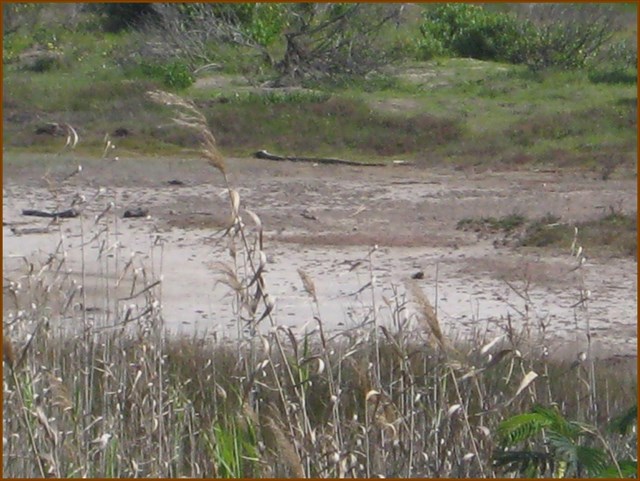
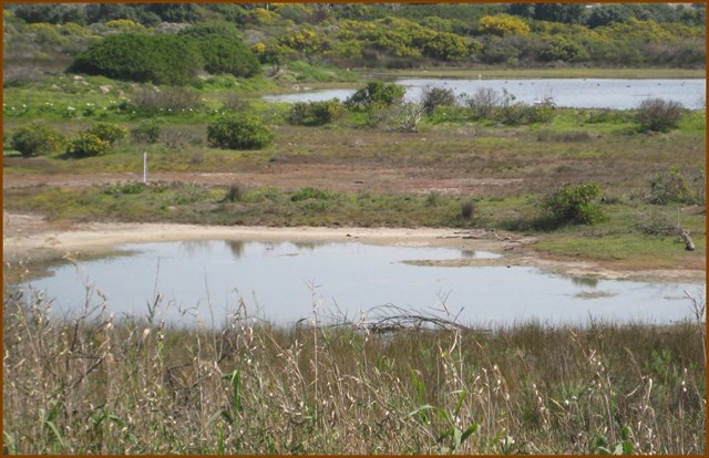
BLOUVLEI
Seasonal vleis were once common close to Cape Town, but they have almost completely disappeared due to (a) urban development, (b) fresh water diluting saline systems, and (c) eutrophication (excessive nutrients). Fortunately, Blouvlei, arguably the last ephemeral pan in the Cape Metropolitan Area, has been incorporated into the Century City complex and preserved as a nature area but also to perform an economically attractive function: keeping water clean.
 Blouvlei
Before the construction of Century City this portion of the Cape Flats was a series of large, shallow ephemeral pans that filled with rain water during the winter and dried out in summer. The Blouvlei Wetland—the ephemeral pan section of the Intaka Island Wetland, preserves one of the last remnants of this rare seasonal habitat.
One of the seasonal pans in the area had become a perennial body of water as a result of its receiving more runoff from surrounding residential areas than was lost by evaporation. This permanent water body became known as Blouvlei. The land surrounding Blouvlei had been invaded by alien plants, especially the Australian Port Jackson Willow Acacia saligna but the rising water levels had resulted in flooding of the Acacia thickets margin. Some of these flooded trees and saplings died, producing a band of dead trees protruding from the water. This arrangement of permanent water, dead and living trees, together with its then undisturbed and inaccessible location made the site an ideal nesting place for water birds.
During the environmental impact assessment investigations, prior to development, Blouvlei was found to be hosting the largest heronry in the greater Cape Town area, and probably one of the largest in the country. In 1995 it had 1845 nests of 12 species. The great majority of the nests were situated in the dead trees standing in the water that was prevented from draining away by the underlying calcrete layer.
CREATION OF A MANAGED WETLAND
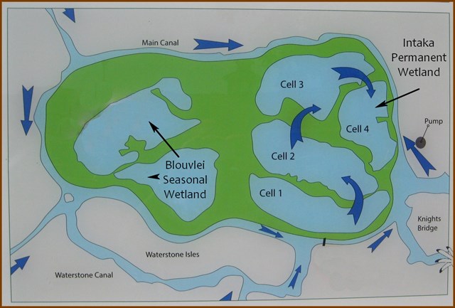
The development of Century City involved the complete destruction of the Blouvlei heronry but did lead to the creation of what is today called the Intaka Island wetland. This is a 16-hectare wetland reserve which is an impotant element of the Century City Development: eight hectares preserve the original Blouvlei ephemeral pans, and the other eight are specially engineered ponds and "cells" designed to store and naturally process the storm and irrigation water from the Century City complex. During wet periods water circulates through the system under gravity but in the dry season the water is pumped from the Century City canal system through these cells of reeds and marshes. These naturally store, polish, and clean the water, improving its quality while also providing a habitat for freshwater life: a win-win situation for both humans and nature. If it were not for the calcrete formation rendering this portion of the sandy Cape Flats impermeable to surface water this entire arrangement would not have been possible.
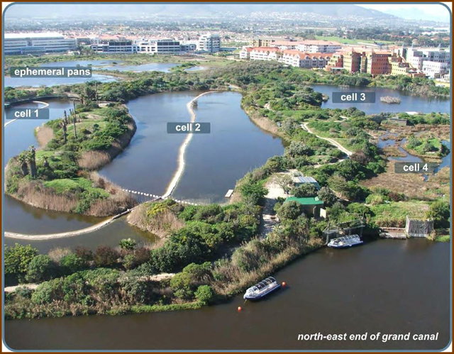 The Managed Wetland Cells
This Earth Cache has shown that through appropriate planning and construction the original geological conditions that caused a seasonal wetland to develop have been used to create both permanent and seasonal wetlands that serve to preserve a rare Cape Flats habitat and also to keep the water of the Century City canal system fresh and clean.
SOURCES
W.R. HARDING. S.M. PEROLD and R.P GLEN: Hepaticae and Zannichelliaceae New Records from an Ephemeral Pan. Blouvlei, In Western Cape, South Africa
J.A. Harrison & M. Maciver: The Constructed Heronry at Blouvlei, Century City, Cape Town.
SOUTH AFRICA, January 2001, Take a walk on the canal side. [http://www.iol.co.za/travel/south-africa/take-a-walk-on-the-canal-side-880873]
1:50 000 Geological Series 3318 DC Bellville (1984)