Toponaut: Fountainhead
To find this cache, you must first retrieve the clue from the Toponaut: Fountainhead 1, Piles of Rocks cache.
Inside this cache, you you will find a clue needed to search for Toponaut: Fountainhead 3, Relics.
This series needs to be done in sequence, both geographically, in order of difficulty, and to retrieve clues to continue. Detailed instructions will be included for the first cache, and then decrementally so as the series progresses. All together the series will lead to about a 6 mile round trip hike (or possibly more of course!).
Please see the first cache in the series for preamble and important information on what you'll need.
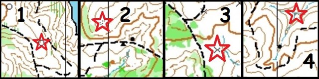
Navigate to the red star. From there, use the projection information found inside Piles of Rocks to locate the Stage 1 container. The Stage 1 container has a map with a second target and projection. Navigate and project similarly to find the cache. (See note below on accessing the container.)

Primer (intended directions with map reading tips along the way)
- Find the eastern part of the blue equestrian trail and head north, towards the main east-west trail that runs just south of the target location.
- On your way there will be some intermittent creeks to step over (dashed blue line) and one main stream to cross (solid blue line).
- The target is at a summit (closed brown contour line).
- The summit is an area of protruding rocks/stony ground (small black dots). Stand on the highest one to do your projection.
- Note: As you proceed towards the Stage 1 container, note the large rock to the north of the trail (filled black circle).
- Just to be clear: there is nothing hidden at either of the red star locations. They are just where you do your projections from.
- This cache has two stages. The container at Stage 1 will have a map with a new target location to navigate to, denoted with a red star. It will also have a new projection. Navigate to the new red star and do your projection from there to find Stage 2, the final.
- As you use your GPS to navigate to the cache, pay attention to where you are on the map! This will be helpful/crucial in continuing to the next cache in the series.
Some other notes:
- I have set the "not winter friendly" attribute solely due to difficulties with finding the piles of rocks in the snow.
- As you navigate, it might be prudent to come up with a point that is "too far". For example in the first cache, using the trail system as a guide.
- Within the cache you will find a distance and bearing needed for the next cache in the series. Record this but don't take it with you.
- Have fun on your endeavor! However this is wild territory so be mindful of copperheads, bees, and other beastly beasts.
Links to caches:
 No night caching


Best Series 2016