Fossil supervolcano EarthCache
varaless: L'alluvione del Sesia ha spazzato via i cartelloni e reso irraggiungibili alcuni WP.
Sono costretto ad archiviare.
Grazie a chi ha visitato il supervulcano!
varaless 🇮🇹
Geocaching: My profile
project-gc: Stats
Twitter: @varalessIT
-
Difficulty:
-

-
Terrain:
-

Size:  (other)
Please note Use of geocaching.com services is subject to the terms and conditions
in our disclaimer.
[ITA] Per chi ama gli EarthCache
[ENG] For those who love EarthCache
[ITA]
Questo earthcache vi porterà a visitare quattro siti del Supervulcano del Sesia. In ogni sito troverete un cartello illustrativo con alcune spiegazioni.
***Definizione***
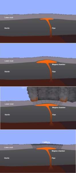
Un supervulcano è un qualsiasi vulcano in grado di produrre una eruzione vulcanica con una massa di materiale espulso di diverse centinaua di km cubi. I supervulcani si formano quando il magma del mantello si insinua nella crosta terrestre, ma non riuscendo a romperla accumula una grande e crescente quantità di magma finché la crosta è in grado di contenere la pressione.
***Il Supervulcano fossile***
Tra la Valsesia e la Valsessera è stato scoperto un supervulcano fossile unico nel suo genere. Le ricerche sono state condotte dal Prof. Silvano Sinigoi (Università di Trieste) e dal Prof. James Quick (Southern Methodist University, Dallas).
Nella bassa Valsesia vi sono affioramenti di rocce vulcaniche e nella zona di Balmuccia emergono strati molto profondi della Terra (peridotiti di mantello). E' stato dimostrato che le rocce magmatiche intruse in questa sezione crostale e le rocce vulcaniche affioranti tra Borgosesia e la pianura Padana appartengono ad un unico sistema magmatico attivo tra 290 e 280 milioni di anni fa e ormai fossile. Circa 60 milioni di anni fa, in seguito all’apertura dell’oceano Atlantico e la conseguente deriva del continente Africano, la collisione tra Africa ed Europa ha portato alla formazione delle Alpi e, in corrispondenza della Valsesia, ha ripiegato di 90° la sezione crostale, mettendo in luce le parti più profonde del sistema di alimentazione del vulcano. Grazie a questo rovesciamento della crosta terrestre è possibile oggi osservare direttamente ciò che in origine si trovava a 25 chilometri di profondità. Si tratta di una struttura geologica ormai fossile, che espone parti tra le più nascoste e profonde del sistema magmatico sottostante il vulcano, in genere inaccessibili.
***L'attività del supervulcano del Sesia***
Attorno a 290 milioni di anni fa buona parte dell’Europa è stata interessata da una anomalia geotermica che ha causato la fusione parziale del mantello superiore. Il magma prodotto dalla fusione è risalito fino alla parte più profonda della crosta. Successive intrusioni di magma proveniente dal mantello hanno progressivamente causato la formazione di un grande complesso magmatico di composizione basica (chiamato Complesso Basico) nella crosta di ciò che attualmente è la Valsesia. Il magma basico interagiva con la crosta, incorporando ed assimilando successivamente livelli crostali sempre più alti. Contemporaneamente parte delle rocce della crosta fondeva per il calore trasmesso dal magma basico, che stava raffreddando e iniziava a cristallizzare. Dalla parziale fusione della crosta ebbero origine fusi di composizione granitica, che migravano verso l’alto e che per circa 10 milioni di anni alimentarono l’accrescimento di plutoni nella porzione meno profonda della crosta o furono effusi, determinando l’attività vulcanica.
Dalla mescolanza dei magmi di origine mantellica con quelli derivati dalla fusione della crosta si sono formati magmi "ibridi", dai quali sono cristallizzate le rocce che costituiscono la maggioranza del Complesso Basico. A loro volta, i fusi acidi derivanti dalla crosta che hanno alimentato i corpi granitici furono contaminati dal materiale proveniente dal mantello.
Tra 290 e 280 milioni di anni fa, nella zona più profonda della crosta, il magma basico raffreddava formando un "mush" cristallino, costituito in parte da cristalli e in parte da fuso interstiziale. Al di sopra del Complesso Basico il materiale crostale stava in parte ancora fondendo, mentre più in alto anche i plutoni acidi raffreddavano originando un mush cristallino. Contemporaneamente in superficie aveva luogo l’attività effusiva.
Poco tempo dopo, attorno a 280 milioni di anni fa, ebbe luogo una violentissima eruzione accompagnata dal collasso del sistema, con la formazione di una gigantesca caldera. Nel giro di pochi giorni il tetto della camera magmatica crollò e vennero emesse centinaia di chilometri cubi di materiale piroclastico: uno dei più violenti eventi geologici conosciuti.
L’intrusione di materiale del mantello che portò alla formazione del Complesso Basico fu dunque il “motore termico” che determinò la formazione su larga scala di magmi acidi, per fusione parziale della crosta. Furono questi ultimi a originare plutoni e una cospicua attività vulcanica in tutta la zona, fino all'eruzione finale.
***Il geoparco "Supervulcano del Sesia"***
Il Supervolcano del Sesia è uno dei più importanti e impressionanti componenti del sistema magnatico del Sesia. E' una vasta caldera riolitica con un diametro superiore ai 15 km, attualmente in parte ricoperta da depositi sedimentari più recenti della pianura padana. Si stima che il volume del materiale eruttato superasse i 300 km cubi, facendo dell'evento che ha formato la caldera una cosidetta "super eruzione".
Il Supervulcano del Sesia si estendeva su una zona che oggi comprende, oltre la Valsesia e la Valsessera, anche parte del Biellese occidentale fino a toccare il lago Maggiore. Amministrativamente si trova nelle province di Biella, Vercelli e Novara.
L'area del Supervulcano fa parte del "Sesia Val Grande Geopark" riconosciuto dall'UNESCO il 5 settembre 2013 ed inserito nel programma "UNESCO Global Geoparks" nel 2015.
***Per loggare l'EarthCache***
Per loggare l'EarthCache dovete visitare i quattro waypoint (tre sono raggiungibili in auto con parcheggio comodo, l'ultimo richiede una passeggiata di circa 500 metri partendo dal WP3) e inviarmi, via email o con messaggio tramite il sito geocaching.com, le risposte alle domande seguenti. Vi prego di notare gli attributi D/T. La difficoltà è elevata perché il cache richiede di visitare diversi luoghi piuttosto distanti tra loro. Inoltre, vi prego di inviarmi risposte molto chiare (alcune informazioni si trovano anche su internet, ma non sono precise quanto una visita sul campo). Il valore di terreno è medio perché al WP2 occorre percorrere una breve discesa (al ritorno salita) piuttosto ripida e sdrucciolevole. Vi prego inoltre di fare attenzione quando camminate sulle rocce in prossimità del fiume.
Vi consiglio di visitare i quattro punti nell'ordine proposto per due motivi: 1) è l'ordine dei cartelli illustrativi del geoparco, 2) i parcheggi sono più agevoli e non occorre attraversare la strada a piedi.
WP1 - Dinelli
Coordinate: N45 48.355 E008 07.547 (listing)
Domanda 1.1: Quando ha eruttato il supervulcano? (leggi il cartello)
Domanda 1.2: Sali sul ponte e guarda a monte (controcorrente). Che differenza noti nelle rocce del fiume alla tua destra e alla tua sinistra? Quali sono più levigate?
WP2 - Balmuccia
Coordinate: N45 49.193 E008 09.166
Domanda 2.1: Quanti anni fa la peridotite è stata inclusa nella crosta? (leggi il cartello)
Domanda 2.2: Quale opera dell'uomo si vede ripetuta molte volte nelle rocce?
WP3 - Isola di Vocca (1)
Coordinate: N45 49.603 E008 10.258
Domanda 3: Cosa sono le rocce grigie? (leggi il cartello)
WP4 - Isola di Vocca (2)
Coordinate: N45 49.515 E008 09.944
Domanda 4.1: Che temperatura avevano i fusi che hanno generato le rocce? (leggi il cartello)
Domanda 4.2: Sugli affioramenti rocciosi l'uomo ha costruito qualcosa. Che cosa?
[ENG]
This EarthCache will take you to visit four sites of the Supervulcano del Sesia. At each site you will find an illustrative sign with explanations in english.
***Definition***
A supervolcano is any volcano capable of producing a volcanic eruption with an ejected mass of several hundreds cubic kilometers. Supervolcanoes occur when magma in the mantle rises into the crust but is unable to break through the crust, and pressure builds in a large and growing magma pool until the crust is unable to contain the pressure.
***The fossil Supervolcano***
A single fossil supervolcano has been discovered between Valsesia and Valsessera. The researches were conducted by Prof. Silvano Sinigoi (University of Trieste) and Prof. James Quick (Southern Methodist University, Dallas).
In the low Valsesia there are outcrops of volcanic rocks and in the area Balmuccia very deep layers of the Earth (mantle peridotites) emerge. The igneous rocks intruded in the crust and outcropping volcanic rocks between Borgosesia and the Po valley belong to a single magmatic system active between 290 and 280 million years ago and now fossilized.
About 60 million years ago, following the opening of the Atlantic Ocean and the consequent drift of the African continent, the collision between Africa and Europe has led to the formation of the Alps, and, at the Valsesia, the crustal section tilted by 90°, highlighting the deepest parts of the volcano system. Thanks to this reversal of the Earth's crust you can directly observe what originally was 25 kilometers deep. It is a geological structure fossilized, which exposes parts of the most hidden and deep the magma below the volcano system, generally inaccessible.
***The activity of the Supervolcano***
Around 290 million years ago a large part of Europe was subjected to a geothermal anomaly that partially melted the upper mantle. The magma produced by the fusion climbed to the deeper part of the crust. Successive intrusion of magma from the mantle have gradually caused the formation of a large complex of magmatic basaltic composition (so-called Mafic Complex) in the crustal on what is currently the Valsesia. The basaltic magma interacted with crust, incorporating and assimilating successively higher and higher crustal levels. At the same time part of the crustal rocks melted by the heat transmitted from the basaltic magma, which was cooling and beginning to crystallize. The partial melting of the crust produced granitic molten migrating upwards and for about 10 million years fueled the growth of plutons in the shallow portion of the crust or they were poured, causing volcanic activity.
By mixing of magmas of mantle origin with those derived from the fusion of crust, "hybrid" magmas are formed, from which they crystallized the rocks that make up the majority of the Mafic Complex. In turn, the acid spindles resulting from the crust that they have fueled the granitic bodies were contaminated by material from the mantle.
Between 290 and 280 million years ago, in the deepest area of the crust, the alkaline magma cooled down forming a "mush" of crystals consisting solid crystals in the interstitial zone. Above the Mafic Complex the crustal material was in part even blending, while higher even acidic plutons cooled down originating a crystalline mush. At the same time, on the surface effusive activity took place.
A short time later, around 280 million years ago, a violent eruption took place accompanied by the collapse of the system, with the formation of a caldera of at least 13 km in diameter. Within a few days the roof of the magma chamber collapsed and hundreds of cubic kilometers of pyroclastic material were ejected: one of the most violent geological events on the Earth.
The intrusion of mantle material that led to the formation of the Mafic Complex was thus the "engine" which determined the large-scale formation of acidic magmas, for partial melting of the crust. The latter were to originate plutoni and a conspicuous volcanic activity throughout the area, until the final super-eruption.
***The geopark "Supervolcano Sesia"***
The Sesia Supervolcano is one of the most significant and impressive components of the Sesia magmatic system. Partially covered by younger sedimentary deposits of the Po plain, it is a huge rhyolitic caldera with a diameter exceeding 15 km. The estimated volume of ignimbrite erupted exceeded 300 cubic km, making the caldera-forming event a "super eruption".
The Supervolcano Sesia extended over an area that now includes, in addition Valsesia and Valsessera, also part of the Biellese and Maggiore lake. Administratively it located in the provinces of Biella, Vercelli and Novara.
The area of the Supervolcano is part of the "Sesia Val Grande Geopark" by UNESCO September 5, 2013 and entered in the "UNESCO Global Geoparks" programme in 2015.
***To log the EarthCache***
To log the EarthCache you have to visit the four waypoints (three are accessible by car with parking available, the last requires a walk of about 500 meters from WP3) and send me, via email or message by geocaching.com, the answers to the following questions. Please note the D/T attributes. The difficulty is high because to log the cache you need to visit several places rather far apart each other. Please send me very clear answers (some information is available on-line, but they are not as precise as a real visit). Allowed languages for answere are italian and english. The terrain value is medium because of WP2 requires a walk quite steep and slippery. Additionally, please pay attention when you are walking on the rocks close to the river.
I recommend you visit the four points in the proposed order for two reasons: 1) it is the order of the information signs proposed by the geopark, 2) parking is easier and you don't have to cross the road.
WP1 - Dinelli
Coordinate: N45 48.355 E008 07.547 (listing)
Question 1.1: How many years ago the supervulcano erupted? (read the information sign)
Question 1.2: Walk on the bridge and watch upstream. What is the difference of the rocks at your left compared to those on your right? What are the smootest?
WP2 - Balmuccia
Coordinate: N45 49.193 E008 09.166
Question 2.1: How many years ago the peridotite was injected into the crust? (read the information sign)
Question 2.2: Man have do something on the rocks many times. What?
WP3 - Isola di Vocca (1)
Coordinate: N45 49.603 E008 10.258
Question 3: What are gray rocks? (read the information sign)
WP4 - Isola di Vocca (2)
Coordinate: N45 49.515 E008 09.944
Question 4.1: What was the temperature of the basaltic melt? (read the information sign)
Question 4.2: Men have build something on the rocks. What?

Additional Hints
(Decrypt)
[ITA] qviregvgv [ENG] rawbl vg
Treasures
You'll collect a digital Treasure from one of these collections when you find and log this geocache:

Loading Treasures