화진포호는 한국에서 가장 큰 석호로 화진포해변 부근의 사취 발달로 만의 입구가 막히며 형성되었다. 화진포 주변 지역의 기반암은 선캄브리아기의 경기편마암복합체와 이를 관입한 쥐라기 대보화강암, 그리고 백악기의 불국사화강암, 제4기의 충적층으로 구성되어 있다.
Hwajinpo lake is the largest lagoon in Korea. A bar formed as a spit grew across a bay joining up two headlands. The old bay became a lagoon seperated from the sea. The basement rock around the lake is comprised of Gyeonggi gneiss composite of Precambrian age, Daebo granite which intruded Gyeonggi gneiss, Bulguksa granite in Cretaceous period and the alluvial layer of Quaternary period.
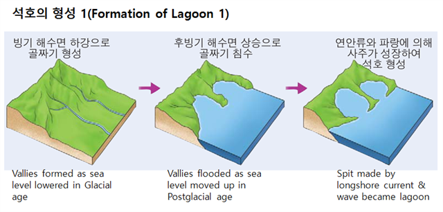
현재로부터 약 18,000년 전쯤 최종빙기가 끝날 때 해수면은 현재보다 120~140m 정도 낮았었다.
그리고 대략 10,000년 전쯤부터 해수면이 급격히 상승하기 시작하여 6,000년 전쯤 현재의 해안선이 만들어졌다. 이때 해안이 침수되는 과정에서 산지 말단부의 골짜기 깊은 곳까지 해수가 침투하여 좁은 만을 형성한다.
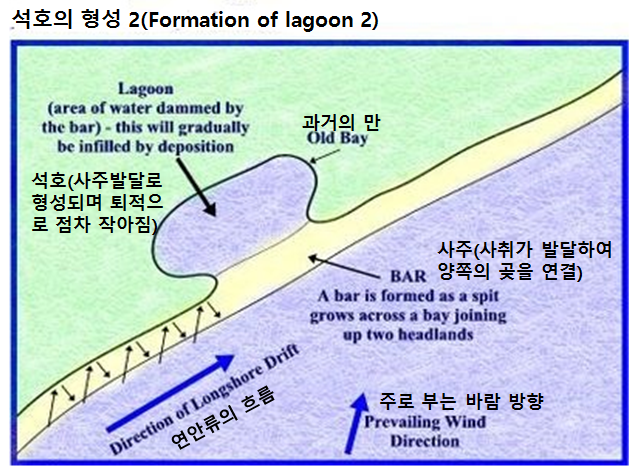
그 후 배후산지에서 하천으로 공급된 모래 퇴적물이 연안 조류와 파랑 작용으로 사주를 만들게 되고, 사주가 성장하여 만의 입구를 가로 막아 바다와 격리된 석호가 형성되었다. 그 시기는 대략 3,000년 전쯤으로 알려져 있다.
When the final Glacial age ended about 18,000 years ago, sea level was 120~140m lower than the present.
The sea level moved up rapidly about 10,000 years ago. The current coastline was made about 6,000 years ago. At that time the coastline was flooded and the narrow bays are formed.
Later sand sediments flowing from the mountain area made a spit with longshore current and wave. The spit formed a bar, that grew across a bay joining up two headlands. And finally the lagoon was formed and seperated from the sea. It was about 3,000 years ago.
화진포호는 하천에서 공급되는 토사로 인해 지속적으로 호수 내부가 채워지면서 늪지나 충적지로 변하여 언젠가는 사라질 것이다. 이러한 이유로 석호는 동해안의 해안선을 단조롭게 만드는 요인이 되기도 한다.
Hwajinpo lake will gradually be infilled by deposition of sediments from the neighboring streams and become a swamp or alluvion some time or other. And it will disappear in the end. Thus the lagoons are one of the reasons that make the eastern coastline simple.
화진포호는 바다와 연결되어 있어 담수와 해수가 만나는 독특한 생태계를 이루고 있다. 특히, 해일과 강한 파도로 바닷물이 호수로 유입되는 갯터짐 현상이 종종 발생하여 담수와 해수 사이의 유기물을 주기적으로 교환해주고 있다. 갯터짐 현상이 일어나면 해수와 담수가 섞여 염분농도 0.5ppt 이상인 혼합수를 만드는데 이러한 물을 기수(brackish water)라고 하며, 이렇게 기수가 포함된 호수를 기수호라고 한다. 기수호에는 담수생물과 해양생물이 공존하는 독특한 생태계가 나타나 다양한 생물들이 서식하고 있다.
Hwajinpo Lake is connected to the sea making very unique ecosystem where fresh water and seawater meets. When a tsunami or big waves occurs seawater gets into a lake making two waters exchange organic matters. When seawater and fresh water are mixed making salt concentration higher than 0.5 ppt we call that water brackish water. In brackish water lake limnobios and sea creatures living together.
[로그하는 방법]
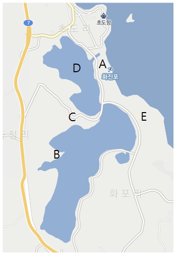
- 사진은 호수 주변의 지도입니다. 호수주변의 자연환경을 자세히 관찰하시고, 아래 내용중 맞지않는 것은 무엇인가요? (1) A는 해안 사취인데, 이것이 성장해서 사주와 해안사빈을 만들고 해안을 단조롭게 하였다. (2) B와 C부분의 하천이 이 석호에 퇴적 물질을 쌓아 놓으면서 점점 호수 면적이 줄어들게 된다. (3) D는 원래 만이었는데, 연안 사주가 성장하면서 석호가 되었다. (4) E는 하천에서 나온 모래나 돌출된 해안이 침식되면서 나온 모래들이 연안류와 파랑의 퇴적작용으로 쌓인 것이다.
- Waypoint에 가시면 큰 바위가 있습니다. 이 바위는 규암입니다. 다음은 규암에 대한 설명입니다.(1) Waypoint에서 본 이 바위의 색은 무엇입니까? (2) 이 바위의 높이는 얼마입니까? <사암 중에서 석영의 비율이 높은 석영사암이 높은 열과 압력을 받아 생성된 변성암이다. 색은 흰색에서 회색이 일반적이나 산화철(Fe2O3) 및 다른 불순물이 함유되어 분홍색, 갈색, 검은색을 띌 때도 있다. >
- 캐시존에서 화진포호를 배경으로 당신 또는 당신의 GPS를 찍은 사진을 로그에 올려주세요. (선택사항이지만 사진을 올려주시기를 부탁드립니다.)
- 답을 제 Profile에 있는 메시지창을 이용해 제게 보내주세요. 이제 로그하셔도 됩니다. 답에 문제가 있을 경우 제가 메시지를 드리겠습니다.
 [How to log]
- The picture is the map around the lake. Pleast observe the environment around the lake very carefully and choose the incorrect explanation! (1) A area is a spit. It grew and made a lagoon and sand beach making coastline simple. (2) There are streams near B and C area. They deposit the sediments in the lagoon making the lake smaller. (3) D area was originally a bay but later became a lagoon as the bar grew. (4) E area was made by sedimentation of sand from the stream as a result of longshore current and wave.
- When you go to Waypoint you will see a big rock. This rock is a quartzite. The following sentences are the explanation of this rock. (1) What is the color of this rock when you see it from Waypoint? (2) How tall is this rock?
<Quartzite is a hard, non-foliated metamorphic rock which was originally pure quartz sandstone. Sandstone is converted into quartzite through heating and pressure usually related to tectonic compression within orogenic belts. Pure quartzite is usually white to grey, though quartzite often occur in various shades of pink and red due to varying amounts of iron oxide (Fe2O3). Other colors, such as yellow, green, blue and orange, are due to other mineral impurities.>
- Upload the photo of you or your GPS with the lake in the background at the cache zone! (The task is optional but I would highly appreciate if you would do so.)
- Please send the answers to me by message on my profile! You may log as 'Found'. If the answer is not correct, I will contact you.
(Reference)
study.zum.com
www.slideshare.net
| I have earned GSA's highest level: |
 |