A retooled cache in downtown Bridgeport. Once again it visits one of the city's historic sites. It's easy terrain and good for cachers of all ages. You can reach the final by street if you are driving or by sidewalk if you are walking. It shouldn't be done at night. Please stay away from the building. Although poison plants is listed as one of the attributes it can be completed easily without getting into it, if you know what poison ivy looks like.
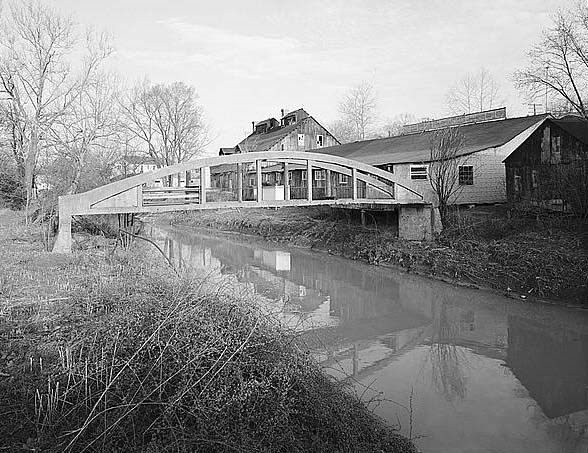
The Bridgeport Lamp Chimney Company was founded in 1904 in Bridgeport. At it’s peak, it produced 24,000 chimneys a day and employed 174 people. The concrete bowstring bridge was built to move the chimneys on handcarts from the plant to it’s warehouse on the other side of Simpson Creek. The Master Glass Company, a marble factory, purchased the plant and moved to Bridgeport in 1941 and in 1950 took over the assets of the Akro-Agate Marble Company of Clarksburg. The company manufactured glass balls for industrial use, colored signal lenses, toy marbles, glass ball reflectors used in highway signs and guard rail posts, and other products for various industrial uses. The company ceased operations in 1973, and the City of Bridgeport bought the property. The building has been torn down, and the former site of the tannery, lamp chimney factory, and marble factory is now a parking lot for the Benedum Civic Center. The bridge is the only thing that survived and has been restored and placed on the National Register of Historic Places.
The posted coordinates will take you to a plaque next to the bridge. You will need to find the year the bridge was built, the year the bridge was restored and the year the bridge was placed on the National Register of Historic Places. To find the final coordinates:
A = the year it was restored minus the year it was added to the National Register of Historic Places minus 1
B = the last two digits of the year it was built divided by the number of dates on the plaque, plus 1
CD = Subtract 2 from the last two digits of the year it was built
The final coordiates will be: N 39 17.4AB W 080 16.1CD
Please be sensitive to the people who may be nearby when you arrive at the final.