Deutsch
Kurzbeschreibung
Es freut uns natürlich, dass sie auch diese Reise wieder über unser Reisebüro gebucht haben.
Als Geocacher bewegen wir uns ständig in allen drei Dimensionen, nach Osten, Westen, nach oben und nach unten. Darum wollen wir auf der heutigen Reise noch die 4. Dimension dazunehmen: die Zeit. Wir begeben uns aus der Gegenwart zurück in die Vergangenheit in zwei verschiedene Jahre um am Schluss wieder in der Gegenwart zu landen.
Auf geht's !
Reisevorbereitungen
Folgendes ist für die virtuelle Zeitreise einzupacken:
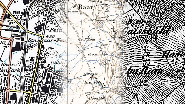
- 1:25’000 Kartenmaterial von Baar und der weiteren Umgebung (z.B. Zeitreisekarte Ausgabe 2012)
- Dufourkarte Erstausgabe (1864)
Achtung: Zeitreisenkarten aus dem selben Jahr funktionieren nicht, mit denen verläuft man sich !
- Siegfriedkarte Erstausgabe (1926)
Achtung: Zeitreisenkarten aus dem Jahr 1926 funktionieren nicht, mit denen verläuft man sich !
- Für die Feldarbeit: Smartphone mit den gängigen Hilfsmitteln für's Cachen (QR-Code, Entschlüsselungs-Hilfsmittel)
Vorgeschichte
Wir begeben uns zum Startpunkt (Station 1) der virtuellen Zeitreise, der Kirche Sankt Martin in Baar. Dort betrachten wir die schmucke Kirche aus dem 14. Jahrhundert. Ebenso schauen wir uns die nähere Umgebung an und vergleichen das mit den verschiedenen mitgebrachten Karten.
Müde von all den spannenden Eindrücken setzen wir uns kurz auf eine Mauer… und schlafen ein.
Als wir wieder aufwachen sieht alles komplett anders aus, die Autos sind weg, die Umgebung ist wie ausgewechselt. Nur die Kirche erkennen wir wieder. Was ist hier los ?
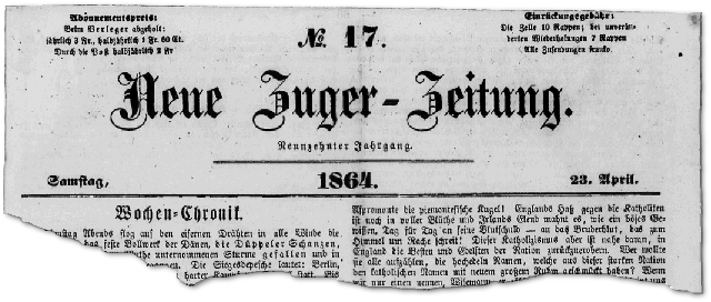
Zurück im Jahre 1864
Langsam dämmert es uns, irgendwie wurden wir in die Vergangenheit katapultiert, genauer gesagt ins Jahr 1864.
Alles sieht genau so aus wie auf der mitgebrachten Dufourkarte aus dem Jahre 1864 (Wichtig: wir brauchen die Erstausgabe, sonst könnten wir uns eventuell verlaufen!).
Ein Stück einer Zeitung, das uns der Wind ins Gesicht bläst, trägt das Datum des 23. April 1864.
Ein Passant, den wir fragen, bestätigt uns das auch noch. Er schaut uns aber an als wenn wir vom Mond kämen, schon etwas unverständlich und unhöflich, oder nicht ?
Wenn wir schon mal hier (im Jahr 1864) sind, dann wollen wir uns natürlich auch ein klein wenig umsehen. Auf der Dufourkarte sehen wir, dass vom ‘Kreisel’ um die Kirche (wie man heute sagen würde) mehrere Strassen und ein Weg weggehen. Nachdem wir die Anzahl der Strassen notiert haben (A = Anzahl Strassen, beim Kirchenkreisel, ungerade Zahl), entscheiden wir uns für die Strasse in Richtung Süden, der Stadt Zug entgegen.
Auf der Karte entdecken wir eine spannende Ortsangabe, es ist die einzige Ortsangabe, die auf der direkten Strasse zwischen Baar und Zug über die Strasse geschrieben ist. Die schreiben wir uns auch auf (B = Buchstabenwert der zweiteiligen Ortsangabe, so wie auf der Karte geschrieben).
Es ist eindrücklich wie klein und übersichtlich Zug im Jahr 1864 noch ist. Nicht, dass es heute riesig ist, aber damals war es doch noch einiges kleiner. Interessant ist auch wie die Katastrophenbucht vor der Katastrophe aussieht. Nach dem kurzen Rundgang durch das Städtchen schauen wir auf die Karte und entscheiden uns mal mit dem Zug weiterzufahren. Wir gehen also zum Bahnhof warten auf den Zug. Leider fahren die noch nicht im Halbstundentakt, aber wir haben Glück, der Zug kommt bald.
Wir steigen an der zweiten Station wieder aus (Information: auf der Erstausgabe der Dufourkarte gibt’s dazu nur eine Möglichkeit, da es nur eine Bahnlinie gibt). Es fällt uns auf, dass die damalige Schreibweise unseres Aussteigeortes einen Buchstaben mehr enthält als die heutige, diese interessante Tatsache notieren wir auf unseren Zetteln (C = Buchstabenwert des ‘überzähligen’ Buchstabens in der damaligen Schreibweise).
Die paar wenigen Häuser um den Bahnhof haben wir bald mal gesehen. Nach einem Blick auf die Dufourkarte wissen wir, wohin wir nun wollen: wir gehen vom Bahnhof, wo wir ausgestiegen sind, ungefähr 1.4 km westwärts, bis wir an einen grösseren Fluss kommen. Diesem Fluss folgen wir in flussabwärts bis zur nächsten auf der Dufourkarte eingezeichneten Brücke. Den Namen dieser Brücke schreiben wir auf, vielleicht brauchen wir den ja noch (D = Anzahl Buchstaben des Namens der Brücke, so wie auf der Karte geschrieben).
Der Strasse, die hier über diese Brücke führt, folgen wir in Richtung Nordosten. In einem grösseren Bogen kommen wir zu einem kleineren Fluss, welcher ganz in der Nähe aus einem See mündet. In dem Dörfchen, in dem dieser Fluss aus dem See mündet steht wieder eine Kirche. Dorthin gehen wir. Damit wir uns in Raum und Zeit nicht komplett verlieren, schreiben wir den Ort, in dem wir nun sind, wieder auf (E = Buchstabenwert des Ortes).
Diese Rundreise im Jahr 1864 und all die interessanten aber aufwühlenden Erlebnisse machen müde. Vieles bewältigten wir ja zu Fuss, der öffentliche Verkehr ist definitiv noch nicht so gut ausgebaut wie heute.
Wir müssen uns mal kurz hinsetzen… und schlafen wieder ein.
Vorwärts ins Jahr 1926
Nachdem wir aufgewacht sind und schon wieder alles anders aussieht, fragen wir uns nicht lange, was passiert ist. Wir überlegen, in welcher Zeit wir wohl dieses mal gelandet sind.
Auf der Mauer, auf der wir eingeschlafen sind, finden wir ein Stück Zeitung datiert auf den 15. Juli 1926.
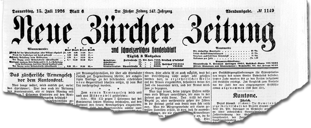
Ein Passant (auch der schaut uns doch recht merkwürdig an) teilt uns mit, es wäre das Jahr 1926. Da wird uns nun wohl für die weitere Rundreise die mitgebrachte Erstausgabe der Siegfriedkarte aus dem Jahre 1926 helfen können (auch hier wichtig: wir brauchen wieder die Erstausgabe, sonst könnten wir uns eventuell verlaufen!). Also los, lasst und die Umgebung im Jahr 1926 erkunden.
Wir folgen dem kleinen Fluss, der in diesem Dorf aus dem See mündet, wieder flussabwärts. Es geht vorbei an einer ersten Fabrik. Vor einer zweiten Fabrik teilt sich der Fluss für ungefähr 1.3 Kilometer in zwei Teile. Nach der Fabrik vereinen sich die zwei Teile wieder. Danach geht’s weiter durch Sumpfgebiet und dort teilt sich der Fluss für ungefähr 800 Meter wieder in zwei Teile. Zwischen diesen zwei Flussteilen steht ein Kloster (Achtung: auf der Siegriedkarte ist der Ort nicht als Kloster angeschrieben, auf der heutigen und der ganz alten Dufourkarte aber schon). Für das Kloster und den dazugehörigen Weiler existieren zwei verschiedene Schreibweisen, je nach Karten (F = Wieviele Buchstaben hat der Name des Klosters auf der Siegfriedkarte, Erstausgabe).
Gleich nach dem Kloster fliessen die zwei Flussteile wieder zusammen und eine Brücke führt über den wiedervereinten Fluss. Dort steht auf der Siegfriedkarte eine Höhenangabe. Die notieren wir uns (G = Höhenangabe bei Brücke nach Kloster).
Von dort aus wandern wird dem Flüsschen entlang weiter, bis wir zur Kantonsgrenze kommen. Die Kantonsgrenze führt mehr oder weniger nach Osten einem kleinen Bach entlang. Diesen Namen schreiben wir natürlich auch auf (H = Anzahl Buchstaben Namen des Bachs auf Siegfriedkarte, so wie auf der Karte geschrieben). Ebenso notieren wir die angegebene Höhe der Stelle, wo der Grenzbach in den kleinen Fluss mündet, dem wir gefolgt sind, und die Kantonsgrenze eine rechten Winkel bildet (I = Höhenangabe bei Mündung des Baches).
Nun folgen wir der Kantonsgrenze zuerst in Richtung Osten, dann Südosten, durch Wälder, über Strassen bis zum Punkt 481. Dort stehen gemäss der Erstausgabe der Siegfriedkarte 2 Häuser und der Weiler hat einen Namen, den wir natürlich wieder aufschreiben (J = Buchstabenwert des Ortes bei Punkt 481). Achtung, andere Karten aus dem selben Jahr könnten uns in die Irre führen.
Von dort folgen wir dem kleinen Weg mehr oder weniger in Richtung Süden, bis zum nächsten Dorf mit einer Kirche. Dort machen wir nach dem langen Fussmarsch eine kurze Pause und schreiben den Namen des Ortes auf, in dem wir uns befinden (K = Buchstabenwert des Ortes).
Nach dem kurzen Halt folgen wir von der Kirche aus der Strasse ungefähr 1.4 km südwärts (südöstlich) bis zur Brücke bei Punkt 428. Wenn wir uns recht erinnern, fliesst dieser Fluss heute auch etwas anders. Damit wir das später überprüfen können, schreiben wir uns den Namen der Brücke und des kleinen Weilers daneben wieder auf (L = Anzahl Buchstaben des Weilers/Brücke, so wie auf der Karte geschrieben).
Wir gehen danach über die Brücke und biegen nach links ab. Danach folgen wir der Strasse nach Nordosten (mit ein paar Bögen und Ecken), bis wir wieder an einen uns bekannten Ort kommen, der St. Martin Kirche in Baar. Wir haben die ganz am Anfang in der Gegenwart gesehen, danach hatten wir die Gelegenheit, sie im Jahre 1864 zu betrachten und nun sehen wir sie nochmals im Jahre 1926.
Von der (Zeit-)Reise komplett erschöpft und verständlicherweise immer noch ziemlich verwirrt, setzen wir uns auf die uns schon bekannte Mauer … und schlafen ein.
Zurück in der Gegenwart
Als wir wieder aufwachen, befinden wir uns glücklicherweise zurück in der Gegenwart. Wir haben all die Erlebnisse in der Vergangenheit wohl nur geträumt. Zeitreisen sind ja gar nicht möglich.
Aber wie erklären wir uns die Zettel mit all den in der Vergangenheit eingesammelten und aufgeschriebenen Informationen ? Und wie kommen die Zeitungsausschnitte aus den Jahren 1864 und 1926 in unsere Taschen ?
Haben wir das doch wirklich alles erlebt ? Waren wir vielleicht doch auf einer Zeitreise ?
Die Zeitmaschine
Wir entscheiden uns, der Sache ein für alle mal auf den Grund zu gehen. Neben vielen Zahlen und Buchstaben finden wir auf unseren Zetteln auch noch irgendwelche Formeln. Sind die eventuell der Schüssel zu den Zeitreisen ? Bringt uns das eventuell weiter ? Befindet sich dort die Zeitmaschine ? Mal schauen…
Jahreskontrollen auf den Zeitungsabschnitte
Auf dem Zeitungsabschnitt aus dem Jahre 1864 finden wir folgendes Gekritzel:
Jahreskontrolle 1864 = A + 14*B + C + D + 3*E
Und etwas ähnliches finden wir auch auf dem Zeitungsabschnitt von 1926:
Jahreskontrolle 1926 = F + G + 3*H + 2*I + 2*J + 3*K + 4*L
Weitere Zettel mit Informationen
Auf einem Zettel finden wir folgende Informationen:
locus apparatus temporis: CH1903/LV03
C*E^3 + B^2*(C+E) + B*C + A*C*D*E + 2*A*B*(A+D) + 4*A + 3*B + 2*D + E
3*A*B*C*D + E + A^2*B*C + A^3*B + 2*B*E + 2*A*B + C+1
Und auf einem anderen Zettel finden wir nochmals etwas ähnliches:
clavis: CH1903/LV03
F^2*G*H + 2*I*J + F*K*L + F*J*L + 5*F + 3*G + H + 3*I + 5*J
5*(F+H+L)*(F+G+H+I+J+K+L) + (F+H)*G + 2*F^2 + H + J
Des Rätsel’s Lösung
Leider müsst Ihr des Rätsel’s Lösung nun alleine suchen, denn ich habe eine Reise ins Jahr 1657 gebucht. Dort habe ich einen Termin mit Hans Conrad Gyger, er hat mir eine seiner aus heutigen Sicht historisch äusserst wertvollen Schweizerkarten versprochen… doch das ist eine andere Geschichte.
Ich bin sicher, Ihr schafft es auch alleine das Geheimnis um die Zeitmaschine zu lösen und diese Zeitreise erfolgreich abzuschliessen.
Zur Sicherheit habe ich hier noch einen Link zu meinem digitalen Reiseassistenten. Der kennt alle nötigen Koordinaten für Station 11, Station 12 und der Zeitmaschine selbst.

English
Short description
We are happy to hear that you decided to book this trip with us.
Geocachers move constantly in all three dimensions, to East, to South, up and down. That’s why we want to add the 4th dimension to today’s trip: the time. We go back to the past, visiting two different years and come back to the present.
Let’s go !
Preparations for the trip:
Don’t forget to put the following things into your travel bag:
- 1:25’000 map of Baar and its surrounding (release of year 2012, e.g. Journey through time Map 2012)
- Dufour Map First Edition (1864)
Attention: Journey through time Maps showing the same year are not working for our trip, you will get lost !
- Siegfried Map First Edition (1926)
Attention: Journey through time Maps showing the same year are not working for our trip, you will get lost !
- For the fieldwork: smartphone with standard tools for geocacher (QR-Code, Decryption tools)
How it began
The starting point (stage 1) of our virtual trip is the Church St. Martin in Baar. We gaze at the interesting building from the 14th century. We also compare the present reality against the different maps in our travel bag.
Tired from all the interesting impressions we sit down on a small wall… and fall asleep.
After waking up again everything looks different, there are no cars anymore and the surrounding looks like someone has exchanged it. What going on here ?
Back in the year 1864
Slowly we get an idea what happened, it look like we were somehow transported back to the past, more precisely to the year 1864.
Everything around us looks exactly as shown on the Dufour Map First Edition dated to the year 1984 (Important: Make sure to use only the first edition, else we get lost).
A small piece of newspaper that the wind blows in our hands shows the 23rd of March 1984 as the publishing date.
A passerby we’re asking is confirming us that date. Surprisingly this passerby is looking at us as if we are coming from the moon, sort of inpolite and incomprehensible, isn’t it ?
Being here (in the year 1864) for the first time we decide to have a stroll. On the Dufour Map we see that there are several streets and one path exiting from the roundabout around the church. After writing down the number of streets exiting (A = number of streets exiting from the roundabout around the church, odd number) we decide to take the southbound street towards the city of Zug.
On the Dufour Map we find an interesting location name, it’s the only one written across the street between Baar and Zug. Let’s write that down too (The only location name written across the street on the Dufour Map; the name has two parts; sum of the word value exactly as written on the map).
It’s impressive how small and clearly Zug is in the year 1864. Not that it’s huge today, but there is definitely a difference. It’s also interesting how the so called Katastrophenbucht looked like before the catastrophe happened. After the stroll through Zug we consult the Dufour Map and decide to take the train. Arriving at the station we’re happy: we do not have to wait too long for the train even though the interval isn’t 30 minutes as today.
At the second station we leave the train again (Additional information: on the Dufour Map first Edition there’s only one possibility for this as there is only one line). It attracts our attention that the name of the village is written differently on the Dufour Map than today, there is one character more in the word than today. That’s interesting enough to be written down also (C = location is written differently on the Dufour Map than today - what is missing today ? Word value of the missing part).
After a few minutes we have seen those few houses around the train station. Another check on the Dufour Map is made to decide where to go: we decide to go about 1.4 kilometers westbound from the train station where we left the train. There we come to a river. We follow this river downstream to the next bridge shown on the Dufour Map. We make a note of the name of this bridge as shown on the Map (D = Number of characters in the name of the bridge as written on the Dufour Map).
We follow this street (bridge) towards north east. In a bigger curve we come to a smaller river that exits shortly before from a lake. In this village where the small river exits from the lake, there is also a church. Arriving at that church we write down the name of the village, just for not getting lost completely in space and time (E = name of the location with a church near the lake; sum of the word value).
This trip to the year 1864 is really very interesting but also exhausting. Possibly also because we’re walking a lot as public transport is not that developed yet. We have to sit down quickly to recover…. And fall asleep again.
Next stop: year 1926
After waking up again we notice that again everything has changed around us. Obviously we woke up in a different year again, the only question is in which year.
On the wall where we fell asleep we find a piece of newspaper dated to the 15th of July 1926.
A passerby we ask confirms the year 1926 (also this one examines us from the top to the bottom as if we would come from a different galaxy). Luckily we brought along the First Edition of the Siegried Map dated to the year 1926 (very important also in this year: make sure to use the First Edition only, everything else from the same year might cause that you get lost). Let’s go and see some places in the year 1926.
We follow the little river near us (which is exiting in this village from a lake) downstream. We pass by a first factory (in german 'Fabrik'). Before we pass by a second factory the little river is split in two parts for about 1.3 kilometer. After this second factory this two parts are rejoined again. After that we follow the little river through marsh and the little river is split up in two parts again, this time for about 800 meters. In between these two parts of the little river there is a convent (attention: on the Siegfried Map it’s not labeled as a convent or in german 'Kloster', but in other maps it is, e.g. on today's maps and on the old Dufour Map). The name of the convent and the hamlet it belongs to is written differently, depending on which map you consult, that’s interesting (F = number of characters of the convent and the hamlet as written on the Siegfried Map, First Edition).
Just behind the convent and the hamlet the two parts of the river are rejoining again and a bridge crosses the small river. Please write down the elevation of the bridge as given on the Siegfried Map (G = elevation of the bridge after the convent and hamlet).
We continue to follow the little river until we reach the border of the Canton.The border follows a small stream more or less heading towards East. It’s clear we write down the name of this little stream (H = number of characters in the name of the small stream on the Siegried Map, exactly as written on the map) as well as elevation given where the little stream flows into the little river (I = elevation of the water mouth as given on the Siegfried Map), both as shown on the Siegfried Map.
Now we follow the border of the Canton, first heading towards East, then Southeast, through forest, over streets, until we hit the point 481 (on the Siegfried Map). According to the Siegfried Map there are two houses and the hamlet has an interesting name we write down again (J = name of the hamlet; sum of the word value). Attention: other maps from the year show already a different situation, you get lost with the wrong map.
We continue our trip and follow the small path which goes southbound from there, until we reach another village with a church. At the church we make a short break to recover and write down the name of this village (K = name of the village; sum of the word value).
After the short break (no, this time we do not fall asleep) we follow the street about 1.4 kilometers southbound (south-east) until we reach a bridge at the point 428. If we remember correctly this river flows completely different today. For being able to confirm that later on, we write down the name of the bridge and the small hamlet just aside (L = number of characters of the bridge and the hamlet as written on the Siegfried Map).
We cross the bridge and turn left. Then we follow the street heading towards North East (with a few curves and corners), until we reach a place we know already: the starting point in Baar, the church of St. Martin. Great, now we’ve seen this interesting church already in three different years, first in the present, then back in the year 1864 and now in the year 1926.
Completely exhausted from the long trip (through the time) and still quite confused we have to sit down again on the well known wall... and fall asleep.
Back in the present
After waking up again we notice with great pleasure that we are back in the present. It looks like we just had some very vivid dreams. Travelling through time is impossible, as we all know.
But how can we explain all the notes with information we collected in the past ? And how can we explain the two pieces of newspaper in our pocket, one from year 1864, the other one from year 1926 ?
Did we really undergo this experiences ? Did we really make a journey through time ?
The time machine
We decide to go to the bottom of this interesting experience. Beside numbers and characters we also find some notes with things like formulas ? Are those getting us any further ? Do we already have the key for the journey through time ? Where is the time machine ? Let’s see …
Yearly checks on the newspapers
On the piece of newspaper from the year 1864 we find the following scribble:
Yearly check 1864 = A + 14*B + C + D + 3*E
And there is something similar on the piece of newspaper from the year 1926:
Yearly check 1926 = F + G + 3*H + 2*I + 2*J + 3*K + 4*L
More notes with information
On one of the paper notes we find the following information:
locus apparatus temporis: CH1903/LV03
C*E^3 + B^2*(C+E) + B*C + A*C*D*E + 2*A*B*(A+D) + 4*A + 3*B + 2*D + E
3*A*B*C*D + E + A^2*B*C + A^3*B + 2*B*E + 2*A*B + C+1
Another paper notes shows the following:
clavis: CH1903/LV03
F^2*G*H + 2*I*J + F*K*L + F*J*L + 5*F + 3*G + H + 3*I + 5*J
5*(F+H+L)*(F+G+H+I+J+K+L) + (F+H)*G + 2*F^2 + H + J
The mystery’s solution
Unfortunately I have to leave now, you have to continue alone. I have an appointment in the year 1657 with Hans Conrad Gyger. He promised me one of his famous maps of Switzerland. But this is a completely different story.
I’m convinced you are able to solve the mystery on your own now and will find all necessary clues to find the time machine and finish the adventure ‘time travel’ successfully.
But in case there is a problem, don’t hesitate to ask my digital travel assistant. He knows the necessary things to confirm you the location of the two hidden stages 11 and 12 aswell as the location of the time machine itself.