A Perched Lake is a lake which is formed above the natural water table in a location where a lake might otherwise not be expected to form.
The Water Table in a geographical area is the boundary between water-saturated ground and unsaturated ground. Below the water table, rocks and soil are full of water. Pockets of water existing below the water table are called aquifers.
An area's water table can fluctuate as water seeps downward from the surface. It filters through soil, sediment, and rocks. This water includes precipitation, such as rain and snow. Irrigation from crops and other plants may also contribute to a rising water table.
This seeping process is called saturation. Sediment or rocks that are full of water are saturated. The water table sits on top of what experts call the zone of saturation, or phreatic zone. The area above the water table is called the vadose zone.
Normally a lake forms where the land dips to a level below the water table, and there is no immediate means, such as a river or creek large enough to carry the water away to an area where the water table is lower.
Sometimes however, for one of a variety of reasons, a lake can form at a level higher that the water table.
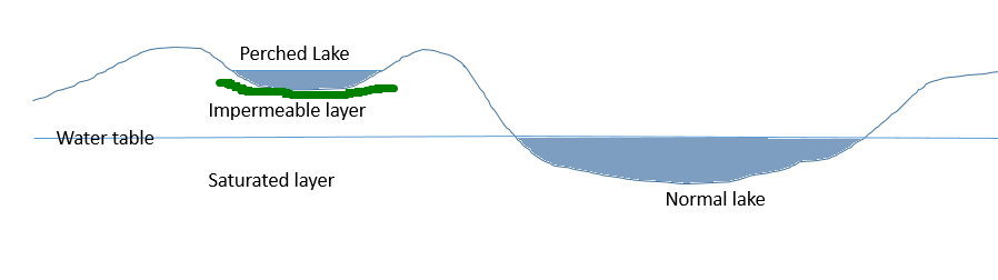
One example is Penny's Lagoon on King Island, where compacted vegetable matter and sand have "waterproofed" a depression, forming an impermeable layer to hold a perched lake.
Here at Lake Elizabeth, we have a different situation. Back in 1952, after one of the heaviest periods of rain on record for this area, a massive landslide carried many tonnes of rock and soil down the slopes and dammed the East Barwon River at this location, resulting in the formation of the lake in this remote forested valley. The ground in this area is a mixture of clays and forest material and has been able to hold the water, forming the lake.
Perched lakes are quite rare, and there are very few examples of them to be found.
Here at Lake Elizabeth, there is a short walk of about 1 km from the car park to the lake and GZ, and there is also the opportunity to circumnavigate the lake by taking a slightly up and down path of about 2 km in length. I recommend that you take the time to do the complete walk and you may need to go part of the way to accurately answer Q2.
Logging Tasks:
In order to qualify to log this earthcache, please send me answers to the following questions.
1. We know the event which caused this perched lake to occur happened in 1952. If we didn't know this, what can you see in the lake which might be able to give a clue as to the approximate time this event occurred?
2 . Go for a walk and see where the landslide debris is now. What has happened to it since the event occurred? You may get a clue about where it is from looking at a map initially, before your visual observation.
Your answers can be sent to me via the geocaching.com message or email system or by email to earthcaches@jamieson.id.au which will give me a notification on my phone allowing me to respond personally within an hour or two few hours. Of course, as per the guidelines for Earthcaches, you may log your find immediately, but I have the right to delete your find log if the questions are not answered within a reasonable timeframe.
Thank you for visiting this lovely location. I hope you chose to walk right around the lake.