The Old Red Sandstone is an assemblage of rocks in the North Atlantic region largely of Devonian age. It extends in the east across Britain, Ireland and Norway and in the west along the northeastern seaboard of North America. It also extends northwards into Greenland and Svalbard. In Britain it is a lithostratigraphic unit (a sequence of rock strata) to which stratigraphers accord supergroup status and which is of considerable importance to early paleontology. For convenience the short version of the term, ORS is often used in literature on the subject. The term was coined to distinguish the sequence from the younger New Red Sandstone which also occurs widely throughout Britain.
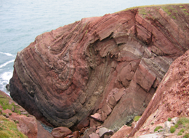
St Annes Head in Pembrokeshire
Caledonian orogeny
The Caledonian orogeny was a mountain building era recorded in the northern parts of Ireland and Britain, the Scandinavian Mountains, Svalbard, eastern Greenland and parts of north-central Europe. The Caledonian orogeny encompasses events that occurred from the Ordovician to Early Devonian, roughly 490–390 million years ago (Ma). It was caused by the closure of the Iapetus Ocean when the continents and terranes of Laurentia, Baltica and Avalonia collided.
The Caledonian orogeny is named for Caledonia, the Latin name for Scotland. The name was first used in 1885 by Austrian geologist Eduard Suess for an episode of mountain building in northern Europe that predated the Devonian period. Geologists like Émile Haug and Hans Stille saw the Caledonian orogeny as one of several episodic phases of mountain building that had occurred during Earth's history. Current understanding has it that the Caledonian orogeny encompasses a number of tectonic phases that can laterally be diachronous. The name "Caledonian" can therefore not be used for an absolute period of geological time, it applies only to a series of tectonically related events. br /> During the Ordovician, the small continent of Avalonia moved independently in a northeastern direction towards Baltica. This motion was accommodated by the subduction of the southeastern Iapetus Ocean (the so-called Tornquist Sea) beneath eastern Avalonia. In the Late Ordovician (about 450 million years ago) continental collision started between Avalonia and Baltica. The Tornquist Sea disappeared in the process, the remaining suture is the Tornquist line, which runs under the North Sea, southern Denmark and northern Germany and Poland.
The main phase of the Caledonian orogeny (from about 425 to 400 million years ago) is called the Scandian phase in Scandinavia and the Grampian phase in Britain. It was caused by the collision between Laurentia and Baltica. The Iapetus Ocean first closed in the north, then in the south. Therefore, the collision between Baltica and Laurentia took place a little earlier than that between Avalonia and Laurentia. Continental collision started in the Mid Silurian and mountain building took place in the Early Devonian (from 420–405 million years ago). In North America, the collision between Avalonia and Laurentia is called the Acadian orogeny. According to some authors, the Caledonian continental collisions involved another microcontinent, Armorica (southern Portugal, most of the north of France and parts of southern Germany and the Czech Republic), even smaller than Avalonia. This microcontinent probably did not form one consistent unit, but was instead a series of fragments, of which the current Armorican and Bohemian Massifs are the most important. The ocean between the combined continental mass of Laurentia, Baltica and Avalonia (called Euramerica, Laurussia or Old Red Continent) and Armorica is called the Rheic Ocean. The paleogeographic position of the Armorica crustal fragments between the Ordovician and Carboniferous is highly disputed though. There are indications that the Bohemian Massif started moving northward from the Ordovician onward, but many authors place the accretion of the Armorican terranes with the southern margin of Laurussia in the Carboniferous Hercynian orogeny (about 340 million years ago). The Rhenohercynian basin, a back-arc basin, formed at the southern margin of Euramerica just after the Caledonian orogeny. According to these authors, a small rim from Euramerica rifted off when this basin formed. The basin closed when these Caledonian deformed terranes were accreted again to Laurussia during the Hercynian orogeny.[

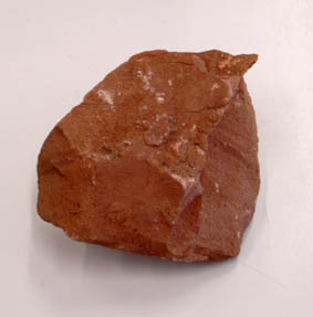
The Old Red Sandstone describes a suite of sedimentary rocks deposited in a variety of environments during the Devonian but extending back into the late Silurian and on into the earliest part of the Carboniferous. The body of rock, or facies, is dominated by alluvial sediments and conglomerates at its base, and progresses to a combination of dunes, lakes and river sediments. The familiar red colour of these rocks arises from the presence of iron oxide but not all the Old Red Sandstone is red or sandstone — the sequence also includes conglomerates, mudstones, siltstones and thin limestones and colours can range from grey and green through red to purple. These deposits are closely associated with the erosion of the Caledonian Mountain chain which was thrown up by the collision of the former continents of Avalonia, Baltica and Laurentia to form the Old Red Sandstone Continent- an event known as the Caledonian Orogeny. Many fossils are found within the rocks, including early fishes, arthropods and plants. The rocks may appear paleontologically barren to amateur geologists but careful study, particularly with an accomplished fossil hunter, can uncover pockets of fossils. Rocks of this age were also laid down in southwest England (hence the name 'Devonian') though these are of true marine origin and are not included within the Old Red Sandstone .
Old Red Sandstone
Now for your task:
1. If you look at the coordinates to the left, you can see the red sandstone. Guess the entire height of the coast and to what height the sandstone being exposed ?
2. What other colours can be seen in the Red Sandstone here?
3. Observe what angle the rock layers are?
4. From here you can see a rock fall. Describe the size and texture of the rocks.
5. Explain the possible reason for this rock fall.
Please make a photo of you with GPS coordinates to the above. After latest guidelines from the GC is not a log condition!
Send your answers to either Impossible-Idiots@web.de or via contact form or message center. Your picture load her please with the log high.
You can log immediately. We will contact you if something is wrong. Logs without email will be deleted!
Sources:
www.wikipedia.de
www.wikipedia.org

Old Red Sandstone
Der Old-Red-Sandstein ist eine Gesteinsformation von beträchtlicher Bedeutung für die Paläontologie und die historische Geologie. Von diesen in England und Schottland weit verbreiteten Gesteinen leiten sich die Bezeichnungen Old-Red-Fazies und Old-Red-Kontinent ab, die in der regionalen Geologie Europas eine weit über Großbritannien hinausreichende Bedeutung besitzen.
Der Old-Red-Sandstein ist eine überwiegend nach ihren roten Sandsteinen und Arkosen benannte Gesteinsfazies, die nach der Kaledonischen Orogenese im späten Silur, während des Devons und des unteren Karbons abgelagert wurde.
St Annes Head in Pembrokeshire
Kaledonische Orogenese
Die Kaledonische Orogenese ist die ältere der beiden mehrphasigen Gebirgsbildungen des nordamerikanisch-europäischen Paläozoikums. Sie begann im Ordovizium und hatte ihren Höhepunkt im Silur. „Kaledonisch“ stammt vom lateinisch-keltischen Namen Caledonia für Schottland.
Bei dieser paläozoischen Gebirgsbildung entstanden die heutigen Rumpfgebirge der Britischen Inseln, Skandinaviens und – im weiteren Sinne – die Appalachen im östlichen Nordamerika. Auch die Ostküste Grönlands, die Bäreninsel, die Orkney- und Shetlandinseln und West-Spitzbergen sind kaledonischen Ursprungs.
Während des Ordoviziums – vor etwa 450 Mio. Jahren – waren die erdgeschichtlichen Kontinente Laurentia, Baltica und Avalonia von hohen südlichen Breiten in Richtung Äquator gedriftet. Sie kollidierten in mehreren Phasen miteinander. Der Tornquist-Ozean zwischen Baltica und Avalonia und der Iapetus-Ozean wurden dabei geschlossen. Die bei der Subduktion und Schließung des Iapetus-Ozeans entstandenen Inselbögen und Gebirge werden heute als Kaledonische Gebirge bezeichnet, die damit verbundene bzw. zugrunde liegende Gebirgsbildung als Kaledonische Orogenese.
Der genaue Ablauf dieser Kollisionen im Zeitraum ist nicht im Detail bekannt. Als wahrscheinlich gilt folgender Ablauf: Im Obersten Ordovizium kollidierte zuerst Avalonia mit Baltica. Vermutlich bildete Avalonia einen vulkanischen Inselbogen, bevor es mit Baltica kollidierte. Vor der Ostküste Laurentias bildete sich ein Inselbogen aus, unter den der Iapetus subduziert wurde. Im Silur wurde der Iapetus vollständig geschlossen. Es entstanden in mehreren Phasen die Irisch-Schottischen Kaledoniden und die Skandinavischen Kaledoniden. Der Inselbogen vor der Ostküste Laurentias wurde in die Appalachen eingefaltet. Dieser Ast setzt sich auch an der Ostküste Grönlands bis Spitzbergen und der Bäreninsel fort. In Nordamerika entstanden die Appalachen. Ein neuer Großkontinent – Laurussia oder Old Red Kontinent – war entstanden.
Die Old-Red-Fazies wird beherrscht von Sedimenten wie Sandsteinen, Arkosen, Siltsteinen und Konglomeraten. Sie lässt sich zwei Ablagerungsgebieten zuordnen: zum einen dem Kerngebiet in England, Schottland und Westnorwegen, das ausschließlich meeresferne Ablagerungen zeigt, zum anderen einem ausgedehnten, im Devon an das Meer grenzenden Gürtel von überwiegend rotgefärbten Sedimenten, der sich vom südwestlichen England über Frankreich, Belgien und Deutschland bis in das östliche Baltikum verfolgen lässt. Im Kerngebiet des Old Red sammelten sich die Ablagerungen vorwiegend in Sedimentbecken an, welche nach der Kaledonischen Orogenese im Gebiet des noch jungen Gebirges abgelagert wurden. Das in diese Becken geschüttete Material entstammte meistens der unmittelbaren Umgebung, die Ablagerungen erreichten Mächtigkeiten von bis zu 7.000 m. Die Abfolgen des Old Red werden gegliedert durch Diskordanzen, die hier eine grobe Dreiteilung des Old-Red-Sandsteins zulassen. Anzeichen der Ablagerungsbedingungen sind Schrägschichtung, Wellenrippeln und Trockenrisse, die für den älteren Teil des Old Red zusammen mit der geringen und auf wenige Stellen konzentrierten Fossilführung eine Entstehung in Flüssen und Seen unter semiaridem Klima belegen. Dünenablagerungen und Windkanter im Zusammenhang mit der Bildung von ausgedehnten Bodenkrusten sind die Anzeichen dafür, dass der jüngere Teil des Old Red in wüstenhaftem Klima abgelagert wurde..
Old Red Sandstein
Nun zu eurer Aufgabe:
1. Wenn du an den Koordinaten nach links schaust, siehst du den roten Sandstein. Schätze die gesamte Höhe der Küste und in bis zu welcher Höhe der Sandstein hier offen liegt.
2. Welche Farbe hat der Sandstein hier außer rot?
3. Beobachte in welchem Winkel die Gesteinsschichten liegen?
4. Von hier aus sieht man einen Felssturz. Beschreibe die Größe und Beschaffenheit der Felsbrocken.
5. Erkläre den möglichen Grund für diesen Felssturz.
Macht bitte ein Foto von euch mit GPS an den o.a. Koordinaten. Nach neuesten Richtlinien von GC ist das jedoch keine Logbedingung!
Schickt eure Antworten entweder an Impossible-Idiots@web.de oder übers Kontaktformular bzw. Messagecenter.
Euer Bild ladet ihr bitte mit dem Log hoch.
Ihr dürft sofort loggen. Wir melden uns falls etwas nicht stimmt. Logs ohne Email werden kommentarlos gelöscht!
Quellen:
www.wikipedia.de
www.wikipedia.org