
Versione italiana:
Consiglio: Portatevi un picnic! È l’unico verso di miglioramento. ;-) Inoltre la via dalla riva al GC permette altre viste bellissime. Buon divertimento!
Di sicuro ci sono troppo pochi geocaches in questa regione rispetto alla quantità di posti ameni e luoghi da vedere presenti. È per questo che ho deciso di metterci un geocache. Vorrei farvi vedere il panorama spettacolare.
Nel listing vi aspettano qualche domande. Mandate le risposte a me in forma di un breve messaggio - se possibile in inglese, per favore. Dopo potete registrare nel log. Se qualcosa è sbagliato, vi do notizia.
Geographia e storia dell’origine:
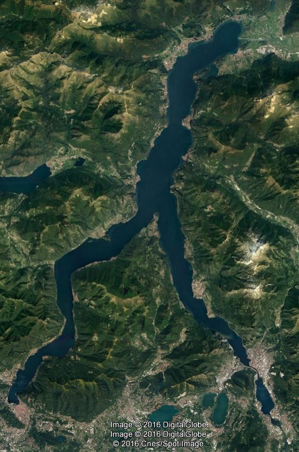
Il Lago di Como è un lago nella Lombardia in Italia.
I romani lo chiamavano Larius Lacus, i locali semplicemente Lario. Ha un‘area di 146 chilometri quadrati – dunque è il terzo lago d’Italia per estensione, dopo il Lago di Garda e il Lago Maggiore. Riguardo al perimetro è il più grande. La profondità massima si trova a Nesso con 425 m. Il fondo del lago è situato a 200 m sotto il livello del mare.
Il Lago di Como è di origine glaciale. Si trova dove in precedenza era presente il ghiacciaio Adda, che ha scavato e formato il bacino. Quando? Il ghiacciaio sorgeva durante l’ultimo periodo glaciale, la glaciazione würmiana, quando i ghiacciai ricominciarono a crescere.
Excursus:
A questo proposito è importante sapere che con “periodo glaciale”, di cui stiamo parlando, non si intende “era glaciale”. Non dobbiamo confondere le definizioni, che hanno significati completamente diversi. Un’era glaciale contiene sia periodi glaciali che interglaciali (periodi caldi). Noi stiamo vivendo in un periodo interglaciale. Questo significa che l’ultimo periodo glaciale è finite, ma ci troviamo ancora nella stessa era glaciale – che finirà solamente quando le calotte polari non saranno più ghiacciate.
Ma tornando al lago: il ghiacciaio che formava la valle esisteva nel glaciale recente. Si ritirò all’inizio dell’interglaciale, nel quale viviamo noi (il cosidetto Olocene). Ormai sono passati 10.000 anni, un periodo brevissimo nel contesto geologico.
Affluendo dalle Alpi il ghiacciaio veniva diviso nei bracci di Como e Lecco. Questa è la causa della forma caratteristica di un „Y“ inverso. Secondo me da questo posto si può immaginare proprio bene come il ghiacciaio spingeva tra la valle e la scavava.
Oggi due fiumi, Mera e Adda, sfociano nel lago al posto del ghiacciaio che 10.000 anni fa spariva. Entrambi sfociano nel Lago di Como vicino a Colco proveniendo da Nord-est. La Mera proviene dal vicino Lago di Mezzola a Nord-est. L’Adda proviene da Est sfociando nel lago allo stesso lato e si alimenta grazie all’unione dei laghi di Cancano e San Giacomo di Fraele. L’Adda è l’affluenza principale e scorre attraverso il lago intero fino a Lecco, uscendo di nuovo. L’altro braccio non ha uno scarico.
Particolarmente in seguito a precipitazioni intense nel bacino idrografico si vede come il fiume attraversa il lago con l’acque mischiandose relativamente poco. E visibile a causa del carico portato dal fiume. È costituito da carico in sospeso – solido fino, come argilla e limo, che va portato nel fiume in suspensione. È costituito anche da carico soluto – sostanze quali sono soluti d’acqua acida. Ciò accade per esempio in un contesto geologico calcareo come nel massiccio alpino. --> Da questa posizione, si può osservare bene questo processo geologico.
Le Alpi sono fatti di calcare. Ora alcuni più dettagliate informazioni circa: Nel caso in cui si desidera saperne di più.
Origine chimica
Determinante per la formazione chimica del calcare è il prodotto di soluzione del CaCO3 (1) [Ca2+] · [CO32-] = L = 4,9·10-9 e gli stadi di dissociazione dell'acido carbonico: (2) [H+] · [HCO3-]/[H2CO3] = K1 = 1,72·10-4 (3) [H+] · [CO32-]/[HCO3-] = K2 =4,84·10-11 Alla diminuzione della concentrazione degli ioni di idrogeno, risulta aumentata secondo l'equazione (2) la concentrazione degli ioni di bicarbonato e secondo la (3) la concentrazione degli ioni di carbonato. Si perviene in tal modo alla precipitazione dovuta al superamento per eccesso del prodotto di solubilità del carbonato di calcio. Un aumento della concentrazione degli ioni di idrogeno porta invece a una diminuzione della concentrazione di ioni di carbonato secondo l'equazione (3) e quindi a un superamento per difetto del prodotto di solubilità del carbonato di calcio, ossia a una soluzione rinforzata del carbonato di calcio.
Carbonato di calcio si è difficilmente solubile in acqua pura. La solubilità è 14 milligrammi per litro, mentre lo ione carbonato come ioni di bicarbonato in soluzione solo una volta. In presenza di anidride carbonica disciolta solubilità aumenta ma da più di un centinaio di volte. L'erosione del calcare e le forme di bicarbonato di calcio facilmente solubile è basato su questo effetto. : 
Origine organogena
La formazione organogena del calcare deriva dal fatto che molti esseri viventi sono dotati di un guscio o scheletro calcareo. Dopo la morte di tali organismi, i resti dopo un percorso più o meno lungo vanno a fondo, deponendosi sul fondale marino. Dopo la decomposizione delle parti molli, le parti mineralizzate formano sedimenti che ricoprono aree sovente di notevole estensione. Ad esempio, le melme a globigerina coprono oggi il 37,4% del fondo del mare, che corrisponde al 25,2% dell'intera superficie terrestre. Tra gli esempi fossili, le rocce calcaree del Muschelkalk ("calcare conchigliare" del Triassico della Germania) sono costituite in gran parte da resti di conchiglie di molluschi. Esistono anche organismi che contribuiscono attivamente alla costruzione di strutture mineralizzate, come ad esempio i coralli, e danno luogo a vere e proprie scogliere organogene. In questo caso gli organismi vivi crescono sugli scheletri delle generazioni precedenti, formando con le loro strutture un intreccio nel quale i vuoti vengono progressivamente colmati da cementi e/o da sedimento. Un classico esempio di quest'ultimo tipo di organismi dal passato geologico sono le Rudiste, bivalvi vissuti nel Cretaceo che potevano dare luogo a biocostruzioni di notevole estensione. Recenti studi [1][2] hanno suggerito per i sedimenti marini una ulteriore sorgente di carbonato di calcio: i pesci teleostei, ossia i pesci con scheletro osseo. Questi sono in grado di produrre grandi quantità di carbonato di calcio nei loro intestini come una risposta osmoregolatrice alla continua ingestione di acqua di mare, ricca in calcio e magnesio, espulsi come rifiuti. Questo carbonato di calcio, più ricco in magnesio rispetto a quello planctonico, e quindi più solubile, viene stimato che possa costituire dal 3% al 15% della produzione totale di carbonato oceanico e contribuire fino a un quarto del bilancio del carbonato di calcio di origine marina; questi dati potrebbero spiegare l'abbondante distribuzione di carbonato nei primi 1000 metri superiori delle masse d'acqua marine.
(Capitolo al calcare: wikipedia.org)
...
Informazioni supplementari interessanti:
Il Lago di Como è diventato ricco per l’allevamento di bachi da seta e l’industria di seta risultante. Il clima mediterrano consente la coltivazione di tante piante subtropicali, come palme, agrumi, cipressi e olivi. Questo, insieme alle montagne intorno e i villaggi situati sulla riva, costituiscono il fascino del lago.
Persone celebri come George Clooney, Madonna, Brad Pitt o Donatella Versace hanno qui una casa delle vacanze. Il Lago di Como è spesso utilizzato come scenario cinematografico. Per esempio, sono stati girati qui Star Wars: Episode II, Casino Royale o Ocean’s 12.
(Fonte: cambiato in base a Wikipedia)
Ecco le altre domande:
- Veniendo di quale direzione di vista e direzione cardinale si faceva passare il ghiacciaio per la valle?
- Si può vedere da qui la foce del fiume del cui valle prima proveniva il ghiacciaio che ha creato la valle?
- L’attraversamento del lago per il fiume spesso è visibile in colori diversi. Da dove deriva questa colorazione?
- Prova a descrivere il colore e il corso del fiume nel lago (nel centro, a margine e dove? Fino a dove è visibile circa?). [Casomai il flusso non sia visibile quel giorno e quindi non si vedono i colori, perchè non mi descrivi il tempo ;-)]
- La strada ha una particolarità, quale? Perché pensi sia stato fatto A) Scanalature modellate B) Mosaico C) Striature con colori alternati D) Gradini E) Acciottolato
Spero che questo luogo vi sia piaciuto quanto è piaciuto a me e anche che vi siano state utili le informazioni che vi ho dato con il Cache. Per favore non postate foto che rispondano alle domande. Buona discesa!
Tanti saluti,
il, la, lo Anjuta

English version
There are definitely too little geocaches in this region in comparison to the amount of lovely spots and worth seeing locations that exist here. That is why I decided to place a Cache here. From the location you will have a distinguished view that I really like to show you.
In the listing you will find some few questions. Please send your answers as a little message to me. AFTERWARDS you can just log it. Is there anything wrong I will contact you.
So I wish you will have a lot of fun to reach the location, with a beautiful view in magnificent sunshine and of cause with the information, too.
Geography and formation history:
Lake Como (Lago di Como) is a lake in the region called Lombardy in the north of Italy. The romans called it Larius Lacus, the locals just Lario. It has an area of 146 square kilometers (56 sq mi), making it the third-largest lake in Italy, after Lake Garda and Lake Maggiore. Looking the outline, it is the biggest one. The maximum depth is at Nesso with 425m (1395 feet). The bottom of the lake is more than 200 metres (660 ft) below sea level.
Excursus:
Here it is important to know that the definition of glacial age (what is also known as ice age) is not the same as the definition of a glacial stage, we are talking about now. Please don’t do the mistake to mix these definitions. They mean totally different things. A glacial age or ice age includes cold periods (glacial states) as well as warm periods (interglacial states). In such a warm period we are living today. This means the cold period is gone, but we are still living inside the same ice age – this continues as long as the poles are covered with ice.
But back to the lake here: The glaciers that formed the valley appeared in the last cold period and went back at the beginning of the warm period we are living in now (called Holocene). This is just 10 000 years ago, what is pretty short in the context of geology.
When it flew down the Alps it split in two arms. That is why the lake got the characteristic form like the letter “Y”. From this place, you are standing at the moment you can especially imagine how the glacier slowly ran through the valley and shaped it.
Today two rivers flow into the lake, where 10 000 years ago the glacier end slowly disappears. Both rivers enter the lake near Colico today, coming from the northeast – the “Mera” and the “Adda”. The Mera comes from the nearby “Lago di Cancano”. The Adda comes from the eastern direction and has a much longer distance. It originates from the “Lago di Cancano” that is connected to the “Lago di San Giacomo di Fraele”. The Adda is the primarily inflow that flows through the whole lake and flows out at Lecco. The other lake arm has no outflow. Especially after heavy rainfalls in the catchment area of the rivers you can recognize the river flowing through the lake in which it does not really mix with the lake water. You can see it because of the load of the river. One part of it is the suspension load - what are particles as clay and silt transported by the river. And it is as well as the solution load – what is material that is dissolved by acidic water, what happens for example where the geology is limestone. Te results of this geological process can be watched well from this place.
The alps consist of limestone - Therefore now some detailiertere information about it. Not necessary to read, just in case you want to know more.
About 10% of all sedimentary rocks are limestones. Limestone is partially soluble, especially in acid, and therefore forms many erosional landforms. These include limestone pavements, pot holes, cenotes, caves and gorges. Such erosion landscapes are known as karsts. Limestone is less resistant than most igneous rocks, but more resistant than most other sedimentary rocks. It is therefore usually associated with hills and downland, and occurs in regions with other sedimentary rocks, typically clays.
Karst topography and caves develop in limestone rocks due to their solubility in dilute acidic groundwater. The solubility of limestone in water and weak acid solutions leads to karst landscapes. Regions overlying limestone bedrock tend to have fewer visible above-ground sources (ponds and streams), as surface water easily drains downward through joints in the limestone. While draining, water and organic acid from the soil slowly (over thousands or millions of years) enlarges these cracks, dissolving the calcium carbonate and carrying it away in solution. Most cave systems are through limestone bedrock. Cooling groundwater or mixing of different groundwaters will also create conditions suitable for cave formation. Coastal limestones are often eroded by organisms which bore into the rock by various means. This process is known as bioerosion. It is most common in the tropics, and it is known throughout the fossil record (see Taylor and Wilson, 2003). Like most other sedimentary rocks, most limestone is composed of grains. Most grains in limestone are skeletal fragments of marine organisms such as coral or foraminifera. Other carbonate grains comprising limestones are ooids, peloids, intraclasts, and extraclasts. These organisms secrete shells made of aragonite or calcite, and leave these shells behind when they die.
Limestone often contains variable amounts of silica in the form of chert (chalcedony, flint, jasper, etc.) or siliceous skeletal fragment (sponge spicules, diatoms, radiolarians), and varying amounts of clay, silt and sand (terrestrial detritus) carried in by rivers. Some limestones do not consist of grains at all, and are formed completely by the chemical precipitation of calcite or aragonite, i.e. travertine. Secondary calcite may be deposited by supersaturated meteoric waters (groundwater that precipitates the material in caves). This produces speleothems, such as stalagmites and stalactites. Another form taken by calcite is oolitic limestone, which can be recognized by its granular (oolite) appearance.
The primary source of the calcite in limestone is most commonly marine organisms. Some of these organisms can construct mounds of rock known as reefs, building upon past generations. Below about 3,000 meters, water pressure and temperature conditions cause the dissolution of calcite to increase nonlinearly, so limestone typically does not form in deeper waters (see lysocline). Limestones may also form in lacustrine and evaporite depositional environments.
Calcite can be dissolved or precipitated by groundwater, depending on several factors, including the water temperature, pH, and dissolved ion concentrations. Calcite exhibits an unusual characteristic called retrograde solubility, in which it becomes less soluble in water as the temperature increases.

Impurities (such as clay, sand, organic remains, iron oxide, and other materials) will cause limestones to exhibit different colors, especially with weathered surfaces. Limestone may be crystalline, clastic, granular, or massive, depending on the method of formation. Crystals of calcite, quartz, dolomite or barite may line small cavities in the rock. When conditions are right for precipitation, calcite forms mineral coatings that cement the existing rock grains together, or it can fill fractures. Travertine is a banded, compact variety of limestone formed along streams; particularly where there are waterfalls and around hot or cold springs. Calcium carbonate is deposited where evaporation of the water leaves a solution supersaturated with the chemical constituents of calcite. Tufa, a porous or cellular variety of travertine, is found near waterfalls. Coquina is a poorly consolidated limestone composed of pieces of coral or shells. During regional metamorphism that occurs during the mountain building process (orogeny), limestone recrystallizes into marble.
(Chapter about limestone: wikipedia.org)
...
Interesting information (aside of physical geographie):
The Lace Como is becoming rich in the 15th Century because of the rearing of silkworms and the upcoming silk industry. The climate is generally mild and Mediterranean-like that is why sub-tropical plants can grow year-round e.g. palms, citrus fruits, cypress and olive trees. This in addition to the surrounding mountains and the many villages lying at the lakeside, give the lake a special charm. Well-known prominent people like George Clooney, Madonna, Brad Pitt oder Donatella Versace have their holyday residence at the lake. Also the lake is used in several Films as film location, e.g. in Star Wars: Episode II, Casino Royale or Ocean’s 12.
(Source: Wikipedia - modified)
So here are the questions you should answer to log:
- From what direction did the glacier come to mill into the valley and shape the form of the lake?
- Is it possible to see the mouth of the river that is written above and from whose valley the glacier once has been recharged.
- The rivers flow through can often be seen here because of the different color of the water. Where does the coloring came from?
- Try to describe the color as well as the way of the flow through of the river (in the middle, at the side – if yes where? Up to where can you see it?). [If the flow through and in this case either the color cannot be seen at the day of your visit, describe the weather instead. ;-)]
- The road is having something special – what is it? And what do you think, why this is made? A) Milled striation B) Mosaic floor C) Alternating striated in terms of color D) Steps E) Cobblestone
I hope you liked the location as well as I did and I also hope you enjoyed the cache with all the information I composed for you, too. Please do me a favor and do not post photos on which people can see the answers to the questions. ;-) Now thanks for doing this cache and have a nice walk down the hill.
Greetings from Germany,

Deutsches Listing:
Da es hier eindeutig zu wenige Geocaches für die zahlreichen sehenswerten Lokalitäten gibt, habe ich beschlossen wenigstens einen Cache hier zu legen. Diese Stelle bietet eine herausragende Aussicht, die ich euch gerne zeigen möchte.
Im Listing erwarten euch einige wenige Fragen. Bitte sendet eure Antworten als kleine Nachricht an mich. DANACH könnt ihr einfach loggen. Ist was falsch melde ich mich bei euch.
Ich wünsche euch ganz viel Spaß mit dem Cache und des Erreichen dieses und eine tolle Aussicht bei herrlichem Wetter. Die einzige Möglichkeit, es noch besser zu machen, ist indem ihr euch ein Picknick mitnehmt und dieses dort genießt. ;) Übrigens haben wir die Stelle beim Wandern entdeckt. – Beim Aufstieg von der Seeseite aus, gibt es noch einige sehenswerte Aussichten mehr. Also viel Spaß.
Geographie und Entstehungsgeschichte:
Der Comer See (Lago di Como) liegt in der norditalienischen Region Lombardei. Die Römer nannten den See Larius Lacus, die Einheimischen nennen ihn auch einfach Lario. Der See hat eine Fläche von 146 km², eine Länge von 51km und eine max. Breite von 4,2 km. Flächenmäßig ist er der drittgrößte See Italiens nach dem Gardasee und dem Lago Maggiore. Vom Umfang her ist es sogar der größte See. Seine maximale Tiefe liegt mit 425m bei Nesso. Der Seegrund liegt mehr als 200m unter dem Meeresspiegel.
Der Comer See liegt in einem Zungenbecken des ehemaligen Addagletschers, von welchem er ausgeschabt und geformt wurde. Wann? Der Gletscher entstand im letzten Glazial, der sogenannten Würm-Kaltzeit, als die Gletscher der Erde wieder zu wachsen begannen.
Exkurs:
Hierbei ist es wichtig zu wissen, dass eine Eiszeit nicht das gleiche ist wie eine Kaltzeit (genannt Glazial), über welche wir hier sprechen. Bitte verwechselt diese Definitionen nicht, da sie etwas völlig anderes bedeuten. Eine Eiszeit beinhaltet sowohl Kaltzeiten (Glaziale) als auch Warmzeiten (Interglaziale). In solch einer Warmzeit leben wir heute. Das heißt die letzte Kaltzeit ist vorüber, aber wir leben noch immer in derselben Eiszeit – die erst endet, wenn die Polarkappen nicht mehr eisbedeckt sind.
Doch zurück zu diesem See hier: Der Gletscher, der das Tal formte, kam in der letzten Kaltzeit. Er zog sich dann zu Beginn der Warmperiode, in der wir nun leben (dem sogenannten Holozän), wieder zurück. Dies ist erst 10.000 Jahre her, was im Erdgeschichtlichen Kontext sehr kurz ist.
Als er von den Alpen herabfloss splittete sich der Gletscher in die zwei Arme von Como und Lecco auf. Daher hat der See heute seine charakteristische Form eines umgekehrten „Y“. In finde, dass man sich an dem Ort, an dem du gerade stehst, besonders gut vorstellen lässt, wie der Gletscher sich durch das Tal des Sees schob und dieses ausschabte.
Heutzutage fließen zwei Flüsse an der Stelle in den See, an der vor 10.000 Jahren der Gletscher langsam wieder verschwand. Beide Flüsse münden bei Colico von Nordosten her kommend in den Lago die Como, die „Mera“ und „Adda“. Die Mera kommt vom nahegelegenen „Lago di Mezzola“ im Nordosten. Die Adda fließt aus östlicher Richtung kommend am gleichen Ende in den See und wird aus dem deutlich weiter entfernten Seeverbund aus „Lago di Cancano“ und „Lago di San Giacomo di Fraele“ gespeist wird. Sie ist der Hauptzufluss und durchfließt den gesamten See bis sie ihn bei Lecco wieder verlässt. Der andere Seearm besitzt keinen Abfluss. Besonders nach stärkeren Niederschlägen im Einzugsgebiet der Flüsse, lässt sich gut erkennen, wie der Fluss den See durchfließt und sich dabei verhältnismäßig wenig mit dem Seewasser vermischt. Man sieht ihn aufgrund der Flussfracht, die er mit sich führt. Diese besteht aus Schwebfracht – feinem Festmaterial, wie Ton und Lehm, dass als Suspension im Fluss mitgeführt wird. Aber sie besteht auch aus Lösungsfracht – Stoffe welche durch saures Wasser gelöst wurden, was beispielsweise bei einer kalksteinreichen Geologie geschieht. --> Von dieser Stelle aus lässt sich dieser geologische Prozess gut beobachten.
Die Alpen bestehen vorwiegend aus Kalkstein. Daher kommen nun ein paar tiefergreifende Informationen. Vorausgesetzt ihr wollt noch tiefer gehende Infos. Diese sind zur Beantwortung der Fragen nicht nötig.
Kalkstein besteht überwiegend aus den Mineralen Calcit und Aragonit, zwei Kristallisationsformen von Calciumcarbonat (kohlensaures Calcium CaCO3). In mehr oder minder schwankenden Anteilen kommen andere Minerale vor. Dazu zählen Tonminerale, Dolomit (CaMg(CO3)2), Quarz, Gips und andere. Überwiegt der Dolomitanteil, so spricht man vom Gestein Dolomit. Besitzt der Kalkstein einen relativ hohen Anteil an Tonmineralen, so bezeichnet man ihn dann als Mergel. Kalkstein kann auch bis zu mehreren Prozent organische Substanz enthalten und wird dann bituminöser Kalk (bei Vorhandensein von Schwefelwasserstoff auch Stinkkalk) genannt.
Kalksteine können innerhalb der Sedimentgesteine mehreren Typen angehören. Der überwiegende Teil der Kalksteine ist aber biogenen Ursprungs, das heißt, er wurde von Lebewesen gebildet und abgelagert. Kalkstein kann aber auch durch chemische Prozesse (die wiederum von Lebewesen beeinflusst werden können) aus dem Wasser ausgefällt werden. Weiterhin kann ein Gestein, welches aus Calciumcarbonat besteht (Kalkstein oder Marmor), abgetragen, transportiert und an anderer Stelle als klastisches Sediment wieder abgelagert werden. Bei biogener Herkunft wird Kalkstein meistens von Mikroorganismen oder gesteinsbildenden Korallen abgelagert. Untergeordnet findet man auch Kalksteine, die zum überwiegenden Teil aus Schnecken, Muscheln oder Schwämmen bestehen. In jedem Fall besteht das Gestein dann aus Calciumcarbonat, welches Bestandteil der Lebewesen war und zum Aufbau von Außen- oder Innenskeletten abgeschieden wurde.
Chemisch und biogen ausgefällter Kalkstein
Natürlich vorkommendes Wasser (sowohl Meer- als auch Süßwasser) enthält immer in mehr oder weniger großen Mengen Calciumcarbonat, für gewöhnlich wird es als Calciumhydrogencarbonat gelöst, da seine Löslichkeit deutlich größer ist als die des Carbonat-Ions. Wird Carbonat bis zur Sättigung der Lösung zugeführt oder sinkt umgekehrt das Löslichkeitsvermögen des Wassers, so wird Calciumcarbonat aus der übersättigten Lösung ausgefällt. Dieses war vorher kein Bestandteil von Lebewesen. Damit können Kalksteine Bestandteil von Evaporitserien sein. Innerhalb der Eindampfungsfolge tritt Kalkstein wegen der vergleichsweise geringen Löslichkeit des Carbonats an der Basis der Gesteinsserie auf. Er wird als erstes abgeschieden. Im Hangenden folgt meist Gips und darüber die leicht löslichen Salzgesteine, zum Beispiel Steinsalz. Im Meer können Calcitkristalle nur in den obersten 200 m abgeschieden werden, da in größeren Tiefen durch den zunehmenden Wasserdruck die Löslichkeit für Kohlendioxid zunimmt und deshalb keine übersättigten Lösungen mehr auftreten. Die ausgefällten Kristalle können aber bis zur Carbonatkompensationslinie absinken.
Die Fällung des Calciumcarbonats kann völlig ohne Beteiligung von Lebewesen ablaufen, wird aber meist durch die Aktivität von Lebewesen (vor allem Algen, im Süßwasser auch Moose) unterstützt. Die Photosynthese der Pflanzen verbraucht das Kohlendioxid im Wasser, so dass zur Beibehaltung des Lösungsgleichgewichtes Hydrogencarbonat-Ionen sich wieder in Kohlendioxid und Carbonat-Ionen aufspalten. Da Carbonat-Ionen deutlich schlechter löslich sind als Hydrogencarbonat-Ionen, wird nun verstärkt Calcit aus der Lösung ausgefällt. Die Fällung des Calcits geschieht sowohl innerhalb der Wassersäule als auch am Grunde von Gewässern direkt am Untergrund. Im ersten Fall bilden sich im Wasserkörper mikroskopisch kleine Kristalle, die zu Boden sinken und dort ebenfalls Kalkschlämme bilden. Ihre Diagenese führt dann zu einem festen Kalkstein. Im zweiten Fall wachsen die Calcitkristalle direkt auf andere Kristalle am Gewässergrund auf, so dass sie sich auch in Fließgewässern absetzen können. Dieser Mechanismus ist für die Entstehung von Travertin bzw. Kalktuff notwendig.
Verwitterung des Kalksteins, Karst und Süßwasserkalke
Wegen der vergleichsweise guten Löslichkeit des Carbonats ist Kalkstein ein gegenüber der chemischen Verwitterung relativ anfälliges Gestein und bildet daher spezielle Lösungsformen aus. Umgekehrt kann aber das gelöste Carbonat wieder ausgefällt werden und ebenfalls spezielle Gesteine und Formen (Kalktuff, Kalksinter, Travertin) hervorbringen. Beides wird unter der Bezeichnung Verkarstung oder Karst zusammengefasst. Auf der Verwitterung ausgesetzten Kalksteinen bildet sich ein charakteristischer Bodentyp heraus, die Rendzina. Verwittert Kalkgestein im Untergrund, entstehen Höhlen. Im Zusammenspiel verschiedener Faktoren bilden sich Tropfsteinhöhlen. Die Tropfsteine in diesen Höhlen wachsen als Kalksinter.
Calciumcarbonat selbst ist in reinem Wasser kaum löslich. Die Löslichkeit beträgt gerade einmal 14 Milligramm pro Liter, wobei das Carbonat-Ion als Hydrogencarbonat-Ion in Lösung geht. Bei Anwesenheit von gelöstem Kohlenstoffdioxid steigt die Löslichkeit jedoch um mehr als das Hundertfache. Auf diesem Effekt beruht die Verwitterung von Kalkgestein, wobei sich das leicht lösliche Calciumhydrogencarbonat bildet.
Wegen seiner Löslichkeit ist Calciumhydrogencarbonat ein Bestandteil der meisten natürlichen Gewässer, je nach Gestein in unterschiedlichen Konzentrationen.
(Kapitel über Kalkstein: Wikipedia.org)
...
Interessante Informationen (abseits der physischen Geographie):
Der Comer See wurde im 15.Jh. durch die Seidenraupenzucht und die dadurch entstandene Seidenindustrie reich. Durch das mediterrane Klima gedeihen viele subtropische Pflanzen wie z. B. Palmen, Zitrusfrüchte, Zypressen und Olivenbäume. Diese, zusammen mit den umgebenden Bergen und den vielen am Ufer liegenden Dörfern, machen den Charme des Sees aus.
Prominente wie George Clooney, Madonna, Brad Pitt oder Donatella Versace besitzen ein Feriendomizil am See. Der Comer See dient immer wieder als Filmkulisse, beispielsweise wurde hier für Star Wars: Episode II, Casino Royale oder Ocean’s 12 gedreht.
(Quelle: verändert nach Wikipedia)
Hier nun die Fragen:
- Aus welcher Richtung kommend, fraß sich der Gletscher durch das Tal?
- Lässt sich von hier aus die Flussmündung des oben genannten Flusses sehen, aus dessen Tal einst der Gletscher gespeist wurde, der das Tal schuf?
- Das Durchfließen des Sees durch den Fluss ist oft aufgrund der unterschiedlichen Farben zu erkennen. Woher kommt diese andere Färbung?
- Versuche die Farbe und den Verlauf des Flusses im See zu beschreiben (mittig, am Rand – wenn ja wo? Bis wohin ist er etwa zu sehen?). [Falls sich an dem Tag der Durchfluss und damit die Farbe nicht erkennen lässt, beschreibe mir doch das Wetter. ;-)]
- Die Straße weist hier eine Besonderheit auf, welche ist das? Was glaubst du warum dies vermutlich hier gemacht wurde? A) Gefräste Rillen B) Mosaikbilder C) Farblich abwechselnde Streifen D) Stufen E) Kopfsteinpflaster
Ich hoffe euch hat die Stelle auch so gut gefallen wie mir und dass ihr auch den Cache mit den für euch zusammengestellten Informationen genossen habt. Bitte postet keine Fotos, die die Fragen beantworten und habt einen guten Abstieg.
Viele Grüße,
der, die, das Anjuta