Formation
L'archipel est un morceau de la plaque australienne, détachée du supercontinent Gondwana au Crétacé.
(Il y a environ 70 millions d'années), et dont la formation s'est faite par une série de plissements de la plaque, dont le dernier s'est produit aux âges éocène et oligocène (entre environ 53 et 26 Ma), expliquant la multiplicité des types et âges de sol : à la fois formations sédimentaires et volcaniques s'étalant du Permien (299 à 251 Ma) au Tertiaire (entre 65 et 1,5 Ma).
La Grande terre et les îles qui la prolongent au nord ouest et au sud est, sont l'émergence de la partie terminale nord de la ride de Norfolk qui s'étend au sud jusqu'à la Nouvelle-Zélande et qui est en partie uen relique d'un bloc continental détaché du super continent de Gondwana vers la fin du crétacé il y a 85 MA. ce bloc aujourd'hui en grande partie ennoyé, est dénommé Zelandia.
A l'est, les îles Loyauté font partie d'un arc volcanique.
La Grande terre est constituée en majeure partie de formations sédimentaires et volcaniques dont les âges vont du Permien (225-280 MA) au Cénozoique ou tertiaire (1,5 - 65 MA). Certaines formations de la chaine pourraient être plus anciennes que le Permien mais leur âge n'est pas déterminé. Les formations les plus anciennes annant du Permo-Carbonifère au Jurassique proviendraient d'arcs et sédiments volcaniques collés à la marge orientale du bloc Gondwanien lors de sa dérive.
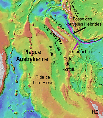
Plusieurs époques de plissements sont répertoriées. Ces plissements et charriages résultent de collisions de plaques. Le dernier, d'âge éocène à oligocène (Paléogène, 26-65 MA), a constitué l'île actuelle.
Ce plissement du Tertiaire est marqué par l'obduction (passage d'éléments d'une plaque sur une autre) de la plaque Pacifique sur la Plaque Australienne avec charriage associé d'un plancher océanique basaltique, puis de roches ultrabasiques sur celui-ci.
Les formations basaltiques situées majoritairement sur la côte Ouest sont les restes de cet ancien plancher océanique. Les importants ensembles de roches ultrabasiques résultant de l'obduction sont en superficie parmi les plus importants au monde bien que supplantés par les formations ultrabasiques d'Oman. Ils proviennent d'un feuillet du manteau (situé sous l'écorce terrestre ou lithosphère) .Cet affrontements de plaques avec les subductions associées a généré des conditions de température et de pression qui ont transformé une partie des sédiments et roches volcaniques.
Ce phénomène appelé métamorphisme est à l'origine des schistes, micaschistes et des intéressantes éclogites bleues du Nord de la Grande Terre. Ces roches contiennent du glaucophane (une amphibole bleue). Ce métamorphisme à glaucophane dit de "schistes bleus" s'effectue sous de très hautes pressions. Les micaschistes et autres roches à glaucophane sont rarement aussi étendus dans le monde.
Jusqu'au Crétacé la Nouvelle-Calédonie faisait partie de la marge orientale du super-continent de Gondwana qui, bien que déjà fortement fragmenté, contenait encore l'Australie et l'Antarctique. Les formations les plus anciennes (du Permien au Jurassique et anté-Permien) proviennent de ce continent et de formations de bassins intra-océaniques accrétées à sa marge.
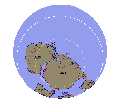 La plaque Australienne il y a 100 Millions d’années
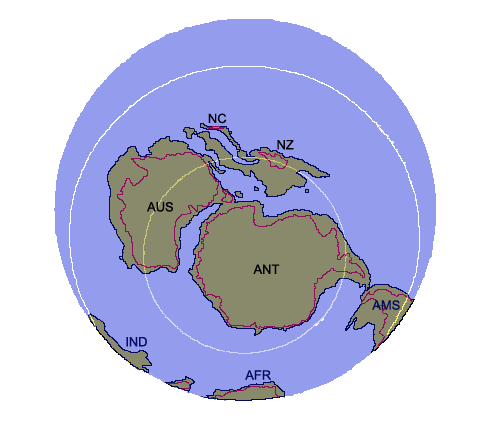 La plaque Australienne il y a 70 Millions d’années
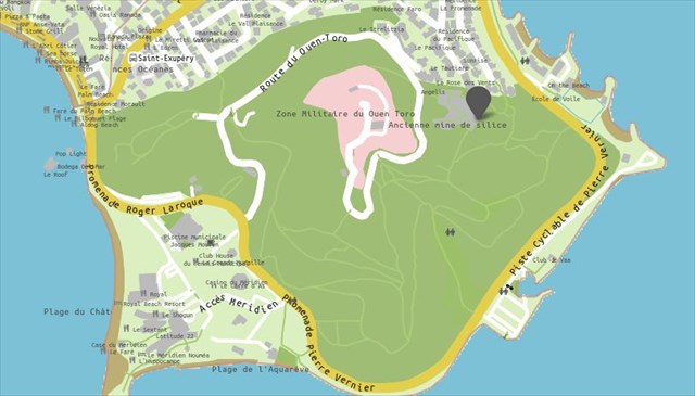
Géomorphologie de la région de Nouméa
Son terrain est essentiellement composé de flyschs sédimentaires datées dans une fourchette allant du Priabonien à l'Éocène moyen, associés à quelques terrains allochtones isolés, ou klippes, de roches silicieuses (cherts ou phtanites) et calcaires (moitié ouest de la presqu'île de Nouville, la pointe sud de la péninsule autour du Ouen Toro), et à certains îlots plus anciens remontant au Sénonien et donc au Crétacé (autour de la baie des Citrons dans le sud-ouest de la péninsule, Tina au nord-est). L'essentiel des terrains des communes du Grand Nouméa sont d'âge Sénonien, avec une large bande littorale de terrains volcano-sédimentaires du Lias (Jurassique) autour de l'embouchure de la Dumbéa.
Elle dispose d'un relief accidenté constitué de plusieurs collines (Ouen Toro, Montravel, mont Coffyn, mont Vénus, etc.), culminant à celle de Montravel à 167 mètres au-dessus du niveau de la mer.
Pour faire un « Found it » sur cette cache il vous faudra répondre aux trois questions suivantes et de manière optionnelle prendre une photo de vous ou de votre GPS au point virtuel de la cache (pas aux waypoints intermédiaires s’il vous plait). Vous pouvez loguer la cache sans attendre mon retour. Toutefois, je me réserve le droit de supprimer votre « Found It » si vos réponses sont fausses.
Q01 : WP01
Vous pouvez voir la dégradation du terrain. Quelles couleurs sont présentes
Q02 : WP02
Vous vous trouvez au bas de la colline. Décrivez la forme des strates (orientation et épaisseur)
merci de votre visite et bon séjour sur le Caillou
ENGLISH
Formation
The archipelago is a piece of the Australian plate, separated from the supercontinent Gondwana during the Cretaceous.
Australian plate drift eastward and dips (subduction) under the Pacific plate west of the volcanic archipelago of Vanuatu. The subduction zone is marked by an underwater pit (pit of the New Hebrides) with a depth of about 7000 m. (There are about 70 million years), and whose training was done by a series of folds of the plate, the last of which occurred in the Eocene and Oligocene age (about 53 to 26 Ma) explaining the multiplicity of soil types and ages: both sedimentary and volcanic formations spanning the Permian (299-251 Ma) Tertiary (65 to 1.5 Ma).
The “Grande Terre” and the islands that extend the northwest and southeast, are the emergence of the terminal part of the north Norfolk ridge that extends south to New Zealand and is partly a relic of a detached landmass of Gondwanaland super late Cretaceous ago 85 million years. This block now largely flooded, is referred to Zelandia. To the east, the Loyalty Islands are part of a volcanic arc (Arc "Loyalty").
“Grande Terre” consists largely of sedimentary and volcanic formations whose ages range from Permian (225-280 million years ago) to the Cenozoic or Tertiary (1.5 to 65 AD). Some courses of the chain could be older than Permian but their age is not determined. The oldest formations from the Permian-Carboniferous to Jurassic originate arches and volcanic sediments stuck to the eastern margin of the Gondwana block at its drift.
Several periods of folding are listed. These folding and thrusting results of plate collisions. The latter, of Eocene to Oligocene age (Paleogene, 26-65 AD), formed the current island. This folding of the Tertiary was marked by the obduction (elements of transition from one plate to another) of the Pacific plate on the Australian Plate with thrust associated with a seafloor basalt and ultrabasic rocks on it. Basaltic formations located mainly on the west coast are the remains of this ancient ocean floor. The important sets of ultrabasic rocks resulting from obduction area are among the largest in the world although supplanted by ultramafic formations of Oman. They come from a slip mantle (below the earth's crust, or lithosphere) .This clashes plates associated with subduction generated conditions of temperature and pressure that transformed part of sediments and volcanic rocks. This phenomenon is called metamorphism originally shales, mica schist and eclogite interesting blue North of Grande Terre. These rocks contain glaucophane (blue amphibole). This metamorphism glaucophane called "blueschists" takes place under very high pressures. Mica schists and other rocks glaucophane are rarely as extensive in the world.
La plaque Australienne il y a 100 Millions d’années
La plaque Australienne il y a 70 Millions d’années
Until the Cretaceous New Caledonia was part of the eastern margin of the supercontinent Gondwana, which although already highly fragmented, still contained Australia and Antarctica. The oldest formations (Permian to Jurassic and ante-Permian) come from that continent and trainings intra-oceanic basins accreted to its margin.
Geomorphology of the Nouméa region
Its terrain is mainly composed of dated sediment flysch in the range of Priabonian the Middle Eocene, associated with some isolated non-native land, or klippes of siliceous rocks (cherts or phtanites) and limestone (western half of the peninsula Nouville, the southern tip of the peninsula around the Ouen Toro) and some older islands dating back to Senonian and therefore the Cretaceous (around the Bay of Lemons in the southwest of the peninsula, Tina northeast). Most of the land municipalities of Greater Nouméa are Senonian age, with wide coastal strip of volcano-sedimentary rocks of the Lias (Jurassic) around the mouth of the Dumbéa13.
It has a rugged terrain consists of several hills (Ouen Toro, Montravel, Coffyn Mount, Mount Venus, etc.), culminating in that of Montravel to 167 meters above the level of the sea.
To make a "Found it" on this cache you must answer the following three questions and optionally take a picture of you or your GPS to the virtual point of the cache (not at the intermediate waypoints please). You can log the cache without waiting for my return. However, I reserve the right to remove your "Found It" if your answers are wrong.
Q01: WP01
You can see the degradation of the land. What colors are present ?
Q02: WP02
You are at the bottom of the hill. Describe the form of strata (orientation and thickness)