Glacial Lake Whittlesey and the Caradoc Sand Plain
Fourteen thousand years ago, the last glaciers to cover Ontario started to melt and recede northward. The area around the present Great Lakes was much lower in elevation than it is now, due to the weight of the ice on the land. Subsequently, the glacial meltwater pooled and formed a huge lake which covered present day Lake St. Clair, Lake Erie, and parts of Michigan, Ohio and Pennsylvania. Much of the soil and rock particles that had been scraped by the 2km thick ice layer from the north was brought south by glacial movement. When the glaciers melted, this sandy soil was deposited into the new Lake Whittlesey. Much of this particulate matter sank to the lake bottom and formed a thick layer of sedimentation. As temperatures rose, about 12,000 ybp (years before present), the land started to rise again (rebound) and large rivers formed which started to drain Lake Whittlesey.
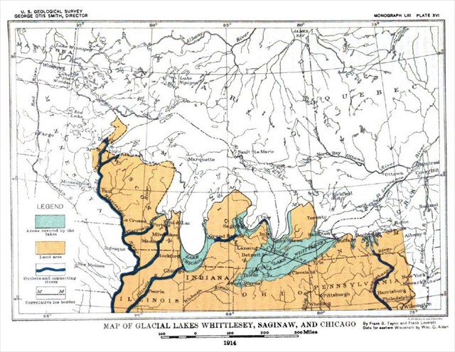
Some areas became river deltas where huge amounts of sandy loam soils were deposited. The area where Longwoods Road Conservation Area is situated is part of that delta, now called the Caradoc Sand Plain. Once the temperatures increased further, the waters draining Lake Whittlesey became raging torrents, carving out large valleys which you can observe at Longwoods Road C.A.. The sandy soil was carried southward and helped form the beaches along Lake Erie we enjoy today.
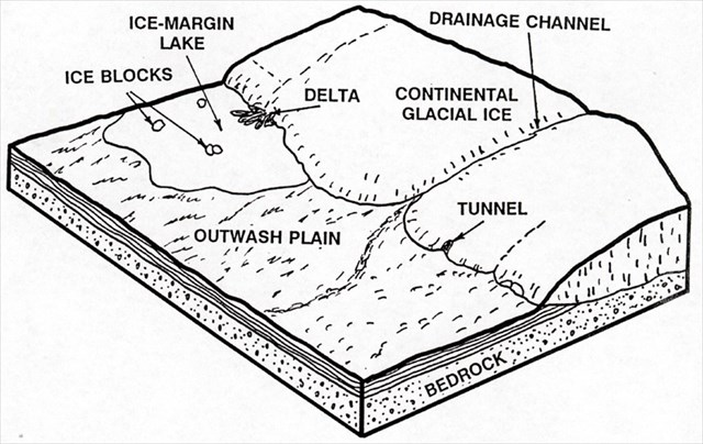
The location you are standing is one such carved our river valley. It doesn't look like much today, the flow of water, but it was once much deeper and the flow rate quite a bit stronger and faster.
To get credit for this Earthcache email the CO the answers to the following questions;
1. What was the name of the lake that was here as the ice started to retreat?
2. Which direction is the small creek of today flowing?
3. What would make you think from observing the ravine you are in that the stream or river that once was here carved the ravine rather than the creek below the bridge?
4. What is the altitude at the bridge at the bottom and the platform at the top of the stairs? This will give you the depth of the ravine. Bonus. How wide is the ravine at the top of the stairs from side to side? You can use your GPS to estime the distance. Set it at the top of the stairs for coordinates then walk through the ravine then up the other side.
5. Because of the size and depth of this ravine being within a Carolinian forest zone something quite unusual is created. What is it? Does this seem evident to you by what you see here and feel? The answer to this can be seen on a small information sign at the bottom of the stairs to the east. Describe your observations. Do you agree or disagree?
Optional. Post a picture of the ravine. Include you with your GPS or just your GPS if you wish or just post a nice natural scene of what it looks like on your visit.
Congratulations to carnigrewal and tiggrrr for the first to find.