Warning: Check the water level before trying this cache. If you try this when the water level is too high, you will not make it. It is extremely dangerous. When the water level is below 40 CFS (see the link to Jones Bar water flow below), you can easily walk through and the rating would probably be 4/4. I will do my best to disable this adventure cache when the rains start and the water level rises. Even at low levels you need to take your time and watch your footing there are many slippery places, and places you might have to wade.
Check water levels Cubic feet /second (CFS) at Jones bar, which is a bit below highway 49. On September first, when I took the low picture, the water was flowing at 35 CFS.
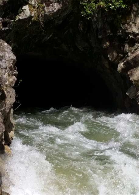
 This was an image I took on September 1st, with the river running 35 CFS.
 This was an image I took around March when I was scouting the tunnel .
The Miners Tunnel History
1849-1855 -- At first, the gold pan extracted large nuggets for the few who were lucky. But by the mid-1850's gold mining techniques were rapidly advancing. The pan gave way to the rocker, then the sluice box, then Long Tom (mentioned in Diary of a 49er).
Men became extremely industrious, to the point that the "Miner's Tunnel", built in 1879, is now on National Register of Historic Places. It is 800 feet long through solid rock between Hwy. 49 and Hoyt's Crossing. The purpose was to divert the flow of the South Yuba during summer months, so that the miners could work the dry river bed undisturbed.
The tunnel right of way was sold by William Clymo in 1877 to John Jacka & Company for $21.00 who formed the South Yuba River Mining Tunnel Company. The Tunnel was sold in 1881 to George Emory at a nice profit. The sale amount was $12,061. River bed mining and ground sluicing became the norm, with men banding together to form mining companies to consolidate their resources. Evidence of these early mining activities are found throughout the South Yuba River Project.
Getting to the cache: Recommended route is via the East Independence trail. Parking and reference points will refer to this route. It can also be reached via the river, from either direction, or from Hoyts trail. Take the East Independence trail (parking coords given) until it intersects with Excelsior Ditch Camp Road (about 2 miles). Turn left and head down the steep trail. When the trail splits, head left again. When you reach the river, go straight down to the bank, and find the tunnel outlet. This is the decision time. Do not enter or even put your legs into any kind of strong current.
Caching Requirements: A picture of the tunnel exit, just like the 2 above, and the water flow of the river on the day you went through. Include this with your log. If it is safe to go in, travel carefully. At about the center of the tunnel, look for a preform soda bottle container in an old dynamite slot, it fits perfectly. I had a larger container for a Hybrid letterbox, but it wouldn't fit, so this letterbox doesn't have room for anything except the log sheet.