King Ravine EarthCache
-
Difficulty:
-

-
Terrain:
-

Size:  (other)
Please note Use of geocaching.com services is subject to the terms and conditions
in our disclaimer.
King Ravine in Randolph, NH is a great wild place to explore. This rocky valley is one of several ravines in the Presidential Range of the White Mountains formed by the glaciers that once blanketed most of the Northeast – there are 15 ravines in the Presidential Range: Tuckerman Ravine being the most famous.
There are many ways to get to King Ravine but the "easiest" way is to park at Appalachia on Rte.2 in Randolph, NH and hike up the Air Line to the Short Line which connects to the King ravine Trail. The hike is about 6 miles round trip.
Geologically, King Ravine is known as a cirque. A cirque is a steep bowl shaped hollow at the upper end of a mountain valley as illustrated in the photo below.
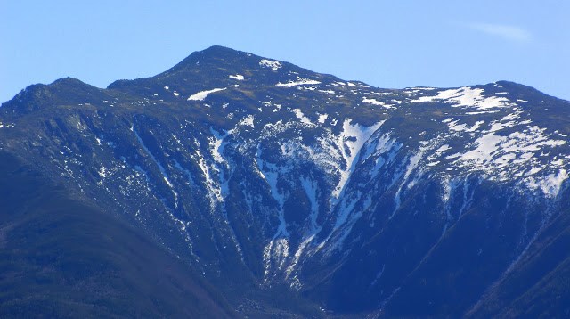 King Ravine – note the steep sides of the upward slopes
Formation of Cirques: Glacial cirques are found among mountain ranges throughout the world; 'classic' cirques are typically about one kilometer long and one kilometer wide. Situated high on a mountainside they are typically partially surrounded on three sides by steep cliffs. The highest cliff often is called a headwall. The fourth side forms the lip, headwall or sill; the side at which the glacier flowed away from the cirque. Many glacial cirques contain small ponds or tarns dammed by either till (debris) or a bedrock threshold. When enough snow accumulates it can flow out the opening of the bowl and form valley glaciers which may be several kilometers long.
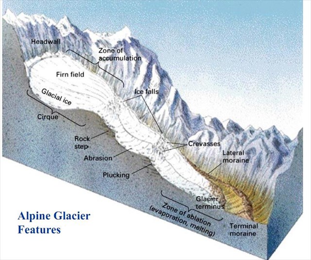
Cirques form in conditions which are favorable; in the northern hemisphere the conditions include the northeast slope where they are protected from the majority of the sun’s energy and from the prevailing winds: King Ravine faces north. These areas are sheltered from heat, encouraging the accumulation of snow; if the accumulation of snow increases, the snow turns into glacial ice. The formation of the ice erodes the vertical rock face and causes it to disintegrate, which may result in an avalanche bringing down more snow and rock to add to the growing glacier. Eventually, this action may become large enough that glacial erosion intensifies. The enlarging of this open ended concavity creates a larger leeward deposition zone, furthering the process of glaciation. Debris (or till) in the ice also may abrade the bed surface; should ice move down a slope it would have a ‘sandpaper effect’ on the bedrock beneath, on which it scrapes.
Formation of King Ravine: There has been debate when exactly King Ravine and other Presidential Range cirques were developed, however, most agree that between and after the last continental glaciations, alpine glaciers occupied and steepened the deep cirques of the Presidential Range including King Ravine. What makes King Raving unique is that the floor of King Ravine is a jumbled mass of boulders that have fallen from the extremely steep rock walls above. Thirty years ago it was discovered that these jumbled boulders represented the remnants of a rock glacier. A rock glacier is formed when rocks fall by various methods from the steep surrounding walls onto an existing ice glacier sometimes completely covering the ice and no additional ice covers the rocks. The rock glacier acts like an ice glacier and slowly flows down the valley until the ice eventually melts which explains the tongue of jumbled rocks/boulders on the valley floor and the absence of a typical moraine ridge.

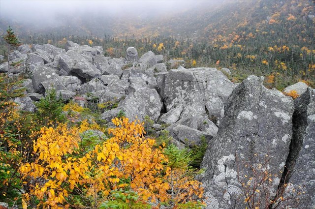 Floor of King Ravine looking north down the valley Close up look at remnants of rock glacier
REQUIREMENTS:
Please email me the answers to the questions below. You do not have to wait for a response from me to log your find.
1) At the given coordinates is a sign. To prove you were there what does the second line read on the BOTTOM sign?
2) Hopefully it is a clear day. Look up at the headwall and explain how it was formed and explain why King Ravine is a cirque. If it is cloudy look at a topographical map.
3) Observe the terrain at the coordinates. What evidence indicates that this was once a rock glacier? Where do you think the rock glacier ended? Why?
Resources:
Davis, P. Thompson, “Cirques of the Presidential Range, New Hampshire, and Surrounding Alpine Areas in the Northeastern United States, 1999.
Goldthwaith et. al., The Geology of New Hampshire, 1951.
Wikipedia – numerous entries and photos.
Congrats to DocRoss for FTF
Additional Hints
(No hints available.)
Treasures
You'll collect a digital Treasure from one of these collections when you find and log this geocache:

Loading Treasures