
Geology of Ely
The geology of Cambridgeshire spans two broad geological periods, the Jurassic and the Cretaceous. To the west the older limestone beds of the Jurassic period make up the bulk of the bedrock while to the east it's the chalk deposits of the more recent Cretaceous period. In between these two is some higher ground formed by a ridge of Lower Greensand capped by Boulder Clay. Until relatively recently, before the land was drained for farming, this Lower Greensand ridge formed a series of islands, which rose above the surrounding waterlogged flat lands. Kimmeridge Clay partly underlies the Lower Greensand in some areas of Cambridgeshire and in others the ridge was partially capped by glacial deposits. Ely sits atop one such area of glacial deposits, making it one of the highest points in the surrounding countryside.
The flat peatland of the area surrounding Ely formed at the end of the Ice Age, about 10,000 years ago. As the ice melted the sea level rose and the land was worn away in the tides from the Wash. Over time the inland forests became marsh, which through the rise and fall of the tides left a layer of clay, which turned the decaying vegetation into peat. The peat Fens provided good subsistence for the island settlements, and Ely had several thriving industries including eels, reeds and willow. However the settlements embanked their land in order to prevent flooding, and this created problems with silting downstream, which frustrated navigation. So in the mid 17th century the peatlands were drained and straight cuts designed to take water to the sea faster, with sluices preventing the tides running far inland. While initially unsuccessful subsequent generations introduced pumps to help drain the Fens faster so that by the 1820s the land surrounding Ely was much as you see it today - higher ground of small settlements punctuating broad, flat field systems.
Ely Cathedral
While the bedrock below the town of Ely is broadly Lower Greensand, above that there are various different superficial deposits that make up the landscape as you see it today. These superficial deposits include areas of sand and sand mixed with gravel. It's these superficial deposits that have impacted on the history of the cathedral, in quite a dramatic fashion.

As the above plan shows Ely Cathedral, much like any other ancient structure in the world, was not built as you see it today in one single period of construction. It has been added to over time in several stages. The full history of the building is not the purpose of this EarthCache, though it is interesting. However the superficial deposits just below the surface had an important role to play in the history of the cathedral, specifically the different building phases from the Norman period to the late 14th century.
The Norman structure of Ely Cathedral was very different to the one that you can see today, however significant sections of the Norman construction remains in place. For one thing the Norman church wasn't as tall as the modern cathedral, and it was symmetrical when viewing it from the west.
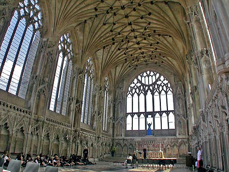
One important addition to the structure of the church was the Parish Church of the Holy Trinity to the north east of the main building, now known as the Lady Chapel, which was completed in the early 14th century. The chapel features a stone vaulted ceiling (pictured above), which is incredibly heavy and is supported only by the outer walls of the chapel. The design of the chapel therefore needed to include significant buttresses, the foundations of which were dug to twelve feet - not a massive depth by today's standards, but at the time this was unheard of. However due to the high water table of the local area water from the surrounding sandy deposits drained into the foundations, drying out the ground in the immediate area and making it unstable. This directly led to the collapse of the Norman east tower in 1322, which took out part of the presbytery on its way down. Today if you take the tower tour (highly recommended, though it's not wheelchair accessible and you have to pay for it) you can clearly see the distinction between the original Norman presbytery and the 14th century rebuild.
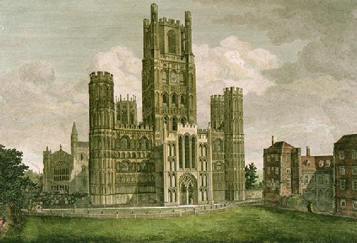
The superficial geology also impacted 14th century building works to the west of the cathedral building. In the late 14th century an extension was added to the West Tower, increasing its height by about sixty feet. The land the tower is built on was never meant to take that kind of weight, and over time the tower sank into the ground by three feet, and developed a subtle list to one side. The lower towers to the north of the West Tower, shown on the left in the artist's impression below, also collapsed at about this time.
Onto this EarthCache!
As this is an EarthCache there is no physical container to find. Instead answer the questions below and send them to me via email or message centre using the link on my user profile at the top of the page. You may post a found log without receiving a response from me, although I do endeavour to respond to all emails and messages I receive. Any found logs without a corresponding email or message will be deleted.
- The West Tower is leaning slightly to one side. There are subtle indicators as you look at the building as to which side it is leaning, roughly to the north, or to the south. Are you able to work out in which direction the tower is leaning?
- The land beneath the cathedral is a mixture of superficial deposits of sand, and sand with gravel. Which of these two deposits do you think sits to the north of the West Tower, and which to the south? Please explain your answer.
- (Optional) Please upload a photograph with your log of yourself at the cathedral.
Please note that you do not need to enter the cathedral to answer the questions for this EarthCache, though it is highly recommended as it is a beautiful building both inside and out. Permission for this EarthCache has been very kindly given by the Director of Communications and Commerce at Ely Cathedral.