Welcome to Thompson’s Beach, an appropriately named and convenient sand bar for todays Earth Science lesson. Please note the river level will dictate weather or not you can stand right at GZ, as long as you make it to Thompson’s Beach, and can access some sand and the waters edge you will be able to adequately complete this earth cache. ** You will need a clear plastic container or bottle to conduct a basic experiment. Please be river safe, never swim alone or dive into the river, sand bars are constantly shifting.
To help you understand how Thompson’s was formed we have included some definitions and a couple of basic diagrams.
A river is a natural flowing watercourse, usually freshwater, flowing towards an ocean, sea, lake or another river. Rivers are part of the hydrological cycle. Water generally collects in a river from precipitation through a drainage basin from surface runoff and other sources such as groundwater recharge, springs, and the release of stored water in natural ice and snowpacks. Strait rivers are common in areas with higher water velocity where there is a steeper sloap. Meandering, curved rivers occur where the topography is less elevated with a lower water velocity.
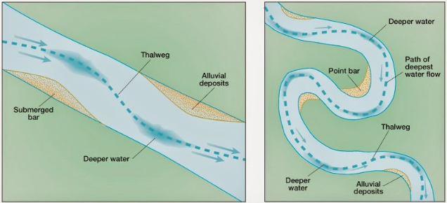
A bar in a river is an elevated region of sediment (such as sand or gravel) that has been deposited by the flow. Types of bars include mid-channel bars (also called braid bars, and common in braided rivers), point bars (common in meandering rivers), and mouth bars (common in river deltas). Bars are typically found in the slowest moving, shallowest parts of rivers and streams, and are often parallel to the shore and occupy the area farthest from the thalweg.
The locations of bars are determined by the geometry of the river and the flow through it. Point bars form on the inside of meander bends in meandering rivers because the shallow flow and low shear stresses there reduce the amount of material that can be carried there. The excess material falls out of transport and forms the bar.
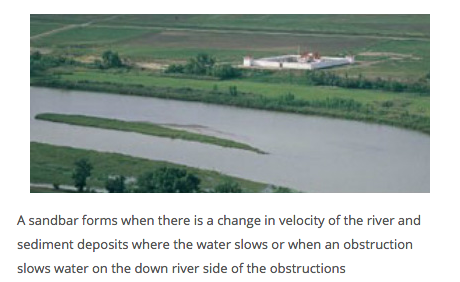
Braid bars, or mid-channel bars, are landforms in a river that begin to form when the discharge is low and the river is forced to take the route of less resistance by means of flowing in locations of lowest elevation. Over time, the river begins to erode the outer edges of the bar, causing it to become a higher elevation than the surrounding areas. The water level decreases even more as the river laterally erodes the less cohesive bank material resulting in a widening of the river and a further exposure of the braid bar. As the discharge increases, material may deposit about the braid bar since it is an area in the river of low velocity due to its increased elevation in relation to surrounding areas. During times of extremely high flow, the bars may become covered; only to resurface when the flow decreases. Most braid bars do not remain stable or in one location. However, vegetation succession on braid bars can increase the stability of the landform. They are commonly composed of sand or gravel and typically occur in braided rivers.
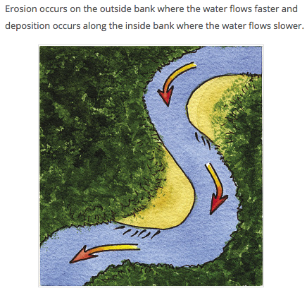
A point bar is a depositional feature made of alluvium that accumulates on the inside bend of streams and rivers below the slip-off slope. Point bars are found in abundance in mature or meandering streams. They are crescent-shaped and located on the inside of a stream bend, being very similar to, though often smaller than, towheads, or river islands.
Point bars are composed of sediment that is well sorted and typically reflects the overall capacity of the stream. They also have a very gentle slope and an elevation very close to water level. Since they are low-lying, they are often overtaken by floods and can accumulate driftwood and other debris during times of high water levels. Due to their near flat topography and the fact that the water speed is slow in the shallows of the point bar they are popular rest stops for boaters and rafters. However, camping on a point bar can be dangerous as a flash flood that raises the stream level by as little as a few inches (centimetres) can overwhelm a campsite in moments.
A point bar is an area of deposition whereas a cut bank is an area of erosion. Point bars are formed as the secondary flow of the stream sweeps and rolls sand, gravel and small stones laterally across the floor of the stream and up the shallow sloping floor of the point bar.
A cut bank, also known as a river cliff or river-cut cliff, is the outside bank of a water channel (stream), which is continually undergoing erosion. Cut banks are found in abundance along mature or meandering streams, they are located on the outside of a stream bend, known as a meander, opposite the slip-off slope on the inside of the bend. They are shaped much like a small cliff, and are formed by the erosion of soil as the stream collides with the river bank. As opposed to a point bar which is an area of deposition, a cut bank is an area of erosion.
A pendant bar is a fluvial geomorphology term that is usually applied to large landforms created by large scale flooding events. Pendant bars are thin, sharp-crested deposits, and are typically made up of coarser sediment from the bed load. This type of bar is found on the downstream side of a weathering-resistant protrusion such as a large outcrop of bedrock, and is separated from the protrusion by a depression.
Typically, cut banks are nearly vertical and often expose the roots of nearby plant life. Often, particularly during periods of high rainfall and higher-than average water levels, trees and poorly placed buildings can fall into the stream due to mass wasting events. Given enough time, the combination of erosion along cut banks and deposition along point bars can lead to the formation of an oxbow lake.
Not only are cut banks steep and unstable, they are also the area of a stream where the water is flowing the fastest at a higher pressure and often deeper, making them rather dangerous. Geologically speaking, this is known as an area of high-energy.
Material eroded here is deposited downstream in point bars.
In geography and fluvial geomorphology, a thalweg is the line of lowest elevation within a valley or watercourse. Under international law, thalwegs can acquire special significance because disputed river borders are often deemed to run along the river's thalweg as was the case with New South Wales and Victoria which uses the Murray river as the majority of its state border.
Sediment is a naturally occurring material that is broken down by processes of weathering and erosion, and is subsequently transported by the action of wind, water, or ice, and/or by the force of gravity acting on the particles. For example, sand and silt can be carried in suspension in river water and on reaching the sea be deposited by sedimentation and if buried this may eventually become sandstone and siltstone, ( sedimentary rocks).
Sediments are most often transported by water (fluvial processes), but also wind (aeolian processes) and glaciers. Beach sands and river channel deposits are examples of fluvial transport and deposition, though sediment also often settles out of slow-moving or standing water in lakes and oceans. Desert sand dunes and loess are examples of aeolian transport and deposition. Glacial moraine deposits and till are ice-transported sediments.
Secondary Flow, Water flowing through a bend in a river must follow curved streamlines to remain within the banks of the river. The water surface is slightly higher near the concave bank than near the convex bank. (The concave bank has the greater radius, and the convex bank has the smaller radius.) As a result, at any elevation within the river the water pressure is slightly higher near the concave bank than near the convex bank. There is a pressure gradient from the concave bank toward the convex bank. Centripetal forces are necessary for the curved path of each parcel of water, and this centripetal force is provided by the pressure gradient.
The primary flow around the bend is vortex flow – fastest speed where the radius of curvature is smallest and slowest speed where the radius is largest. The higher pressure near the concave bank is accompanied by slower water speed, and the lower pressure near the convex bank is accompanied by faster water speed, and all this is consistent with Bernoulli's principle.
There is also a secondary flow in the boundary layer along the floor of the river bed. The boundary layer is not moving fast enough to balance the pressure gradient and so its path is partly downstream and partly across the stream from the concave bank toward the convex bank, driven by the pressure gradient. The secondary flow is then upward toward the surface where it mixes with the primary flow or moves slowly across the surface, back toward the concave bank. This motion is called helicoidal flow.
On the floor of the river bed the secondary flow sweeps sand, silt and gravel across the river and deposits the solids near the convex bank, in similar fashion to sugar or tea leaves being swept toward the centre of a bowl or cup as described above. River bends often have a convex bank, which is shallow and made up of sand, silt and gravel; and a concave bank which is steep and heavily eroded. This process can lead to formation of a meander or a point bar or, eventually, an oxbow lake.
To log this Earth Cache we require you to wander around and look at the area, conduct two short experiments and consider the information given, perhaps you will need to do some research of your own, then message us with the following answers to the best of your ability;
1. Find a leaf or piece of bark, place it in the water and watch what happens to it, does it move away from you fast or slow? Does it automatically make its way downstream? Can you find another area of water that will take the leaf on a different path? What is this an example of?
2. What type of Bar is Thompson’s Beach?
3. What does the existence of Thompson’s Beach suggest about the water velocity here?
4. Using your clear container or bottle, collect some water from the river, describe what you see, what is this an example of? What happens if you let the water settle for awhile? How many distinct layers are there?
5. Explore the Beach a little, does the grain size of the sand seem consistent for the entire bar or does it change, explain why or why not this is the case.
6. A photo of your team, GPS or the view with your log please. (Optional)
You are welcome to log your find straight away to keep your TB's and Stats in order but please message us with your answers within 24 hours. Cachers who do not fulfil the Earth Cache requirement will have their logs deleted.

Source: Marka's Earth Science, Wikipedia, aerialgeologist.