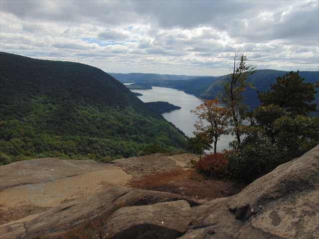
Breakneck Ridge is considered by many to be the toughest hike in the LoHud. The majority of the hike is a rock scramble and in less than 3/4 of a mile, the trail ascends more than 1250 feet! There are many spots along the trail that offer excellent views of the Hudson River making it a popular hike as well.
Breakneck Ridge is part of the Hudson Highlands, which is a section of the Reading Prong. The Reading Prong stretches from Reading, Pennsylvania, Northeast through New Jersey and New York into Connecticut. The Reading Prong is known to contain unusually high uranium concentrations. I know that iron, arsenic, sulfur, graphite, emery and lead were all mined in this area though I'm not aware of any uranium mines or deposits in the area. If anyone has a Geiger counter and would like to find out, please share your findings in your log.
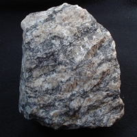
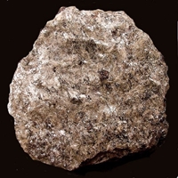
The Hudson Highlands is rugged, hilly to mountainous terrain composed of ancient gneiss and schist once buried many miles below the Earth's surface. Gneiss is a metamorphic rock (formed by heat and pressure) formed by high-grade metamorphism of pre-existing rock. Gneiss is coarse/medium grained and often banded, or foliated. Schist is a medium grade metamorphic rock with medium to large, flat, sheet like grains in a preferred orientation. Schist is coarse/medium/fine grained that can be foliated.
 |
 |
|
Gneiss
|
Schist
|
Some of the rock has been estimated at 1.3-1.1 billion years with the oldest known rocks at Earth's surface going back to 3.8 billion year! The Hudson Highlands were formed during the mountain building event known as the Greenville Orogeny during which older rocks and sediments were subject to deep burial and metamorphic alteration. Following the Greenville Orogeny, a long period of uplift and erosion occurred. Over the course of millions of years, the older rock was brought to the surface and the Hudson Highlands became the way that we know them today.
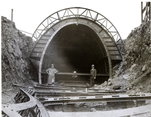
The Catskill Aqueduct is one of the greatest 20th Century engineering marvels built. The Catskill Aqueduct is 163 miles long and begins at the Ashokan Reservoir. It carries 500 million gallons of water each day at a flow rate of 4 feet per second to the Kensico Reservoir from which water is delivered to New York City. Construction was started in 1907 and was completed in 1915. The entire system including 3 dams and 67 shafts was completed in 1924 at a cost of $177 million. One of the most impressive feats of engineering is that the Catskill Aqueduct crosses beneath Storm King (the mountain directly across the river) and Breakneck Ridge at a depth of 1200 feet! From where you are standing at the posted coordinates (approximate elevation is 800 feet), the Catskill Aqueduct is located 2000 feet below you! Geologists had predicted that solid rock would be found at a depth of 400-500 feet but after some drilling, it was found to be located more than a 1000 feet below the river bed. After several options were assessed, a tunnel through solid rock was determined to be the most satisfactory. The reason this particular location was chosen for the tunnel was because it is believed that the old bed of the river lies everywhere many hundreds of feet below the present bottom.
Logging Requirements
- Observe some of the bedrock in the area. Based on the information given in the cache description, is Breakneck Ridge composed of gneiss or schist? What lead you to that conclusion?
- While climbing from the road below, does the rock type change? What signs of erosion do you see?
- Once you reach the coordinates, is the rock more smooth or pointed/edgy? Why do you think this is the case?
- Why was this particular location chosen for the location where the Catskill Aqueduct would cross the Hudson River? What feature of the local rock made it particularly suitable to sustain such a tunnel? Why wouldn't tunneling through river sediment be a good idea?
- (Optional) Upload some pictures of the view or any wildlife that you may encounter.