This earthcache looks at the erosion and deposition on the River Ken in Silver Woods.
The River Ken's source is near Blackborough, up on the edge of the Blackdown Hills. It flows down, through Kentisbeare and joins the River Culm just south of Cullompton.
**********************
LOGGING TASKS
Please send me the answers through email or Message Centre. If you log a find and don't send answers within 24 hours or so your log risks being deleted.
- Looking at the riverbank, give evidence to show where one of the 4 erosion types has happened. Please state which type and where you can see it happening. You might find it easier to have a paddle in order to answer this one!
- Given many many years of erosion here, what do you think will happen to the course of the river? Use the information below to help.
- How do you think heavy rainfall and floods speed up or slow down erosion?
To prove you visited:
- Further into the woods you'll see some logs for people to sit on, how many are there?
- Estimate the width and depth of the river here.
**********************
GEOLOGY
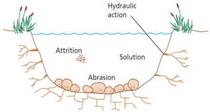
There are four main types of erosion on rivers:
- Hydraulic action - the force of the river against the banks can cause air to be trapped in cracks and crevices. The pressure weakens the banks and gradually wears it away.
- Abrasion - rocks carried along by the river wear down the river bed and banks.
- Attrition - rocks being carried by the river smash together and break into smaller, smoother and rounder particles.
- Solution - soluble particles are dissolved into the river.

Deposition of sediment may take place when a river enters an area of shallow water or when the volume of water decreases - for example, after a flood or during times of drought.
In the middle course, such as here in Silver Woods, the river has more energy and a high volume of water. The gradient here is gentle and lateral (sideways) erosion widens the river channel. The river channel also deepens. A larger river channel means there is less friction, so the water flows faster:
- As the river erodes it forms large bends, and then horseshoe-like loops called meanders.
- The formation of meanders is due to both deposition and erosion and meanders gradually migrate downstream.
- The force of the water erodes and undercuts the river bank on the outside of the bend where water flow has most energy due to less friction.
- On the inside of the bend, where the river flow is slower, material isdeposited, as there is more friction.
- Over time the horseshoe become tighter, until the ends become very close together. As the river breaks through, probably during a flood when the river has a higher discharge and more energy, and the ends join, the loop is cut-off from the main channel. The cut-off loop is called an oxbow lake.

**********************
PLEASE NOTE: YOU WON'T BE ABLE TO ACCESS THE EARTHCACHE AFTER PROLONGED RAINFALL AS THE WOODLAND BECOMES FLOODED.
Cache placed with the kind permission of the Woodland Trust
| I have earned GSA's highest level: |
 |