Skip to content

044 WGA Geo-Art Mystery Cache

This cache has been archived.

Wisconsin Geocaching Association: On 11/30/2016, the WGA GeoArt was published. The 2022 Board of Directors along with BigJim60 who is the trailboss of this awesome GeoArt have made the decision to retire the WGA GeoArt starting 09/01/2023. Thank you to all that have made the trip, or multiple trips to find these 192 caches over the years.

The cache containers will be picked up and will not qualify for the WGA Cache Rescue game.

More
Hidden : 10/15/2016
Difficulty:
1.5 out of 5
Terrain:
2 out of 5

Size: Size:   micro (micro)

Join now to view geocache location details. It's free!

Watch

How Geocaching Works

Related Web Page

Please note Use of geocaching.com services is subject to the terms and conditions in our disclaimer.

Geocache Description:

Welcome to the WGA Geo-Art Series! The cache is NOT at the posted coordinates. Please solve the puzzle below in order to find the final.

PLEASE NOTE - cache location has been moved as of 2/19/2022. If you solved this puzzle prior to this date, you will need to solve the updated puzzle to find the new coordinates. DO NOT place any throw-down caches at the original location on Klondike Dr.


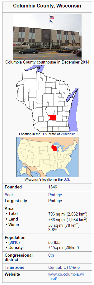
Wisconsin is made up of 72 counties, this cache is focused on Columbia County. Columbia County is a county located in the U.S. state of Wisconsin. As of the 2010 census, the population was 56,833. Its county seat and largest city is Portage. The county was created in 1846. At the time, it was in the Wisconsin Territory. Columbia County is part of the Madison, WI Metropolitan Statistical Area as well as the Madison-Janesville-Beloit, WI Combined Statistical Area. Here are a few stats about Columbia County, courtesy of Wikipedia. You can learn more about Columbia county at https://en.wikipedia.org/wiki/Columbia_County,_Wisconsin

This county's oldest geocache is GC47C6 Durward's Glen, placed by Algol.

You will find this cache at N44 36.ABC W90 04.DEF

A/F: The county was created in F84A.

B: The county has a total area of 7B6 square miles.

C: The county has a land area of C66 square miles.

D: The county's oldest cache is GC4DC6.

E: As of the 2010 census, the population was 56,E33

F/A: The county was created in F84A


SOURCE: Most of the information on this page was obtained from Wikipedia's page about this Wisconsin county.

CHECK SUM: A+B+C=22 D+E+F=16

Additional Hints (No hints available.)