Situation géographique et itinéraire :
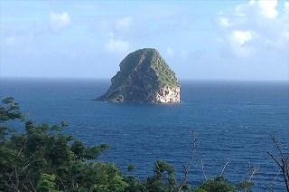
Dans l’arc des Caraïbes, l’île de la Martinique est surtout connue pour son volcan destructeur, la Montagne Pelée. Mais au sud de l’île, face au village du Diamant, en mer au sud de la presqu’île des Trois-Îlets, à 2 km au large du Morne Larcher, se dresse un autre témoin du volcanisme explosif : un volcan éteint qui a joué un rôle dans l’histoire de l’île. Un piton rocheux haut de 176 mètres et de 300 mètres de diamètre …>>>>>> le Rocher du Diamant.
Le rocher du Diamant est visible depuis tout le sud de l’île. Il se situe en face de la commune du Diamant.
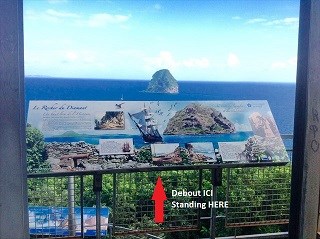
--------Il est strictement interdit de débarquer sur le Rocher du Diamant, mais vous pouvez l'admirer en allant sur la pointe du Diamant sur l'observatoire qui a été installée ---------

La pointe sud de l'île ( Morne L'archer ) et le rocher du Diamant - photo H.Salomon
Description du site / Géologie :
Le Rocher du Diamant doit son nom à sa forme en pointe biseautée et aux reflets des parois à certaines heures, évoquant ceux d'une pierre précieuse. Cet édifice correspond à la partie interne d’un dôme de lave dont la carapace a été dégagée par l’érosion ( voir schéma 2 ).
Mais comment est apparu ce joyau de la Martinique ?
Il y a 2,4 millions d'années, une longue fracture de plusieurs kilomètres de longueur se propage en surface; elle permet la remontée de magma profond entre le Diamant et le morne Champagne. À l'aplomb de la cheminée d'alimentation d'un magma stocké à plusieurs kilomètres de profondeur, se forme un dôme en surface ( voir schéma 1 ). Avec 176 m de hauteur, seule la partie interne de ce dôme est préservée par l'érosion et constitue le relief actuel de l'îlot ( voir schéma 3 ). C'est le mélange en profondeur de deux magmas chimiquement différents (l'un largement majoritaire, dacitique et clair et l'autre, basaltique et sombre) qui explique la présence des enclaves sombres et disloquées de basalte au sein de la masse dactite.
On peut observer à la base de l’édifice, une brèche grossièrement stratifiée, qui pourrait représenter les restes d’un anneau de tufs hydromagmatiques liés à sa mise en place. Une datation absolue par la méthode du Potassium-Argon a été réalisée sur un bloc de dacite du rocher du Diamant pour connaître son âge.
Quand on regarde le sommet, on comprend l'intensité de l'érosion: l'ensemble des parois présentent de vastes échancrures. Au début les parois abritaient des blocs rocheux maintenus en place par un matériau assez friable. Mais ce ciment a vraisemblablement fini par s'altérer, causant l'éboulement des rocs. Parfois on retrouve des blocs rocheux en aval amassés de façon instable et retenus par des racines de "figuiers maudits".

Au fil du temps, la couche qui entoure le culot volcanique ( schéma 2 ) finit par disparaître avec l' érosion pour arriver au stade actuel ( schéma 3 ).
Sa formation remonte à un peu près moins d'un million d'années, et c'est d'ailleurs au cours du même épisode géologique qu'est né le Morne Larcher, un petit volcan éteint de 477 m. de hauteur qui lui fait face, de l’activité volcanique qui a donné naissance à ce site.
Le Rocher du Diamant est tout aussi spectaculaire sous l’eau. Une arche de plus de 5 mètres de hauteur, souvent appelée « faille sous-marine du Diamant », traverse de part en part le rocher. Il ne s’agit en réalité pas d’une vraie faille, mais d’un méga-bloc posé par 15 m de fond contre le rocher du Diamant, donnant l’impression d’une entaille de 2 à 3 m de large sur environ 5-6 m de haut, et sur une vingtaine de mètres de long, dans laquelle les plongeurs peuvent s’engouffrer pour ressortir de l’autre côté.
===========================
Ce petit rocher, couvert de broussailles et de cactées, difficilement accessible, a pourtant joué un grand rôle stratégique durant les guerres franco-anglaises, avant de devenir un site naturel protégé et l’un des spots de plongée de La Martinique.
Son histoire militaire :
Au début du 19° siècle, la France et l’Angleterre se font la guerre pour le contrôle de l’arc Caribéen, et du canal de Sainte Lucie.
En janvier 1804, le contre-amiral Samuel Hood, s’empare par surprise du rocher. Il le fortifie aussitôt et, installe, au prix de grands efforts étant donné la topographie locale, cinq canons au sommet, avant d’y laisser une garnison d’une centaine d’hommes pour harceler la marine Française. Le rocher se voit conférer le titre honorifique de « navire de guerre » par la marine britannique, qui le nomme HMS Diamond Rock. (HMS = His Majesty’s Ship). En 1805, le gouverneur français de La Martinique, Villaret de Joyeuse, et le capitaine de vaisseau Cosmao-Kerjulien, parviennent à reprendre le Diamant aux Anglais, en privant la garnison de vivres et d’eau.
La Flore sur le Rocher
La végétation sur le Rocher est essentiellement constituée de cactus cierges, car le sol présent est pierreux et très superficiel, presqu'incapable de retenir l'eau.
Pour économiser cette ressource, de nombreuses plantes ont adopté une forme arbustive. Certaines espèces développent de véritables stratégies pour stocker l'eau, c'est le cas des cactus. Ils parviennent à gorger leurs tissus d'eau, mais en plus leur tige est spécialement conçue pour se gonfler et se rétracter selon la qualité de liquide qu'ils emmagasinent.
- 1) La végétation de paroi:
Pour la végétation de paroi, une contrainte suplémentaire se pose: pouvoir trouver un moyen de se fixer au sol. Certaines plantes ont résolu le problème en développant de petits crampons sur leurs racines. - 2) L'influence des vents marins:
La végétation a beau réussir à s'adapter à toutes sortes de facteurs cela affecte parfois sa morphologie. Les vents marins amènent souvent les plantes à pousser d'un seul côté parce que le sel des embruns freine la croissance des bourgeons situés face au vent.
Quatre espèces des milieux secs et ensoleillés en plus des cactus cierges prédominent sur l'îlet :
- Le Poirier ( Tabebula heterophylla ) avec ses fleurs rose pâle
- Une liane appelée: Bois couleuvre ( Capparis Flexuosa ) et de façon éparse, des Figuiers maudits ( ficus Citrifolia ) qui s'agrippent également aux parois grâce à leurs puissantes racines.
- Le Frangipanier blanc ( plumerie alba ) avec ses fleurs blanches parfumées.
- Les cactus ont trouvé une technique encore plus radicale pour freiner la transpiration : ils sont tout simplement dépourvus de feuilles : on observe une régression, jusqu'à devenir des épines.
La Faune :
Une multitude d'animaux peuple le Rocher. Certains sont très rares comme le crabe Gécarcinus ruricola , on le rencontre qu'en zone très sêche.
Il existe une variété de lézards : Les anolis roquet , de couleur brunâtre, ils se confondent parfaitement avec les pierres et les branches, ce qui permet d'échapper à leur prédateur protégé sur le Rocher : les oiseaux. Autrefois on trouvait des couleuvres inoffensives appelées couresses .
Les grottes du Rocher, abritent une chauve-souris appelée Brachyphylle des cavernes, existant qu'aux petites Antilles, elle a un museau en forme de groin ce qui leur vaut le surnom de chauve souris à têtes de cochon . Elles se nourissent de nectar et de fruits et jouent un rôle très important de pollinisation des arbres des forêts sèches ( notamment: le fromager et le courbaril ) dans les disséminations des graines.
La Faune aviaire du Rocher du Diamant:
Par son inaccessibilité, le Rocher du Diamant est un site particulièrement propice à la reproduction des oiseaux marins ( noddi brun, sterne bridée, phaéton à bec rouge ).
En tout, on estime qu'un millier d'oiseaux marins fréquente le Rocher, dont plus de 300 couples nicheurs ! Le Rocher du Diamant accueille 1% de la population antillaise de noddis bruns.
Les oiseaux: patrimoine menacé :
Depuis 1994, le site est géré par le Conservatoire du Littoral par un " Arrêté de Protection Biotope " régule les activités humaines sur l'îlet et les interdit notamment entre le 1er Janvier et le 31 Août ( sauf à des fins spécifiques ), de façon à ne pas perturber les oiseaux durant la nidification, et est devenu un site protégé où seuls des scientifiques sont autorisés à accoster.
Ces mesures ont permis de restreindre les menaces qui pèsent sur les oiseaux, mais une interdiction totale de débarquer serait peut être à envisager pour l'avenir.
Aujourd'hui:
L'exposition muséographique du musée Bernard David permanente et gratuite, permet de mieux connaître l'histoire du Diamant et du Rocher.
Le musée Bernard David retrace l'histoire du Diamant, des premiers habitants, les Amérindiens «Peuple de la civilisation du manioc amer», l'habitation sucrière et le rocher du Diamant : Faune et flore, enrichie de la vidéotransmission de la faune aviaire. Présentation du curé historien, Bernard DAVID, ancien prête (1927-1998) avec ses collections inédites de minéraux, livres, pièces et objets du patrimoine, collection d’objets archéologiques précolombiens qu’il a d’ailleurs légués à la commune du Diamant.
Quatre caméras HD sur les faces du rocher et une caméra sous-marine ont été installées : il suffira désormais de se rendre au musée Bernard David ou de se connecter à Internet pour observer, en direct, ce qui se passe au rocher du Diamant!
=====================================
POUR VALIDER VOTRE VISITE :
La visite du site est obligatoire pour répondre à quelques questions.
Après avoir visité le site :" Loguez cette cache "Found it" et envoyez-moi vos propositions de réponses soit via mon profil, soit via la messagerie geocaching.com (Message Center) en précisant bien le nom de l’earthcache, et je vous contacterai en cas de problème." ( pas de réponses dans les logs SVP) :
1 - a) Comment a été formé le Rocher du Diamant ?( Expliquez : Comment et quand cette roche a été formée. )
b) Donnez sa hauteur et son diamètre ?
2 - a)- Pourquoi ce nom " Rocher du Diamant "?
b)- Et comment est son relief actuel ?
3 - Qu'est ce qu'on peut observer à la base de l’édifice ?
4 - Qu'est ce qu'on trouve verticalement sous l'eau du Rocher du Diamant ?
5 - Rendez vous sur l'observatoire du Rocher du Diamant ( l'accès sur le Rocher est interdit ). Placez vous devant le panneau de la photo ci-dessous, face au rocher; relevez les coordonnées GPS du point et me les communiquer.
- Pour immortaliser votre visite , une photo du site, de vous ou votre GPS sera la bienvenue, bien que facultative.
Note :
Rappel concernant les « Earthcaches »: Il n'y a pas de conteneur à chercher ni de logbook à renseigner. Il suffit de se rendre sur les lieux, de répondre aux questions ci-dessus et de nous renvoyer les réponses.
================ENGLISH VERSION===========================
Geographical situation and route:
In the bow of the Caribbean, the island of Martinique is especially known for its destructive volcano, Montagne Pelée. But in the South of the island, in front of village of the Diamant, at sea in the South of the peninsula of Trois-Îlets, in 2 km off Morne Larcher, draws up itself another witness of the explosive volcanism: an extinct volcano
which played a role in the history of the island. A rock peak 176 meters high and 300 meters in diameter > > > > > > the Rocher du Diamant.
The Rocher du Diamant is visible since all the South of the island. It is situated in front of the municipality of the Diamant.
-----It is strictly forbidden to land on the Rock of the Diamond, but you can admire it by going on the point of the Diamond on the monitoring observatory which was installed..-----
The south point of the island ( Morne L'archer ) and the rock of the Diamond - photo H.Salomon
Description of the site / Geology:
The Rocher du Diamant owes its name to its beveled sharp shape and to the reflections of walls at certain hours, evoking those of a precious stone. This building corresponds to the internal part of a dome of lava of which the shell was cleared by the erosion (see plan 2).
But how appeared this jewel of Martinique?
There are 2,4 million years, a long fracture of several kilometers in length propagates on surface; it allows the ascent of deep magma between the Diamant and Morne champagne. Directly above the fireplace of food of a magma stored several kilometers away from depth, forms an on-surface dome (see plan 1). With 176 m of height, only the internal part of this dome is protected by the erosion and establishes the current relief of the island (see plan 3). It is the in-depth mixture of two chemically different magmas (the one widely majority, dacitique and the light and the other, basaltic and dark) which explains the presence of the enclaves dark and disrupted of basalt within the mass dactite. We can observe on the base of the building, a breach boorishly laminated, which could represent the rests of a ring of hydromagmatic tuffs bound to its implementation. A dating absolved by the method of the Potassium-argon was realized on a block of dacite of the rock of the Diamant to know its age. When we look at the summit, we understand the intensity of the erosion: all the walls presents vast bights. At the beginning walls sheltered rocky blocks maintained ready in position by a rather crisp material. But this cement most probably eventually altered, causing the collapse of rocks. Sometimes we find rocky blocks downstream amassed in a unstable way and retained by roots of " cursed fig trees ".
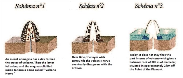
Over time, the layer which surrounds the volcanic cap (see plan 2) eventually disappears with the erosion to arrive at the current stage (see plan 3).
Its formation goes back to little near less than a million years, and it is moreover during the same geologic episode as was born Morne Larcher, a small extinct volcano of 477 m. of height which faces him, of the volcanic activity which gave birth to this site.
The Rocher du Diamant is also spectacular under the water. An arc of more than 5 meters in height, often called " submarine weakness of the Diamond ", crosses throughout the rock. It is not in reality about the real weakness, but about the mega-block put by 15 m of bottom against the rock of the Diamond, giving the impression of a notch from 2 to 3 m of wide on approximately 5-6 m of top, and on about twenty meters long, in which the divers can rush to to go out again on the other side.
==================
This small rock, covered with bushes and with cacti, with difficulty accessible, nevertheless played a large part strategic during the French-English wars, before becoming a natural protected site and one of the diving spots of Martinique.
Its military history :
At the beginning of 19 ° century, France and England wage war for the control of the Caribbean arc, and the Saint Lucia Channel.
In January, 1804, commodore Samuel Hood, seizes by surprise the rock. He strengthens It immediately and, settles, at the price of big efforts given the local topography, five artillery in the summit, before leaving it a garrison of hundred men to harass the French navy. The rock sees conferring the honorary title of "warship" by the British navy, which names him HMS Diamond Rock. (HMS = Majesty's His Ship). In 1805, the French governor of Martinique, Villaret de Joyeuse, and captain Cosmao-Kerjulien, succeed in taking back the Diamond to the English people, by depriving the garrison of foods and water.
The Flora on the Rock
The vegetation on the Rock is essentially constituted by cactus wax candles, because the present ground is rocky, very superficial and almost incapable to retain the water.
To save this resource, numerous plants adopted a shrubby shape. Certain sorts develop real strategies to store the water, it is the case of the cactus. They succeed in filling their fabrics of water, but in more their stalk is specially designed to swell and retract according to the quality of liquid which they store.
- 1) The vegetation of wall:
For the vegetation of wall, a suplémentaire constraint settles: be able to find a way to settle in the ground. Certain plants solved the problem by developing small studs on their roots.
- 2) The influence of the marine winds:
The vegetation may manage to adapt itself to any sorts of factors, it sometimes affects its morphology. The marine winds often bring plants to be pushed of a single side because the salt of sea sprays slows down the growth of buds situated in front of wind.
Four species of the circles dry and brightened up besides cactus wax candles prevail on the îlet: - the Pear tree (Tabebula heterophylla) with his flowers pale pink - A called liana: drink grass-snake (Capparis Flexuosa) and in a scattered way, cursed Fig trees (ficus Citrifolia) which also catch walls thanks to their powerful roots :
- The white Frangipani tree (plumerie alba) with its perfumed white flowers.
- Cactus found an even more radical technic to slow down the perspiration: they simply lack sheets: we observe a regression, until become thorns.
The Fauna:
A multitude of animals populates the Rock. Some are very rare as the crab Gécarcinus ruricola, we meet him that in zone very dry.
There is a variety of lizards: anolis pug, of brownish color, they become confused perfectly with stones and branches, which allows to escape their predator protected on the Rock: birds. Formerly we found harmless grass-snakes called couresses.
The caves of the Rock, shelter a bat called Brachyphylle caves, existing that in the Lesser Antilles, it has a snout in the shape of snout what is worth them the nickname of bat with pig's heads. They feeding of nectar and fruits and play a very important role of pollination of the trees of the dry forests (In particular: the cheese maker and the courbaril) in the scatterings of seeds.
The avian Fauna of the Rock of the Diamond: by its inaccessibility, the Rock of the Diamond is a site particularly convenient to the reproduction of the sea birds (brown noddy, restrained tern, red-billed phaeton).
In all, we consider that one thousand sea birds frequents the Rock, among which more than 300 couples nicheurs! The Rock of the Diamond welcomes 1 % of the West Indian population of brown noddies.
Birds: threatened heritage: since 1994, the site is managed by the Conservatoire du Littoral by an "Order of Protection Biotope" regulate the human activities on the îlet and them forbidden in particular between January 1st and August 31st (except for specific purposes), not so as to disrupt birds during the nesting, and is bécame a protected site where only scientists are authorized to tie up.
These measures allowed to restrict the threats which weigh on birds, but a total ban to land would be can be to envisage for the future.
Today:
The museographic exposure of the museum Bernard David permanent and free, allows to know better the history of the Diamond and the Rock.
The Bernard David museum redraws the story of the Diamond, the first inhabitants, the Amerindians " Populate with the civilization of the bitter manioc ", the sugar house and the rock of the Diamond: flora and fauna, enriched by the video transmission of the avian fauna. Presentation of the priest historian, Bernard David, former lends (1927-1998) with his new collections of minerals, books, rooms and objects of the heritage,, the collection of pre-Colombian archaeological objects which he moreover bequeathed to the municipality of the Diamond. Four camera HD on the faces of the rock and a submarine camera were installed: it will be enough from now on to go to the museum Bernard David or to connect in Internet to observe, directly, what takes place in the Rocher du Diamant !
================================
TO VALID YOUR VISIT:
The visit of the site is compulsory to answer some questions.
Having visited the site: "Log this hiding place" Found it "and send me your proposals of answers either via my profile, or via the messaging geocaching.com (Center message) by specifying well the name of the earthcache, and I will contact you in case of problem." (No answers in logs PLEASE):
1- a) How was formed the Rock of the Diamond?(Explain : How and when this rock was formed .)
b) Give its height and its diameter?
2 -a)- Why this name " Rock of the Diamond "?
b)- And how is its current relief?
3 - What do we can observe at the base of the building?
4 - What we find vertically under the water of the Rock of the Diamond?
5 - Go to the monitoring observatory of the Diamond Rock (the acces of the Rock is forbidden). Place you in front of the panel of the photo below, in front of the rock; raise Coordinates of the GPS of the point and communicate them to me.
- To immortalize your visit, a photo of the site, you or your GPS........ will be welcome, although optional.
Nota :
Reminder on "Earthcaches" There is no container or logbook to find information. Simply visit the site, to answer questions above and send us the answers.
=======================================================================================
Sources / Sources :
Wilkipedia, BRGM- FR, Conservatoire du littoral Martinique, UNRP 24//09/2014.
=======================================================================================
Since December 18.2016
