

Este Earthcache muestra uno de los espectáculos naturales más impresionantes de Gran Canaria. Te lleva a Punta del Corral de la Yegua, una lengua de tierra de roca volcánica cerca de Hoya del Pozo, al norte del Aeropuerto de Gran Canaria.
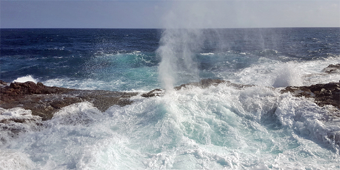
A lo largo de la costa, la roca volcánica se ahueca. Hay dos cuencas naturales de agua de mar, una más grande y otra más pequeña, que están conectadas con el Océano Atlántico a través de cuevas subterráneas, con el resultado de que las olas y las mareas impactan a nivel del mar en estas cuencas. Durante la marea alta el agua puede inundar las rocas en saltos de agua, recordándonos cascadas, y vertiendo en las cuencas.
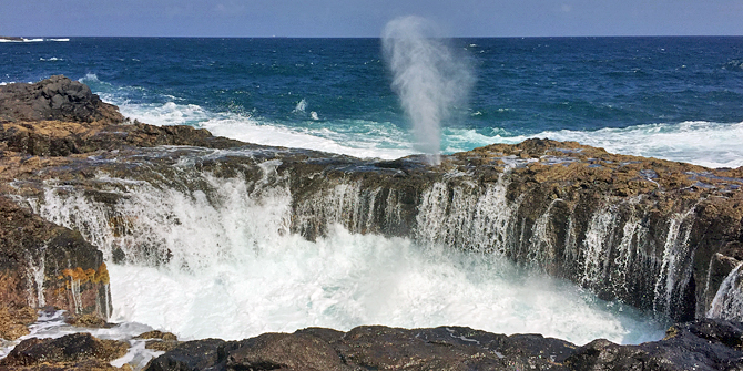
Entre la cuenca más grande y el Océano Atlántico hay un pequeño agujero en el suelo rocoso, a través del cual durante la marea alta la espuma salta por el aire varios metros, como una máquina de vapor, con sonidos que resuenan como una fuente de agua. Este espectáculo recuerda a un geiser, pero las apariencias engañan. Mientras que un geiser tiene orígenes volcánicos, el origen del Bufadero de la Garita es marítimo.
¿Qué es un respiradero?
Un respiradero es una formación geológica que se puede encontrar a menudo a lo largo de líneas de falla en las accidentadas costas de las islas volcánicas con lava o cuevas erosionadas en las rocas. En el techo de estas cuevas marinas tiene que haber una cavidad estrecha, similar a una chimenea, que, como una claraboya, llegue al exterior. Cuando las olas se introducen en esta cueva durante la marea alta, pueden producirse fuentes de agua espectaculares, dependiendo de la geometría de la cueva incluyendo la posición de la chimenea en ella y las condiciones meteorológicas adecuadas. Cuando el aire comprimido junto con la espuma o el agua del mar se escapan a través del agujero en el techo entonces se puede escuchar el característico ronquido o bufido, lo que da nombre a este espectáculo de la naturaleza, Bufadero.
Ejemplos interesantes de los Bufaderos son los que emergieron en la costa por medio de erupciones volcánicas, cuando durante el estallido la lava fluyó hacia el mar. Si durante este proceso la lava superior se enfriaba más rápido que la inferior, se creaba un túnel, donde la lava caliente podía fluir hasta que la erupción terminaba. Al final hay un canal en forma de tubo que, dependiendo de su posición, se llena con aire o agua de mar. Estos tubos pueden tener una entrada en la orilla de lcosta y también en el mar. Así surgen túneles volcánicos, en los que entra el agua de las olas y algunas veces se crean Bufaderos debido a la erosión costera sobre las rocas de origen volcánico. En algunos casos estas cuevas pueden colapsar, formandose así cuencas de agua.
(Fuentes: Diccionario básico de canarismos, Wikipedia)
El Bufadero de la Garita es el único respiradero en Gran Canaria. Básicamente funciona como un respiradero normal. Pero su peculiaridad es que este respiradero no es el final de una cueva, sino que se encuentra dentro de un puente natural, que separa una cuenca del mar. No sería improbable que la cuenca sea una cueva derrumbada. El agua llega a la cuenca a través de un acceso submarino y en la marea alta la superficie del puente también se inunda, cayendo el agua en la cuenca formando una cascada.
Los niveles de agua del mar y de las cuencas no son síncronos, variando en función de la corriente. Esto también tiene efectos en el Bufadero. Si durante esta interacción la presión bajo el puente es muy grande, el agua se eleva a través del orificio y se forma una fuente de agua - ¡el Bufadero ronca!
Para registrar este Earthcache por favor responde las siguientes preguntas y envía las respuestas correctas de la sección 1 al perfil de sandra+thorsten. Pero no publiques esas respuestas en tu registro en geocaching.com. Una vez enviadas las respuestas de la sección 1, agrega las respuestas de la sección 2 y la foto opcional al registro en geocaching.com. Una vez hecho, puedes registrar el Earthcache como encontrado sin esperar a nuestro visto bueno:
1. Describe la geología próxima al Bufadero.
a) ¿Qué color predomina en las rocas?
b) Examina el borde de la cuenca de agua más pequeña. ¿Qué forma tienen las rocas?
c) ¿Tienes idea de qué tipo de roca puede ser, teniendo en cuenta el origen volcánico de Gran Canaria?
2. Observa el Bufadero y agrega lo siguiente a tu registro:
a) Estima la altura de la fuente de agua.
b) Anota la fecha y hora de tus observaciones.
c) Averigua si estuviste allí durante el ebb (bajada, salida de agua) o durante la inundación (subida, aumento de agua) y averigua los momentos de la marea alta (nivel de agua más alto) y la marea baja (nivel de agua más bajo) junto con la altura de la marea alta, la altura de la marea baja y el coeficiente de marea. (Esta información se puede encontrar en Tabla de mareas.)
3. Nos encantaría que aportaras una foto del Bufadero (sobre todo si está activo).
Y allá va otro consejo: para ver el momento más espectacular del Bufadero se debe esperar a medias de la inundación creciente y la mayor amplitud de marea. Además los picos más altos suelen ser justo después de la luna llena y la luna nueva. También el enlace anterior al calendario de mareas puede ser útil para encontrar una fecha adecuada y momento para visitar el Bufadero.
Y por último, pero no menos importante, una advertencia: ¡la natación en el Bufadero de la Garita está estrictamente prohibida! Es muy peligroso y ya ha habido varios accidentes. El mar inunda las rocas, la resaca a través de la cueva submarina es insidiosa y el viento puede ser muy fuerte. Mejor disfrutar del espectáculo a una distancia adecuada y no caminar directamente al respiradero. ¡La natación es mucho mejor en una de las hermosas playas de Gran Canaria!
This Earthcache demonstrates one of the most impressing natural spectacles at Gran Canaria. It leads you to Punta del Corral de la Yegua, a tongue of land out of volcanic rock near Hoya del Pozo, north of the Aeropuerto de Gran Canaria.
At this coast the offshore volcanic rock is hollowed out. There are two natural seawater basins, a bigger and a smaller one, which are connected with the Atlantic Ocean through subterranean caves, with the result that waves and tides make an impact on the water level in these basins. At high tide the water might flood the rocks in cascades, reminding of waterfalls, and pour into the basins.
Between the bigger basin and the Atlantic Ocean there is a small hole in the rocky ground, through which at high tide the foam shoots up into the air for several metres, like a steam engine, with snorting sounds like a waterspout fountain. This spectacle reminds of a geysir, but appearances are deceitful. While a geysir has volcanic causes, the origin of the Bufadero del la Garita is maritime.
What is a blowhole?
A blowhole is a geological formation which can often be found along fault lines at rugged coasts on volcanic islands with lava or eroded caves in the rocks. In the ceiling of these sea caves there has to be a narrow, chimney-like, natural cavity, that, like a skylight, reaches outside. When the waves surge into this cave at high tide, it can lead to spectacular water fountains, depending on the geometry of the cave including the chimney’s position in it and the right weather conditions. When the compressed air together with foam or the seawater itself escapes through the hole in the ceiling you might hear the characteristic snorting, that in Spanish is called bufar, what led to the name of this spectacle of nature, Bufadero.
Interesting examples for Bufaderos are those that emerged at the coast through volcanic eruptions, when during the outburst lava flowed into the sea. If during this process the upper lava cools down faster than the lower, a tunnel is built, where the hot lava can flow on until the eruption ends. In the end there is a pipe-like channel which, depending on its position, fills with either air or seawater. These tubes might have an entrance on shore as well as to the sea. So volcanic tunnels emerge, into which the water of the waves enters and sometimes builds Bufaderos due to the coastal erosion on rocks with volcanic origin. In some cases these caves can collapse and so water basins are formed.
(Sources: Diccionario básico de canarismos, Wikipedia)
The Bufadero de la Garita is the only blowhole on Gran Canaria. It basically works like a normal blowhole. But its peculiarity is that this blowhole is not a the end of a cave, but within a natural bridge, that separates a basin from the sea. It is not unlikely that the basin is a collapsed sea cave. The water reaches the basin through a submarine access and at high tide also the bridge’s surface is flooded, the water pouring cascade-like into the basin.
The water levels of the sea and the basins are not synchronous, but vary depending on the current. This has also effects on the Bufadero. If during this interaction the pressure under the bridge is the greatest, the water rises through the blowhole and a water fountain squirts -- the Bufadero snorts!
To log this Earthcache please solve the following tasks and send the answers concerning number 1 via sandra+thorsten’s profile. Together with the answers for number 2 and the optional photo with task 3 you may log the cache without waiting for our okay:
1. Describe the surrounding geology of the Bufadero.
a) Which colour dominates when looking at the rocks?
b) Examining the rim of the smaller water basin, which shape do the rocks have?
c) Do you have any idea, which kind of rock this might be, considering the volcanic origin of Gran Canaria?
2. Observe the Bufadero and add the following specifications to your log:
a) Estimate the height of the water fountain.
b) Note the date and time of your observations.
c) Find out if you were there during ebb (sinking, outgoing water) or flood (increasing, rising water) and find out the point of time of high tide (highest water level) and low tide (lowest water level) before respectively after your observations together with the high tide height, the low tide height and the tidal coefficient. (This information can be found under Tides4fishing.)
3. We would be pleased about a photo of the (preferably active) Bufadero.
And here another tip: The most spectacular activity of the Bufadero is to expect in the middle of the rising flood and the highest tidal amplitude together with the highest spouts are usually right after full moon and new moon. As well the above link to the tidal calendar can be helpful to find an appropriate date and point of time to visit the Bufadero.
And last but not least a warning: Swimming at the Bufadero de la Garita is strictly forbidden! It is very dangerous and there already have been several accidents. The sea floods the rocks, the undertow through the submarine cave is insidious and the wind can be very strong. Better enjoy the spectacle within adequate distance and don’t walk directly to the blowhole. Swimming is much better at one of the beautiful beaches of Gran Canaria!

Dieser Earthcache zeigt dir eines der spektakulärsten Naturschauspiele auf Gran Canaria. Er führt dich an die Punta del Corral de la Yegua, eine felsige Landzunge aus Vulkangestein bei Hoya del Pozo nördlich des Aeropuerto de Gran Canaria.
An dieser Küste ist der vorgelagerte vulkanische Fels ausgehöhlt. Es gibt zwei natürliche Meerwasserbecken, ein größeres und ein kleineres, welche durch unterirdische Höhlen mit dem Atlantik verbunden sind, so dass Wellen und Gezeiten sich auch auf den Wasserstand in diesen Becken auswirken. Bei Hochwasser kann das Wasser auch die Felsen überspülen und sich kaskadenartig, an Wasserfälle erinnernd, in die Becken ergießen.
Zwischen dem größeren Becken und dem Atlantik befindet sich eine kleine Öffnung im Boden des Felsens, durch welche bei Flut wie bei einer Dampfmaschine die Gischt mit fauchenden Geräuschen in einer Fontäne springbrunnenartig meterhoch in die Luft schießt. Dieses Schauspiel erinnert an einen Geysir, doch der Schein trügt. Während ein Geysir vulkanische Ursachen hat, ist der Bufadero de la Garita maritimen Ursprungs.
Was ist ein Blowhole?
Ein Blowhole, im Deutschen auch Blasloch genannt, ist eine geologische Formation, welche man häufig entlang von Verwerfungslinien an schroffen Küsten von Vulkaninseln mit Lavahöhlen oder erodierten Höhlen in den Felsen findet. In der Decke dieser Meereshöhlen muss sich ein enger, kaminartiger, natürlicher Hohlraum befinden, der über die Höhlendecke ähnlich einem Oberlicht hinauf ins Freie reicht. Wenn die Wellen bei Flut in diese Höhle branden, tritt je nach Lage des Hohlraums die komprimierte Luft zusammen mit einer Gischt oder auch dem Meerwasser selbst aus dem Loch in der Decke aus, was bei geeigneter Geometrie der Höhle und den richtigen Wetterbedingungen zu spektakulären Wasserfontänen begleitet von einem lauten, charakteristischen Fauchen führen kann. Dieses Fauchen nennt sich im Spanischen bufar und gab dem Naturschauspiel seinen Namen, Bufadero.
Interessante Beispiele für Bufaderos sind diejenigen, die an der Küste durch vulkanische Eruptionen entstanden sind, bei denen die Lava während des Ausbruchs bis in das Meer geflossen ist. Kühlt sich bei diesem Vorgang die obere Lava schneller ab als die untere, bildet sich ein Tunnel, in dem die heiße Lava weiterfließen kann, bis die Eruption aufhört. Am Ende bleibt ein rohrartiger Kanal, welcher sich anschließend je nach Lage mit Luft bzw. Meerwasser füllt. Diese Röhren können auch jeweils einen Eingang an Land und im Meer haben. So entstehen vulkanische Tunnel, in die das Wasser der Wellen eintreten und aufgrund der Küstenerosion in Gesteinen vulkanischen Ursprungs Bufaderos bilden kann. In einigen Fällen können diese Höhlen auch kollabieren und so Wasserbecken bilden.
(Quellen: Diccionario básico de canarismos, Wikipedia)
Der Bufadero de la Garita ist das einzige Blowhole auf Gran Canaria. Er funktioniert prinzipiell so, wie ein übliches Blowhole. Seine Besonderheit ist jedoch, dass sich das Blasloch nicht am Ende einer Höhle befindet, sondern in einer natürlichen Brücke, die ein Becken vom Meer trennt. Es ist nicht unwahrscheinlich, dass es sich bei diesen Becken um eingestürzte Meereshöhlen handelt. Das Wasser gelangt durch einen unterseeischen Zugang in dieses Becken, bei Hochwasser wird auch die Oberfläche der Brücke überspült und das Wasser fließt kaskadenartig in das Becken.
Die Wasserstände des Meeres und der Beckens sind dabei nicht synchron, sondern variieren je nach Strömung. Dies hat auch Auswirkungen auf den Bufadero. Ist bei diesem Wechselspiel der Druck unter der Brücke am größten, steigt das Wasser durch das Blowhole und eine Wasserfontäne spritzt aus dem Blasloch -- der Bufadero faucht!
Um diesen Earthcache loggen zu können, löse bitte folgende Aufgaben und schicke uns die Antworten zu Punkt 1 über das Profil von sandra+thorsten zu. Mit den Antworten zu Punkt 2 und dem optionalen Foto bei Punkt 3 kannst du dann anschließend loggen, ohne auf eine weitere Freigabe von uns zu warten:
1. Beschreibe die Geologie um den Bufadero herum.
a) Welche Farbe herrscht hauptsächlich bei dem Gestein vor?
b) Welche Form haben die Felsen am Rand des kleineren der beiden Wasserlöcher?
c) Hast du eine Idee, um welche Gesteinsart es sich handeln könnte, wenn du berücksichtigst, dass es sich bei Gran Canaria um eine Vulkaninsel handelt?
2. Beobachte den Bufadero und mache folgende Angaben in deinem Log.
a) Schätze die Höhe der Wasserfontäne.
b) Gib das Datum und die Uhrzeit deiner Beobachtung an.
c) Finde heraus, ob du bei Ebbe (sinkendes, ablaufendes Wasser) oder Flut (ansteigendes, auflaufendes Wasser) vor Ort warst und ermittle den Zeitpunkt des Hochwassers (höchster Wasserstand) und Niedrigwassers (tiefster Wasserstand) vor bzw. nach deiner Beobachtung samt der Hochwasserhöhe, der Niedrigwasserhöhe und des Gezeitenkoeffizients. (Diese Informationen kannst du unter Gezeiten Fisch finden.)
3. Über ein Foto des (möglichst aktiven) Bufaderos würden wir uns in deinem Log sehr freuen.
Hier noch ein kleiner Tipp: Am spektakulärsten ist der Bufadero zur Mitte der einlaufenden Flut und der höchste Tidenhub und somit auch die höchsten Fontänen sind in der Regel kurz nach Vollmond und Neumond zu erwarten. Auch hier kann der obige Link zum Gezeitenkalender hilfreich sein, ein geeignetes Datum und einen geeigneten Zeitpunkt für den Besuch beim Bufadero zu finden.
Und zu guter Letzt noch eine Warnung: Das Baden am Bufadero de la Garita ist verboten! Es ist sehr gefährlich und es gab bereits mehrere Unfälle. Das Meer überspült die Felsen, der Sog durch die unterirdische Höhle ist tückisch und der Wind kann sehr stürmisch sein. Genießt das Schauspiel am besten mit ausreichendem Abstand und geht möglichst nicht direkt bis an das Blasloch. Baden könnt ihr viel besser an einem der wunderschönen Strände Gran Canarias!