The Cordilleran ice sheet was a major ice sheet that periodically covered large parts of North America during glacial periods over the last approximately 2.6 million years. Over the past 250,000 years, Western Washington felt the effects of the Cordilleran ice sheet in four cycles of glacial advances and retreats during alternating climate cooling and warming. These were the cycles that have left the most evidence in our current geology and topography much of which we drive by or photograph with little or no appreciation of the forces that shaped them or the massiveness of the glaciers.
As glaciers retreated in these cycles, large portions broke off the main lobes or were covered in glacial till (sand, boulders and other material riding within the glacier or carved from the bedrock and sedimentary rock and carried by the glacier). The till protected the ice chunks from melting for long periods of time allowing them to settle and for further sediment to build around them. As these massive landlocked icebergs eventually melted, depressions in the landscape were left that are described as "kettles". Literally these kettles are generally round or oblong with a bowl-like bottom and lined with the glacial till and subsequent sedimentation that was deposited in them.
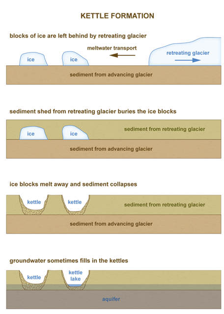
When kettles form deep enough such that the aquifer (the underground layer of rock, sand, gravel and silt that holds groundwater) is exposed, a kettle pond or lake is formed. Although not immediately adjacent to Kettle View Park, there are ample numbers of such ponds and lakes in the Olympia area. Shallower kettles that do not reach the aquifer can be relatively dry and over long periods of time have become overgrown by vegetation and become part of the background landscape of even our most urban of areas. Such are the kettles that can be viewed from this park.
The posted coordinates will bring you to the center of the park in the vicinity of the covered picnic tables.
New Waypoints added on July 8, 2026:
Viewpoint 1 can be reached from the Trailhead Waypoint which is a social trail near the western park boundary.
Viewpoint 2 can be reached by a short walk on the established park trail system.
To log a find for this cache, please message the CO your answers to the following questions that can be gleaned from the above discussion and observations made from the Viewpoints. Please do not insert any of your answers into your log. You may log the find before receiving an OK from the CO. Also pictures are encouraged.
1. What are two of the named nearby all-season bodies of water that are deep kettles?
2. At the northeast corner of the park is a point at which a seaonally wet/dry depression can be directly observed. (Note, this is not one of the all-season bodies of water mentioned in Question 1 above.). Name two features of this depression relative to the surrounding general area that confirm to you that it is indeed a glacially formed kettle.
3. Estimate how deep this kettle is relative to the surrounding features.
4. As you walk the trails around the park, approximately how many kettles do you count within and immediately adjacent to the park?