STOP! Read this first.
There is no container to find at ground zero. You must read this earth science lesson and send me your answers to the questions at the bottom; then you may log it as found. This earthcache is located in Elk Island National Park and has been placed with the permission and assistance of Parks Canada. If you do not have a national park pass, you must pay daily admission. Parking is available at the Astotin Lake Recreation Area.
With gratitude to Cameron Johnson, Tristan Drozdiak, Rachel Dennis, and the team at Elk Island National Park.
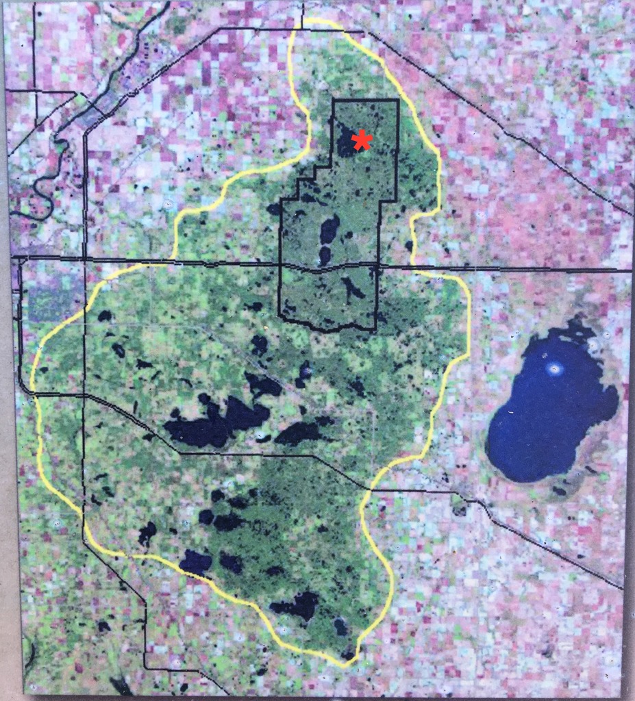
The Cooking Lake Moraine, known popularly as the Beaver Hills (or Amiskwaciy, in Cree), is actually a series of glacial moraines covering 1,572 km2 across five counties (Strathcona, Leduc, Beaver, Lamont, and Camrose) in Central Alberta. Though not very prominent relative to the surrounding countryside, it can be thought of as an upland “island” of boreal forest in a sea of prairie and aspen parkland.
Moraines form where soil, gravel, boulders, and other debris carried by glaciers (collectively, “till”) is deposited, having been scooped up by the ice and carried away from its original location(s). There are several types of moraines, which are classified according to origin, glacial position, or shape. Below are some of the more common types of moraines.
- Lateral moraines are parallel ridges of debris deposited along the sides of a glacier. They form in valleys as debris falls down onto the glacier from above. Lateral moraines usually persist as high ridges after the glacier melts, as their formation atop the ice prevents them from being worn down as it moves.
- Ground moraines are till-covered areas with irregular terrain that lack ridges. They accumulate at the base of ice and may be reshaped into drumlins as the ice and meltwater move overtop.
- End/terminal moraines form at the frontal edge of the glacier (the “toe”) where the glacier stops moving forward. When the rate of melting reaches equilibrium with the glacier’s forward progress, the movement of ice continues to bring till forward and deposits it in the same location, building a larger moraine over time, until the glacier melts faster than it can advance and it “retreats”.
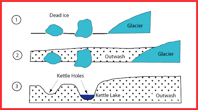
The terrain of the Beaver Hills is characterized by small hills (known as hummocks or “knobs”) and frequent depressions, many of which support small lakes and other wetlands. These depressions are known as kettles, and when filled with water, are known as kettle lakes. Kettles form when large chunks of ice fall off a glacier and are buried by till. As the till settles, the buried ice slowly melts, causing the new ground above it to shift and sink or collapse, forming the kettles. Kettle lakes tend to be shallow and roughly circular in shape. The graphic below demonstrates this process. Together, the terrain of the Beaver Hills has come to be described as “knob and kettle”.
The surrounding fertile prairie is the result of the vast Laurentide Ice Sheet melting to create glacial Lake Edmonton. For thousands of years, sediments in the lake settled as lacustrine deposits on the lake bottom. When the lake eventually drained, it left behind an abundance of rich soil and flat land ideal for agriculture. In contrast, the higher elevation of the Beaver Hills moraines remained above the lake, so the tilly soil and hummocky terrain deterred potential agriculture.
With poor soil quality and little economic potential, coupled with rich biodiversity, it is perhaps unsurprising that so much of the Beaver Hills remained largely undeveloped and was later set aside for conservation and recreation. Elk Island National Park, the Ministik Bird Sanctuary, the Cooking Lake-Blackfoot Provincial Recreation Area, Miquelon Lake Provincial Park, and the Strathcona Wilderness Centre have all been established to preserve and enjoy the natural environment, collectively covering about one third of the moraines’ total area.
Sources
- Beaver Hills Initiative. Ecological primer – what makes the Beaver Hills so special? http://www.beaverhills.ca/media/resources/ecoprimer.pdf (link broken - uploaded here)
- Swinnerton, Guy. The Beaver Hills moraine: a distinctive Alberta landscape. 2015 October 06. http://www.natureconservancy.ca/en/blog/archive/beaver-hills-moraine.html#.XhqTyut7lN0
- Author Unknown. 2011. Kettle Hole. (17 May 2011). Accessed November 13, 2013.
- https://en.wikipedia.org/wiki/Beaver_Hills_%28Alberta%29
- https://en.wikipedia.org/wiki/Moraine
-------------------------------------------------
To log this earthcache as found, first e-mail/message me the answers to the following questions (don’t post them in your log!). You may log it as found without hearing a response from me, but e-mails/messages with missing or poor answers to the first three questions may be deleted, and the cacher notified as to the reason(s) why.
1. Which of the listed types of moraines do you think the Beaver Hills are characteristic of? (not on the sign)
2. Knowing how kettle lakes form, do you think Astotin Lake is an example of a kettle lake? (not on the sign)
3. What does the sign at waypoint #2 (“Where Glaciers Met”) call the bluff you’re standing on? How is it described?
4. (Optional) Post a photo of yourself and your GPSr with Astotin Lake in the background.
| I have earned GSA's highest level: |
 |
FTF: Ninja Fairies and cailloupot
Congratulations to becauseadventure, charlotte_reimer, and TheKlassyOnes for finding your first earthcache!